TopoQuest Logo
Do you find TopoQuest useful?
Help keep TopoQuest running and adding new maps/features by donating!
Bitcoin:  19c7KJd3qBynnjoSw5npx9KScwjBe4ifkT
Litecoin:  LXs6TkuXGGXo1vDsWCkWVdjQX94eUKd6ui
Home View Maps Find Maps Find Places Resources & Links


Black Moshannon, Pennsylvania Topographic Map

USGS Map Title: Black Moshannon, PA
USGS Map MRC: 40078H1
DRG (GeoTIFF) Download: o40078h1.tif


Neighboring USGS Topographic Map Quads:


  Frenchville, PA  
41078A2
 

  Karthaus, PA  
41078A1
 

  Snow Shoe, PA  
41077A8
 

  Philipsburg, PA  
40078H2
 

  Black Moshannon, PA  
40078H1
 

  Bear Knob, PA  
40077H8
 

  Sandy Ridge, PA  
40078G2
 

  Port Matilda, PA  
40078G1
 

  Julian, PA  
40077G8


Map MRC Location:

N41°
W79°
N41°
W78°
H8 H7 H6 H5 H4 H3 H2 H1
G8 G7 G6 G5 G4 G3 G2 G1
F8 F7 F6 F5 F4 F3 F2 F1
E8 E7 E6 E5 E4 E3 E2 E1
D8 D7 D6 D5 D4 D3 D2 D1
C8 C7 C6 C5 C4 C3 C2 C1
B8 B7 B6 B5 B4 B3 B2 B1
A8 A7 A6 A5 A4 A3 A2 A1
N40°
W79°
N40°
W78°

Black Moshannon, PA USGS 1:24K Topographic Map Preview:
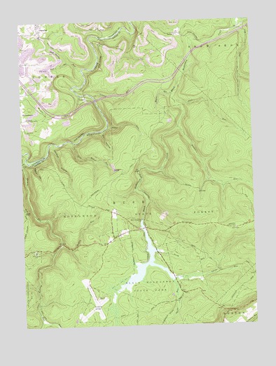
Black Moshannon, PA USGS Topographic Map
Click on map above to begin viewing in our Map Viewer.

This topographic map contains these locations and features:
Feature Name Type Latitude Longitude GNIS ID View Map
AntesLocaleN40.9156°W78.0581°1213057View Map
Arctic SpringsSpringN40.9056°W78.1181°1201881View Map
Arctic Springs ParkParkN40.9056°W78.1181°1168375View Map
Beaver MillsPopulated PlaceN40.8892°W78.0381°1202271View Map
Benner RunStreamN40.9562°W78.0395°1169247View Map
Black Moshannon DamDamN40.9184°W78.0600°1169719View Map
Black Moshannon LakeReservoirN40.9184°W78.0547°1195145View Map
Black Moshannon State ParkParkN40.8984°W78.0564°1169720View Map
Browns RunStreamN40.9695°W78.0928°1170403View Map
Dry HollowValleyN40.9546°W78.0812°1173506View Map
Dry Hollow TrailTrailN40.9206°W78.0364°1206386View Map
East Branch Rock RunStreamN40.9998°W78.0028°1173768View Map
GortonPopulated PlaceN40.9942°W78.0406°1203700View Map
Grassflat RunStreamN40.9803°W78.0914°1175986View Map
Groe RunStreamN40.9423°W78.1178°1202934View Map
Hall RunStreamN40.9562°W78.0395°1176397View Map
Hunters RocksSummitN40.9403°W78.0750°1177615View Map
Hutton RunStreamN40.9087°W78.1042°1177662View Map
Kephart DamDamN40.9184°W78.0547°1195146View Map
Knox RunStreamN40.9837°W78.0975°1178623View Map
Laurel RunStreamN40.9692°W78.0853°1178987View Map
Meyers RunStreamN40.9701°W78.0425°1180989View Map
Mid-State AirportAirportN40.8862°W78.0842°1194126View Map
Middle Branch Rock RunStreamN40.9776°W78.0056°1192924View Map
Moshannon State ForestForestN40.9209°W78.0172°1209351View Map
North RunStreamN40.9051°W78.0514°1182627View Map
North Run TrailTrailN40.9101°W78.0278°1206388View Map
Old Huckleberry TrailTrailN40.9289°W78.0786°1206384View Map
Panther HollowValleyN40.9421°W78.1179°1200105View Map
PealePopulated PlaceN40.9978°W78.0814°1204370View Map
Philipsburg Radio Range StationLocaleN40.9603°W78.1222°1183664View Map
Potter RunStreamN40.9564°W78.0778°1184338View Map
Rattlesnake Lookout TowerTowerN40.9148°W78.0097°1213336View Map
Rattlesnake TrailTrailN40.9251°W78.0167°1206387View Map
Rock RunStreamN40.9998°W78.0028°1193206View Map
Sawdust HollowValleyN40.9497°W78.1073°1187018View Map
Shirks RunStreamN40.8920°W78.0431°1193349View Map
Short TrailTrailN40.9284°W78.0486°1206385View Map
Sixmile RunStreamN40.9431°W78.1228°1193371View Map
Smays RunStreamN40.8959°W78.0264°1187844View Map
Smays TrailTrailN40.8914°W78.0264°1206389View Map
Tark Hill RunStreamN40.9503°W78.0964°1189280View Map
Turtle RocksLocaleN40.9223°W78.1239°1189975View Map
ViaductLocaleN40.9681°W78.0892°1190394View Map

Note: Coordinates in the location and feature list above are referenced to NAD83 datum.


Copyright (C) 2008-2025 Ryan Niemi / Sunset Dynamics ... All Rights Reserved