TopoQuest Logo
Do you find TopoQuest useful?
Help keep TopoQuest running and adding new maps/features by donating!
Bitcoin:  19c7KJd3qBynnjoSw5npx9KScwjBe4ifkT
Litecoin:  LXs6TkuXGGXo1vDsWCkWVdjQX94eUKd6ui
Home View Maps Find Maps Find Places Resources & Links


Bear Knob, Pennsylvania Topographic Map

USGS Map Title: Bear Knob, PA
USGS Map MRC: 40077H8
DRG (GeoTIFF) Download: o40077h8.tif


Neighboring USGS Topographic Map Quads:


  Karthaus, PA  
41078A1
 

  Snow Shoe, PA  
41077A8
 

  Snow Shoe SE, PA  
41077A7
 

  Black Moshannon, PA  
40078H1
 

  Bear Knob, PA  
40077H8
 

  Bellefonte, PA  
40077H7
 

  Port Matilda, PA  
40078G1
 

  Julian, PA  
40077G8
 

  State College, PA  
40077G7


Map MRC Location:

N41°
W78°
N41°
W77°
H8 H7 H6 H5 H4 H3 H2 H1
G8 G7 G6 G5 G4 G3 G2 G1
F8 F7 F6 F5 F4 F3 F2 F1
E8 E7 E6 E5 E4 E3 E2 E1
D8 D7 D6 D5 D4 D3 D2 D1
C8 C7 C6 C5 C4 C3 C2 C1
B8 B7 B6 B5 B4 B3 B2 B1
A8 A7 A6 A5 A4 A3 A2 A1
N40°
W78°
N40°
W77°

Bear Knob, PA USGS 1:24K Topographic Map Preview:
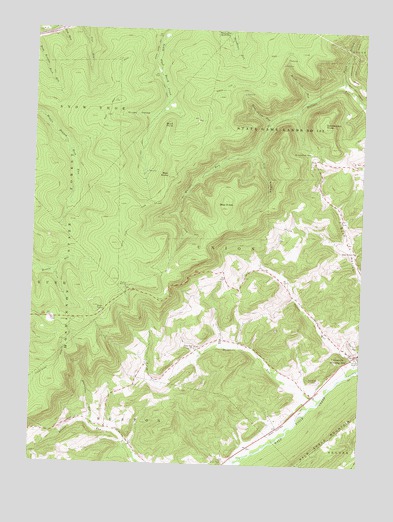
Bear Knob, PA USGS Topographic Map
Click on map above to begin viewing in our Map Viewer.

This topographic map contains these locations and features:
Feature Name Type Latitude Longitude GNIS ID View Map
Bear KnobSummitN40.9489°W77.9264°1168884View Map
Bear RocksSummitN40.9576°W77.9486°1168912View Map
Belleview SchoolSchoolN40.8812°W77.9622°1196978View Map
Birch Lick RunStreamN40.9801°W77.8964°1169639View Map
Borough of UnionvilleCivilN40.9063°W77.8767°1215064View Map
Brushy HollowValleyN40.9750°W77.9562°1170475View Map
Buck PointCliffN40.9734°W77.9489°1170527View Map
Bush Hollow ChurchChurchN40.9367°W77.8767°1170765View Map
Dicks RunStreamN40.8942°W77.8889°1173255View Map
Dicks Run ChurchChurchN40.9084°W77.9372°1173256View Map
Dry HollowValleyN40.9657°W77.9157°1173507View Map
Eagle Ridge GliderportAirportN40.8842°W77.9031°1212638View Map
Fleming Post OfficePost OfficeN40.9058°W77.8761°2773138View Map
Foxy HollowValleyN40.9474°W77.9453°1175121View Map
Ganderstep KnobSummitN40.9726°W77.8892°1175408View Map
Grindstone GapGapN40.9651°W77.8936°1176246View Map
North Branch Wallace RunStreamN40.9848°W77.8831°1193042View Map
Oak Ridge CemeteryCemeteryN40.8994°W77.8900°1182795View Map
Rattlesnake Mountain FarmLocaleN40.9264°W77.9361°2611287View Map
Ridge Soaring AirportAirportN40.8839°W77.9072°1194128View Map
Rock Cabin RunStreamN40.9739°W77.9097°1185244View Map
State Game Lands Number 103ParkN40.9712°W77.9050°1193428View Map
Township of UnionCivilN40.9403°W77.9031°1216140View Map
UnionvillePopulated PlaceN40.9073°W77.8756°1193583View Map
WGMR-FM (Tyrone)TowerN40.9195°W77.9742°1200266View Map
Whetstone RunStreamN40.8859°W77.9761°1191229View Map

Note: Coordinates in the location and feature list above are referenced to NAD83 datum.


Copyright (C) 2008-2025 Ryan Niemi / Sunset Dynamics ... All Rights Reserved