TopoQuest Logo
Do you find TopoQuest useful?
Help keep TopoQuest running and adding new maps/features by donating!
Bitcoin:  19c7KJd3qBynnjoSw5npx9KScwjBe4ifkT
Litecoin:  LXs6TkuXGGXo1vDsWCkWVdjQX94eUKd6ui
Home View Maps Find Maps Find Places Resources & Links


Keating, Oregon Topographic Map

USGS Map Title: Keating, OR
USGS Map MRC: 44117G5
DRG (GeoTIFF) Download: o44117g5.tif


Neighboring USGS Topographic Map Quads:


  Keating NW, OR  
44117H6
 

  Sawtooth Ridge, OR  
44117H5
 

  Balm Creek Reservoir, OR  
44117H4
 

  Virtue Flat, OR  
44117G6
 

  Keating, OR  
44117G5
 

  Glasgow Butte, OR  
44117G4
 

  Encina, OR  
44117F6
 

  Oxman, OR  
44117F5
 

  Lawrence Creek, OR  
44117F4


Map MRC Location:

N45°
W118°
N45°
W117°
H8 H7 H6 H5 H4 H3 H2 H1
G8 G7 G6 G5 G4 G3 G2 G1
F8 F7 F6 F5 F4 F3 F2 F1
E8 E7 E6 E5 E4 E3 E2 E1
D8 D7 D6 D5 D4 D3 D2 D1
C8 C7 C6 C5 C4 C3 C2 C1
B8 B7 B6 B5 B4 B3 B2 B1
A8 A7 A6 A5 A4 A3 A2 A1
N44°
W118°
N44°
W117°

Keating, OR USGS 1:24K Topographic Map Preview:
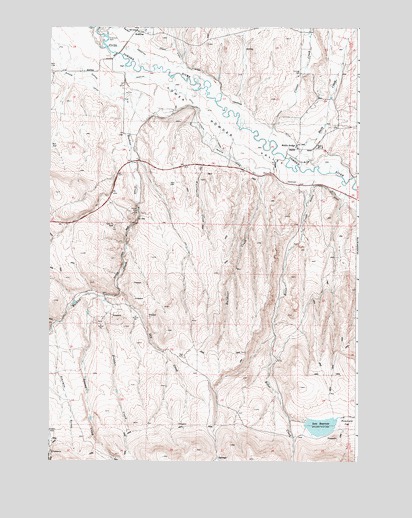
Keating, OR USGS Topographic Map
Click on map above to begin viewing in our Map Viewer.

This topographic map contains these locations and features:
Feature Name Type Latitude Longitude GNIS ID View Map
Balm CreekStreamN44.8349°W117.5172°1137486View Map
Boulder CreekStreamN44.7974°W117.6013°1117977View Map
Bulldozer CreekStreamN44.8318°W117.5388°1118297View Map
Clover CreekStreamN44.8421°W117.5366°1119029View Map
Constance ReservoirReservoirN44.7928°W117.6096°1131962View Map
Cranston DitchCanalN44.8663°W117.5833°1158185View Map
Cranston ReservoirReservoirN44.8488°W117.5338°1131960View Map
Dry CreekStreamN44.7988°W117.5969°1120120View Map
East Clover CreekStreamN44.8724°W117.5205°1141516View Map
KeatingPopulated PlaceN44.8740°W117.5905°1122641View Map
Keating Elementary SchoolSchoolN44.8746°W117.5907°2364470View Map
Keating Grange HallBuildingN44.8621°W117.5244°1639277View Map
Keating Post Office (historical)Post OfficeN44.8740°W117.5905°1165470View Map
Keating Rural Fire Protection DistrictBuildingN44.8619°W117.5243°2576686View Map
Love DamDamN44.7616°W117.5210°1131340View Map
Love DitchCanalN44.7629°W117.5046°1158335View Map
Love ReservoirReservoirN44.7603°W117.5149°1123536View Map
Lower Powder ValleyBasinN44.8429°W117.5502°1123583View Map
McCann SpringSpringN44.8638°W117.5459°1131961View Map
Middle BridgeLocaleN44.8402°W117.5252°1124085View Map
Palmer (historical)LocaleN44.7985°W117.6108°1131959View Map
Perkins DitchCanalN44.8296°W117.5166°1158416View Map
Prichard Post Office (historical)Post OfficeN44.8374°W117.5294°1164616View Map
Ritter CreekStreamN44.8338°W117.5183°1126051View Map
Ruckles CreekStreamN44.8738°W117.6083°1126353View Map
Second CreekStreamN44.7974°W117.6055°1126718View Map
Stevens GulchValleyN44.7888°W117.6233°1127595View Map
Tucker CreekStreamN44.8735°W117.6027°1128274View Map
Waterspout CreekStreamN44.8413°W117.5638°1128730View Map

Note: Coordinates in the location and feature list above are referenced to NAD83 datum.


Copyright (C) 2008-2025 Ryan Niemi / Sunset Dynamics ... All Rights Reserved