TopoQuest Logo
Do you find TopoQuest useful?
Help keep TopoQuest running and adding new maps/features by donating!
Bitcoin:  19c7KJd3qBynnjoSw5npx9KScwjBe4ifkT
Litecoin:  LXs6TkuXGGXo1vDsWCkWVdjQX94eUKd6ui
Home View Maps Find Maps Find Places Resources & Links


Sawtooth Ridge, Oregon Topographic Map

USGS Map Title: Sawtooth Ridge, OR
USGS Map MRC: 44117H5
DRG (GeoTIFF) Download: o44117h5.tif


Neighboring USGS Topographic Map Quads:


  Medical Springs, OR  
45117A6
 

  Flagstaff Butte, OR  
45117A5
 

  Bennet Peak, OR  
45117A4
 

  Keating NW, OR  
44117H6
 

  Sawtooth Ridge, OR  
44117H5
 

  Balm Creek Reservoir, OR  
44117H4
 

  Virtue Flat, OR  
44117G6
 

  Keating, OR  
44117G5
 

  Glasgow Butte, OR  
44117G4


Map MRC Location:

N45°
W118°
N45°
W117°
H8 H7 H6 H5 H4 H3 H2 H1
G8 G7 G6 G5 G4 G3 G2 G1
F8 F7 F6 F5 F4 F3 F2 F1
E8 E7 E6 E5 E4 E3 E2 E1
D8 D7 D6 D5 D4 D3 D2 D1
C8 C7 C6 C5 C4 C3 C2 C1
B8 B7 B6 B5 B4 B3 B2 B1
A8 A7 A6 A5 A4 A3 A2 A1
N44°
W118°
N44°
W117°

Sawtooth Ridge, OR USGS 1:24K Topographic Map Preview:
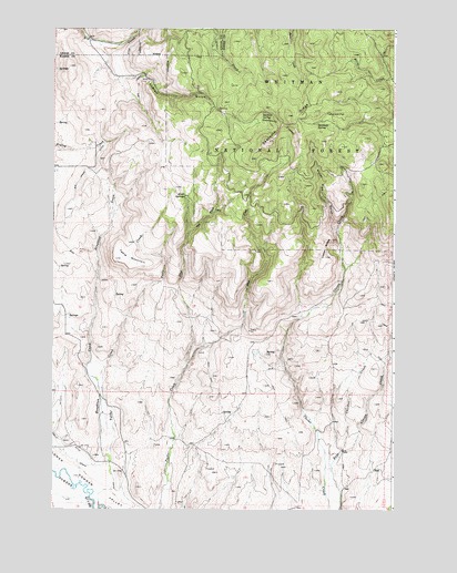
Sawtooth Ridge, OR USGS Topographic Map
Click on map above to begin viewing in our Map Viewer.

This topographic map contains these locations and features:
Feature Name Type Latitude Longitude GNIS ID View Map
Big Creek DitchCanalN44.9627°W117.6122°1117608View Map
Burkemont (historical)LocaleN44.9263°W117.5669°1131967View Map
Burkemont Post Office (historical)Post OfficeN44.9263°W117.5669°1164984View Map
Chicken CreekStreamN44.8904°W117.5191°1118880View Map
Copper ButtesSummitN44.9452°W117.5235°1119267View Map
East Fork Tucker CreekStreamN44.9124°W117.5763°1120329View Map
Erwin (historical)Populated PlaceN44.8879°W117.6058°1131966View Map
Erwin Post Office (historical)Post OfficeN44.8879°W117.6058°1165224View Map
Fruit SpringsSpringN44.9567°W117.5763°1121014View Map
Houghton CreekStreamN44.8877°W117.6041°1122070View Map
Langrell GulchValleyN44.9874°W117.5977°1122954View Map
Sardine SpringSpringN44.9783°W117.5486°1126607View Map
Sawtooth CraterGapN44.9754°W117.5422°1126622View Map
Sawtooth RidgeRidgeN44.9774°W117.5402°1126624View Map
Sawtooth SpringSpringN44.9755°W117.5286°1126625View Map
Table CreekStreamN44.8868°W117.6044°1127857View Map
Table MountainSummitN44.9402°W117.6027°1127864View Map
Tamarack FlatFlatN44.9771°W117.5230°1127878View Map
Water Pipe GulchValleyN44.9465°W117.5216°1128718View Map
West Fork Tucker CreekStreamN44.9124°W117.5760°1128872View Map

Note: Coordinates in the location and feature list above are referenced to NAD83 datum.


Copyright (C) 2008-2025 Ryan Niemi / Sunset Dynamics ... All Rights Reserved