TopoQuest Logo
Do you find TopoQuest useful?
Help keep TopoQuest running and adding new maps/features by donating!
Bitcoin:  19c7KJd3qBynnjoSw5npx9KScwjBe4ifkT
Litecoin:  LXs6TkuXGGXo1vDsWCkWVdjQX94eUKd6ui
Home View Maps Find Maps Find Places Resources & Links


Keownville, Mississippi Topographic Map

USGS Map Title: Keownville, MS
USGS Map MRC: 34088E8
DRG (GeoTIFF) Download: o34088e8.tif


Neighboring USGS Topographic Map Quads:


  Blue Mountain, MS  
34089F1
 

  Ripley, MS  
34088F8
 

  Dumas, MS  
34088F7
 

  Myrtle, MS  
34089E1
 

  Keownville, MS  
34088E8
 

  Pleasant Ridge, MS  
34088E7
 

  New Albany West, MS  
34089D1
 

  New Albany East, MS  
34088D8
 

  Ellistown, MS  
34088D7


Map MRC Location:

N35°
W89°
N35°
W88°
H8 H7 H6 H5 H4 H3 H2 H1
G8 G7 G6 G5 G4 G3 G2 G1
F8 F7 F6 F5 F4 F3 F2 F1
E8 E7 E6 E5 E4 E3 E2 E1
D8 D7 D6 D5 D4 D3 D2 D1
C8 C7 C6 C5 C4 C3 C2 C1
B8 B7 B6 B5 B4 B3 B2 B1
A8 A7 A6 A5 A4 A3 A2 A1
N34°
W89°
N34°
W88°

Keownville, MS USGS 1:24K Topographic Map Preview:
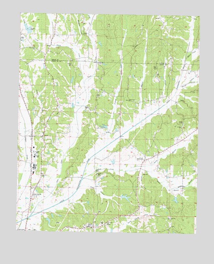
Keownville, MS USGS Topographic Map
Click on map above to begin viewing in our Map Viewer.

This topographic map contains these locations and features:
Feature Name Type Latitude Longitude GNIS ID View Map
BakerPopulated PlaceN34.5026°W88.9473°666466View Map
Baker CemeteryCemeteryN34.5057°W88.9398°683561View Map
Baker Lake DamDamN34.5001°W88.9351°682673View Map
Beaver Dam ChurchChurchN34.5318°W88.9828°666708View Map
BluffPopulated PlaceN34.6134°W88.9559°691714View Map
Bumpass CreekStreamN34.6032°W88.9609°667785View Map
Bussel CreekStreamN34.5857°W88.8837°667853View Map
Camp BranchStreamN34.5279°W88.9562°667967View Map
Cane CreekStreamN34.5082°W88.9906°668026View Map
ConcordPopulated PlaceN34.5537°W88.9826°668734View Map
Concord CemeteryCemeteryN34.5554°W88.9803°706093View Map
Cook CreekStreamN34.5901°W88.9498°668780View Map
Daniel CreekStreamN34.5365°W88.9170°669095View Map
Ebenezer CemeteryCemeteryN34.6045°W88.9901°706037View Map
Ebenezer ChurchChurchN34.6051°W88.9909°669657View Map
Ellis Lake DamDamN34.5868°W88.9634°682725View Map
Foley CreekStreamN34.6068°W88.9790°670065View Map
Gale (historical)LocaleN34.5548°W88.9903°683577View Map
Hall CemeteryCemeteryN34.5909°W88.9064°670839View Map
Hall CreekStreamN34.6004°W88.8867°670841View Map
Jamieson Grove ChurchChurchN34.5765°W88.9240°671810View Map
KeownvillePopulated PlaceN34.5415°W88.9120°672111View Map
Keownville Baptist ChurchChurchN34.5454°W88.9048°683585View Map
Kitchings Lake DamDamN34.5618°W88.9401°682708View Map
Little CreekStreamN34.6065°W88.8789°672596View Map
Locust GrovePopulated PlaceN34.5032°W88.9473°683590View Map
Locust Grove Baptist ChurchChurchN34.5054°W88.9459°706102View Map
Locust Grove CemeteryCemeteryN34.5059°W88.9459°706103View Map
McAllister CreekStreamN34.5265°W88.9984°693900View Map
Middle Branch Wilhite CreekStreamN34.5257°W88.8931°673523View Map
MolinoPopulated PlaceN34.5754°W88.8926°692082View Map
Mosley ChapelChurchN34.6104°W88.9984°673869View Map
Mount Hermon ChurchChurchN34.6132°W88.9973°674025View Map
Mount Olive ChurchChurchN34.5612°W88.8884°674164View Map
Mount Olive SchoolSchoolN34.5520°W88.8887°674174View Map
Mount Olivet CemeteryCemeteryN34.5618°W88.8859°706108View Map
New Prospect ChurchChurchN34.5054°W88.9370°683597View Map
North Branch Wilhite CreekStreamN34.5357°W88.9242°674943View Map
North HavenPopulated PlaceN34.5209°W88.9890°683598View Map
North Haven Volunteer Fire DepartmentBuildingN34.5562°W88.9814°2665979View Map
Northeast Union Rural Fire Department Station 2BuildingN34.5345°W88.9157°2665976View Map
Oak View ChurchChurchN34.5087°W88.8926°675108View Map
Palestine ChurchChurchN34.5637°W88.8859°683603View Map
Pickens CreekStreamN34.5837°W88.8909°675702View Map
Pinhook CreekStreamN34.5490°W88.9390°675912View Map
Pleasant HillPopulated PlaceN34.5320°W88.9445°683604View Map
Pleasant Hill CemeteryCemeteryN34.5318°W88.9434°706116View Map
Pleasant Hill ChurchChurchN34.5323°W88.9445°676083View Map
Possum CreekStreamN34.5565°W88.9934°676270View Map
Prospect ChurchChurchN34.5970°W88.9653°676364View Map
Rainey LakeReservoirN34.6159°W88.9946°676458View Map
Roach CemeteryCemeteryN34.5334°W88.9131°676691View Map
Roger Elder Pond DamDamN34.5051°W88.9801°682678View Map
Roy Jordan Lake DamDamN34.5701°W88.9667°682714View Map
Smith CreekStreamN34.5801°W88.9542°677931View Map
South Branch Wilhite CreekStreamN34.5354°W88.9242°677995View Map
Spencer CreekStreamN34.5640°W88.9142°678051View Map
Tate Lake DamDamN34.5201°W88.9284°682685View Map
Tippah-Union SchoolSchoolN34.5979°W88.9851°678773View Map
Utley Lake DamDamN34.5384°W88.9351°682695View Map
Walker CreekStreamN34.5973°W88.8864°679269View Map
Wells ChapelChurchN34.5779°W88.9453°679438View Map
Wells Chapel CemeteryCemeteryN34.5776°W88.9453°706122View Map
Wilhite CreekStreamN34.5301°W88.9556°679683View Map

Note: Coordinates in the location and feature list above are referenced to NAD83 datum.


Copyright (C) 2008-2025 Ryan Niemi / Sunset Dynamics ... All Rights Reserved