TopoQuest Logo
Do you find TopoQuest useful?
Help keep TopoQuest running and adding new maps/features by donating!
Bitcoin:  19c7KJd3qBynnjoSw5npx9KScwjBe4ifkT
Litecoin:  LXs6TkuXGGXo1vDsWCkWVdjQX94eUKd6ui
Home View Maps Find Maps Find Places Resources & Links


New Albany East, Mississippi Topographic Map

USGS Map Title: New Albany East, MS
USGS Map MRC: 34088D8
DRG (GeoTIFF) Download: o34088d8.tif


Neighboring USGS Topographic Map Quads:


  Myrtle, MS  
34089E1
 

  Keownville, MS  
34088E8
 

  Pleasant Ridge, MS  
34088E7
 

  New Albany West, MS  
34089D1
 

  New Albany East, MS  
34088D8
 

  Ellistown, MS  
34088D7
 

  Northwest Pontotoc, MS  
34089C1
 

  Northeast Pontotoc, MS  
34088C8
 

  Sherman, MS  
34088C7


Map MRC Location:

N35°
W89°
N35°
W88°
H8 H7 H6 H5 H4 H3 H2 H1
G8 G7 G6 G5 G4 G3 G2 G1
F8 F7 F6 F5 F4 F3 F2 F1
E8 E7 E6 E5 E4 E3 E2 E1
D8 D7 D6 D5 D4 D3 D2 D1
C8 C7 C6 C5 C4 C3 C2 C1
B8 B7 B6 B5 B4 B3 B2 B1
A8 A7 A6 A5 A4 A3 A2 A1
N34°
W89°
N34°
W88°

New Albany East, MS USGS 1:24K Topographic Map Preview:
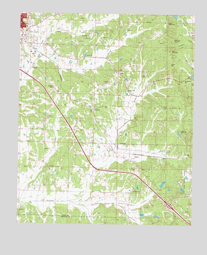
New Albany East, MS USGS Topographic Map
Click on map above to begin viewing in our Map Viewer.

This topographic map contains these locations and features:
Feature Name Type Latitude Longitude GNIS ID View Map
Adair CemeteryCemeteryN34.4857°W88.9526°683558View Map
Baker CemeteryCemeteryN34.4959°W88.9092°666470View Map
Beacon HillPopulated PlaceN34.4570°W88.9759°666624View Map
Bell CemeteryCemeteryN34.4834°W88.8995°666776View Map
Blue CutGapN34.4145°W88.8792°706089View Map
Blue Springs Baptist ChurchChurchN34.4073°W88.8756°706090View Map
Blue Springs CemeteryCemeteryN34.4162°W88.8767°667324View Map
Briar MountainSummitN34.4784°W88.8917°683564View Map
Buncombe (historical)LocaleN34.4607°W88.8848°683565View Map
Buncombe HillSummitN34.4582°W88.8853°667787View Map
Caldwell CreekStreamN34.3879°W88.9287°667915View Map
Calvary United Methodist ChurchChurchN34.4845°W88.9990°683566View Map
Camp ArmstrongLocaleN34.4301°W88.8828°683567View Map
Carnell Lake DamDamN34.4734°W88.9834°682661View Map
Carr CemeteryCemeteryN34.4968°W88.9576°668089View Map
CenterPopulated PlaceN34.4659°W88.9270°668228View Map
Center Baptist ChurchChurchN34.4668°W88.9270°706091View Map
Center CemeteryCemeteryN34.4690°W88.9251°706092View Map
Center Lookout TowerTowerN34.4954°W88.8942°711215View Map
Center Volunteer Fire DepartmentBuildingN34.4675°W88.9256°2665885View Map
Coleman CemeteryCemeteryN34.4223°W88.9228°668676View Map
Daniel High SchoolSchoolN34.4865°W88.9981°706094View Map
Dunlap CemeteryCemeteryN34.4448°W88.8903°683572View Map
East Branch Okannatie CreekStreamN34.4101°W88.9362°669562View Map
Fairview Post Office (historical)Post OfficeN34.4037°W88.9765°712168View Map
Gibsonville (historical)LocaleN34.4112°W88.9181°683578View Map
Grubb HillSummitN34.4707°W88.8920°670757View Map
Henry CemeteryCemeteryN34.4193°W88.9809°671114View Map
Hopewell CemeteryCemeteryN34.4604°W88.9362°706099View Map
Hopewell ChurchChurchN34.4601°W88.9359°671440View Map
Lake LyndaReservoirN34.3802°W88.9003°683591View Map
Lake Lynda DamDamN34.3818°W88.9001°682617View Map
Lebanon CemeteryCemeteryN34.4748°W88.9523°672351View Map
Liberty Baptist ChurchChurchN34.4068°W88.9770°683587View Map
Liberty CemeteryCemeteryN34.4082°W88.9770°683588View Map
Liberty SchoolSchoolN34.4076°W88.9765°672473View Map
Long Lake DamDamN34.4951°W88.8867°682670View Map
Luke HillSummitN34.4390°W88.9142°672950View Map
Mattie Thompson Elementary SchoolSchoolN34.4937°W88.9992°711691View Map
Miears CemeteryCemeteryN34.4898°W88.9348°706106View Map
Mound CityPopulated PlaceN34.4523°W88.9189°673902View Map
Mount Gilead CemeteryCemeteryN34.4443°W88.8939°706107View Map
Mount Gillard ChurchChurchN34.4445°W88.8931°674009View Map
New Albany Post OfficePost OfficeN34.4813°W88.9983°712169View Map
New HarmonyPopulated PlaceN34.3940°W88.9198°674636View Map
New Harmony CemeteryCemeteryN34.4079°W88.9145°674637View Map
New Harmony School (historical)SchoolN34.3948°W88.9181°706112View Map
Newtons Lake DamDamN34.4001°W88.8784°682629View Map
North Branch King CreekStreamN34.4754°W88.9834°674941View Map
Northside Baptist ChurchChurchN34.4970°W88.9959°683599View Map
Oak Grove ChurchChurchN34.4240°W88.9465°675061View Map
Okonatie Watershed UT-25-2 DamDamN34.3801°W88.9101°682614View Map
Oliver CemeteryCemeteryN34.3829°W88.9989°683601View Map
ParksPopulated PlaceN34.4907°W88.8759°675469View Map
Plentitude (historical)LocaleN34.4048°W88.9617°683605View Map
Poplar Springs CreekStreamN34.3889°W88.9625°2570603View Map
Popular Springs CreekStreamN34.3890°W88.9626°676253View Map
Rakestraw MountainSummitN34.4854°W88.8898°676460View Map
Ralph Harris Pond DamDamN34.3968°W88.8817°682625View Map
ReesePopulated PlaceN34.4159°W88.8942°692167View Map
Shiloh SchoolSchoolN34.4237°W88.9940°677712View Map
Snider CemeteryCemeteryN34.4948°W88.9453°677962View Map
South Branch King CreekStreamN34.4754°W88.9834°677992View Map
Southeast Union Volunteer Fire Department Station 1 HeadquartersBuildingN34.3955°W88.9168°2665884View Map
Southeast Union Volunteer Fire Department Station 2BuildingN34.4533°W88.9740°2665975View Map
Stack CemeteryCemeteryN34.4912°W88.9228°678199View Map
Stone CemeteryCemeteryN34.4637°W88.9089°678308View Map
Supervisor District 3CivilN34.4234°W88.9826°712112View Map
Union HillPopulated PlaceN34.4865°W88.9520°692286View Map
Wallersville CemeteryCemeteryN34.4415°W88.9514°706121View Map
WallervillePopulated PlaceN34.4418°W88.9459°679291View Map
Wallerville Baptist ChurchChurchN34.4412°W88.9515°683618View Map
West Branch Okannatie CreekStreamN34.4101°W88.9364°679473View Map
Wiley CemeteryCemeteryN34.4670°W88.9873°679681View Map
Wilkins CemeteryCemeteryN34.4384°W88.9784°706123View Map
Wilkins ChurchChurchN34.4384°W88.9781°679692View Map
WOKM-FM (New Albany)TowerN34.3979°W88.8851°680262View Map

Note: Coordinates in the location and feature list above are referenced to NAD83 datum.


Copyright (C) 2008-2024 Ryan Niemi / Sunset Dynamics ... All Rights Reserved