TopoQuest Logo
Do you find TopoQuest useful?
Help keep TopoQuest running and adding new maps/features by donating!
Bitcoin:  19c7KJd3qBynnjoSw5npx9KScwjBe4ifkT
Litecoin:  LXs6TkuXGGXo1vDsWCkWVdjQX94eUKd6ui
Home View Maps Find Maps Find Places Resources & Links


New Albany West, Mississippi Topographic Map

USGS Map Title: New Albany West, MS
USGS Map MRC: 34089D1
DRG (GeoTIFF) Download: o34089d1.tif


Neighboring USGS Topographic Map Quads:


  Hickory Flat, MS  
34089E2
 

  Myrtle, MS  
34089E1
 

  Keownville, MS  
34088E8
 

  Etta, MS  
34089D2
 

  New Albany West, MS  
34089D1
 

  New Albany East, MS  
34088D8
 

  Thaxton, MS  
34089C2
 

  Northwest Pontotoc, MS  
34089C1
 

  Northeast Pontotoc, MS  
34088C8


Map MRC Location:

N35°
W90°
N35°
W89°
H8 H7 H6 H5 H4 H3 H2 H1
G8 G7 G6 G5 G4 G3 G2 G1
F8 F7 F6 F5 F4 F3 F2 F1
E8 E7 E6 E5 E4 E3 E2 E1
D8 D7 D6 D5 D4 D3 D2 D1
C8 C7 C6 C5 C4 C3 C2 C1
B8 B7 B6 B5 B4 B3 B2 B1
A8 A7 A6 A5 A4 A3 A2 A1
N34°
W90°
N34°
W89°

New Albany West, MS USGS 1:24K Topographic Map Preview:
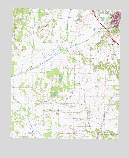
New Albany West, MS USGS Topographic Map
Click on map above to begin viewing in our Map Viewer.

This topographic map contains these locations and features:
Feature Name Type Latitude Longitude GNIS ID View Map
Alabama Street ParkParkN34.4970°W89.0015°683559View Map
Bald HillPopulated PlaceN34.4132°W89.0853°666480View Map
Baptist Memorial HospitalHospitalN34.4976°W89.0284°706120View Map
Bighams Mill (historical)LocaleN34.4043°W89.0362°683563View Map
Billy Ferrell Pond DamDamN34.4884°W89.0501°682666View Map
CairoPopulated PlaceN34.3779°W89.0431°706852View Map
Cairo ChurchChurchN34.3798°W89.0495°667909View Map
Camp BranchStreamN34.4832°W89.0209°667966View Map
Central Middle SchoolSchoolN34.4884°W89.0062°683568View Map
Church of ChristChurchN34.4668°W89.0087°683569View Map
City of New AlbanyCivilN34.4909°W89.0201°2404357View Map
Cleveland Street Presbyterian ChurchChurchN34.4948°W89.0051°683570View Map
Crone Lake DamDamN34.4184°W89.0634°682633View Map
Doctor E E Bramlitt Pond DamDamN34.4334°W89.0134°682639View Map
FairviewPopulated PlaceN34.4001°W89.0870°683576View Map
First Baptist ChurchChurchN34.4923°W89.0067°683574View Map
First United Methodist ChurchChurchN34.4923°W89.0056°683575View Map
Ford Elementary SchoolSchoolN34.4854°W89.0062°711690View Map
Fredonia ChurchChurchN34.4195°W89.0523°670177View Map
Harmony ChurchChurchN34.4834°W89.0901°683579View Map
Hell CreekStreamN34.4562°W89.0726°693447View Map
Hillcrest Baptist ChurchChurchN34.4759°W89.0017°683580View Map
IngomarPopulated PlaceN34.4093°W89.0367°671708View Map
Ingomar Baptist ChurchChurchN34.4109°W89.0387°683581View Map
Ingomar CemeteryCemeteryN34.3984°W89.0309°671709View Map
Ingomar SchoolSchoolN34.4087°W89.0428°706100View Map
Ingomar Volunteer Fire DepartmentBuildingN34.4103°W89.0184°2665978View Map
Jesse BranchStreamN34.3807°W89.0942°671866View Map
Jones CreekStreamN34.4090°W89.0995°671998View Map
King CreekStreamN34.4657°W89.0506°672155View Map
King Creek BottomsFlatN34.4584°W89.0334°706101View Map
Little Mud CreekStreamN34.4370°W89.1131°693772View Map
Lone Star SchoolSchoolN34.3815°W89.1134°672789View Map
Martin CemeteryCemeteryN34.4601°W89.0528°683592View Map
Martin ChurchChurchN34.4565°W89.0556°683593View Map
MartintownPopulated PlaceN34.4584°W89.0545°673200View Map
Martintown Recreational Lake DamDamN34.4301°W89.0701°682637View Map
Mississippi Highway Patrol District 4 Troop FBuildingN34.4828°W89.0335°2754307View Map
MitchellPopulated PlaceN34.4284°W89.0487°683594View Map
Mitchell SchoolSchoolN34.4259°W89.0481°673707View Map
Mosley Lake DamDamN34.4234°W89.0267°682636View Map
New AlbanyPopulated PlaceN34.4943°W89.0078°694153View Map
New Albany CemeteryCemeteryN34.4845°W89.0009°706111View Map
New Albany City HallBuildingN34.4932°W89.0106°683595View Map
New Albany Country ClubLocaleN34.4951°W89.0867°683596View Map
New Albany Fire Department Station 1 HeadquartersBuildingN34.4957°W89.0065°2665678View Map
New Albany Police DepartmentBuildingN34.4935°W89.0080°2754108View Map
New Albany Sewage Lagoon DamDamN34.4901°W89.0234°682667View Map
Oaks Country ClubLocaleN34.4318°W89.0137°683600View Map
Peck (historical)LocaleN34.4965°W89.0223°706115View Map
Pickett Lake DamDamN34.4918°W89.1067°682668View Map
Pleasant Grove CemeteryCemeteryN34.4234°W89.0387°675988View Map
Pleasant Grove ChurchChurchN34.4273°W89.0481°676043View Map
PoolvillePopulated PlaceN34.4676°W89.1201°676207View Map
Poolville ChurchChurchN34.4598°W89.1151°683606View Map
Saint Francis of Assisi Catholic ChurchChurchN34.4945°W89.0048°683611View Map
Saint Marys ChurchChurchN34.4893°W89.0445°683612View Map
Saint Marys SchoolSchoolN34.4895°W89.0428°677159View Map
Sand CreekStreamN34.3879°W89.0001°677336View Map
Shady Dell ParkParkN34.4832°W89.0084°683613View Map
Shady Grove ChurchChurchN34.3751°W89.1031°677593View Map
Stewarts ChapelChurchN34.4893°W89.0776°678289View Map
Terry CreekStreamN34.4262°W89.1234°678650View Map
Tywhiskey CreekStreamN34.4001°W89.1001°679022View Map
Union CountyCivilN34.4905°W89.0039°695793View Map
Union County CourthouseBuildingN34.4926°W89.0073°683615View Map
Union County Sheriff's OfficeBuildingN34.4911°W89.0111°2754162View Map
Union Hill CemeteryCemeteryN34.4840°W89.1142°683616View Map
Union Hill ChurchChurchN34.4879°W89.1165°679101View Map
Union SchoolSchoolN34.4832°W89.0884°679114View Map
Vista Memorial Park CemeteryCemeteryN34.4573°W89.0112°683617View Map
WNAU-AM (New Albany)TowerN34.4968°W89.0145°680165View Map
WOKM-FM (New Albany)TowerN34.4968°W89.0145°680264View Map
Zion ChapelChurchN34.4809°W89.0878°672725View Map

Note: Coordinates in the location and feature list above are referenced to NAD83 datum.


Copyright (C) 2008-2025 Ryan Niemi / Sunset Dynamics ... All Rights Reserved