TopoQuest Logo
Do you find TopoQuest useful?
Help keep TopoQuest running and adding new maps/features by donating!
Bitcoin:  19c7KJd3qBynnjoSw5npx9KScwjBe4ifkT
Litecoin:  LXs6TkuXGGXo1vDsWCkWVdjQX94eUKd6ui
Home View Maps Find Maps Find Places Resources & Links


Ketchum Reservoir, Oregon Topographic Map

USGS Map Title: Ketchum Reservoir, OR
USGS Map MRC: 45121E4
DRG (GeoTIFF) Download: o45121e4.tif


Neighboring USGS Topographic Map Quads:


  Hood River, OR  
45121F5
 

  White Salmon, WA  
45121F4
 

  Lyle, WA  
45121F3
 

  Parkdale, OR  
45121E5
 

  Ketchum Reservoir, OR  
45121E4
 

  Brown Creek, OR  
45121E3
 

  Dog River, OR  
45121D5
 

  Fivemile Butte, OR  
45121D4
 

  Wolf Run, OR  
45121D3


Map MRC Location:

N46°
W122°
N46°
W121°
H8 H7 H6 H5 H4 H3 H2 H1
G8 G7 G6 G5 G4 G3 G2 G1
F8 F7 F6 F5 F4 F3 F2 F1
E8 E7 E6 E5 E4 E3 E2 E1
D8 D7 D6 D5 D4 D3 D2 D1
C8 C7 C6 C5 C4 C3 C2 C1
B8 B7 B6 B5 B4 B3 B2 B1
A8 A7 A6 A5 A4 A3 A2 A1
N45°
W122°
N45°
W121°

Ketchum Reservoir, OR USGS 1:24K Topographic Map Preview:
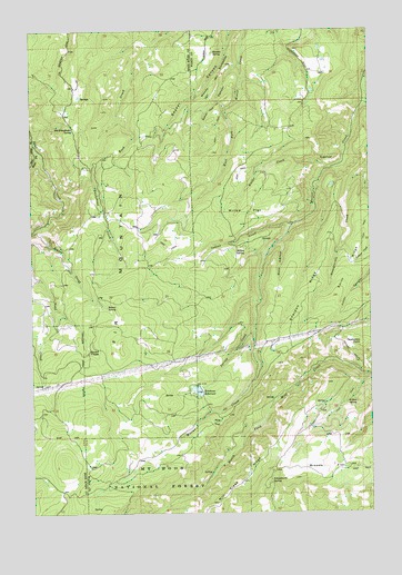
Ketchum Reservoir, OR USGS Topographic Map
Click on map above to begin viewing in our Map Viewer.

This topographic map contains these locations and features:
Feature Name Type Latitude Longitude GNIS ID View Map
Baker CanyonValleyN45.6154°W121.4234°1137423View Map
Beaver CreekStreamN45.5746°W121.4965°1137811View Map
Beaver SpringSpringN45.5533°W121.4731°1137849View Map
Breeds FlatFlatN45.5115°W121.3923°1138587View Map
Buck HollowValleyN45.5683°W121.4085°1138792View Map
Fir MountainSummitN45.5416°W121.4680°1142113View Map
Honeysuckle CreekStreamN45.6054°W121.3767°1143701View Map
Indian CreekStreamN45.5737°W121.4037°1144033View Map
Kellar CreekStreamN45.5890°W121.3904°1144513View Map
Ketchum DamDamN45.5323°W121.4390°1155584View Map
Ketchum RanchLocaleN45.5329°W121.4398°1156438View Map
Ketchum ReservoirReservoirN45.5316°W121.4404°1144578View Map
McVey SpringSpringN45.5681°W121.4228°1146036View Map
Mill Creek RidgeRidgeN45.5082°W121.4242°1146249View Map
Morden SpringSpringN45.6194°W121.4331°1146443View Map
Neal Creek LateralCanalN45.6235°W121.4984°1146742View Map
Old Schoolhouse SpringSpringN45.5998°W121.4850°1147207View Map
Pine FlatFlatN45.5229°W121.4348°1147708View Map
Round PrairieFlatN45.5429°W121.4804°1148798View Map
Saddle CampLocaleN45.5054°W121.3956°1638114View Map
Saddle SpringSpringN45.5285°W121.3935°1130070View Map
Schoolmarn SpringSpringN45.5075°W121.4135°1149144View Map
Sheldon RidgeRidgeN45.5554°W121.4001°1149367View Map
Sky Ranch Reservoir Number FourReservoirN45.6202°W121.3940°1161716View Map
Sky Ranch Reservoir Number ThreeReservoirN45.6091°W121.3970°1153279View Map
Smith RidgeRidgeN45.5623°W121.3845°1157001View Map
Snakehead CreekStreamN45.5843°W121.4915°1149791View Map
Spring CreekStreamN45.5468°W121.4184°1150171View Map
SugarloafSummitN45.5914°W121.3890°1150549View Map
Thompson PointSummitN45.5435°W121.3795°1151111View Map
West Fork Neal CreekStreamN45.5948°W121.4998°1152099View Map
Willow FlatFlatN45.5779°W121.4206°1152425View Map
Willow SpringSpringN45.5288°W121.3819°1152443View Map
Woods BackboneRidgeN45.6126°W121.4306°1152640View Map

Note: Coordinates in the location and feature list above are referenced to NAD83 datum.


Copyright (C) 2008-2025 Ryan Niemi / Sunset Dynamics ... All Rights Reserved