TopoQuest Logo
Do you find TopoQuest useful?
Help keep TopoQuest running and adding new maps/features by donating!
Bitcoin:  19c7KJd3qBynnjoSw5npx9KScwjBe4ifkT
Litecoin:  LXs6TkuXGGXo1vDsWCkWVdjQX94eUKd6ui
Home View Maps Find Maps Find Places Resources & Links


Kewaunee, Wisconsin Topographic Map

USGS Map Title: Kewaunee, WI
USGS Map MRC: 44087D5
DRG (GeoTIFF) Download: o44087d5.tif


Neighboring USGS Topographic Map Quads:


  Luxemburg, WI  
44087E6
 

  Casco, WI  
44087E5
 

  Algoma, WI  
44087E4
 

  Stangelville, WI  
44087D6
 

  Kewaunee, WI  
44087D5


  Larrabee, WI  
44087C6
 

  Two Creeks, WI  
44087C5


Map MRC Location:

N45°
W88°
N45°
W87°
H8 H7 H6 H5 H4 H3 H2 H1
G8 G7 G6 G5 G4 G3 G2 G1
F8 F7 F6 F5 F4 F3 F2 F1
E8 E7 E6 E5 E4 E3 E2 E1
D8 D7 D6 D5 D4 D3 D2 D1
C8 C7 C6 C5 C4 C3 C2 C1
B8 B7 B6 B5 B4 B3 B2 B1
A8 A7 A6 A5 A4 A3 A2 A1
N44°
W88°
N44°
W87°

Kewaunee, WI USGS 1:24K Topographic Map Preview:
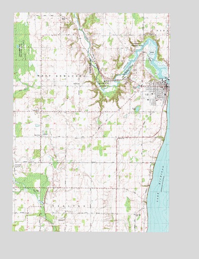
Kewaunee, WI USGS Topographic Map
Click on map above to begin viewing in our Map Viewer.

This topographic map contains these locations and features:
Feature Name Type Latitude Longitude GNIS ID View Map
BirchwoodPopulated PlaceN44.4581°W87.5715°1561817View Map
Bruemmer County ParkParkN44.4606°W87.5512°1562287View Map
Carlton School (historical)SchoolN44.3925°W87.5418°1840627View Map
City of KewauneeCivilN44.4603°W87.5110°1583475View Map
Community Congregational ChurchChurchN44.4550°W87.5062°1840630View Map
Dikeman School (historical)SchoolN44.4578°W87.6131°1840631View Map
East KrokPopulated PlaceN44.4289°W87.6023°1564340View Map
Elm Grove Dairy FarmLocaleN44.4956°W87.6086°2710541View Map
Footbridge School (historical)SchoolN44.4633°W87.5543°1840634View Map
Forest View CemeteryCemeteryN44.3853°W87.5262°1565142View Map
Halls Calf RanchLocaleN44.4719°W87.5228°2710549View Map
Hardtke FarmsLocaleN44.3861°W87.5539°2710542View Map
Holy Rosary Catholic ChurchChurchN44.4575°W87.5062°1840645View Map
Holy Rosary CemeteryCemeteryN44.4574°W87.5082°1840644View Map
Holy Rosary SchoolSchoolN44.4578°W87.5069°1840646View Map
Immanuel Evangelical Lutheran ChurchChurchN44.4525°W87.5098°1840649View Map
Immanuel Lutheran SchoolSchoolN44.4525°W87.5098°1840650View Map
KewauneePopulated PlaceN44.4583°W87.5031°1567445View Map
Kewaunee AmbulanceBuildingN44.4598°W87.5221°2698122View Map
Kewaunee County JailBuildingN44.4568°W87.5051°2759848View Map
Kewaunee County Sheriff's OfficeBuildingN44.4568°W87.5051°2759619View Map
Kewaunee Elementary SchoolSchoolN44.4522°W87.5177°2716282View Map
Kewaunee Fire DepartmentBuildingN44.4590°W87.5039°2697935View Map
Kewaunee High SchoolSchoolN44.4537°W87.5177°1840652View Map
Kewaunee Intermediate SchoolSchoolN44.4523°W87.5178°2716703View Map
Kewaunee Middle SchoolSchoolN44.4533°W87.5178°2716912View Map
Kewaunee Police DepartmentBuildingN44.4593°W87.5224°2759544View Map
Kewaunee River State Public Fishery AreaParkN44.4694°W87.5606°1567447View Map
Kewaunee State Public Hunting GroundsParkN44.4814°W87.6243°1567448View Map
Kewaunee Wastewater Treatment PlantLocaleN44.4625°W87.5050°2710345View Map
Lakeshore Alternative SchoolSchoolN44.4540°W87.5145°1840642View Map
Lakeshore Christian ChurchChurchN44.4536°W87.5176°1840653View Map
Little Scarboro State Public Hunting GroundsParkN44.4794°W87.6229°1568410View Map
Marquette Middle SchoolSchoolN44.4536°W87.5037°1840660View Map
Norman CemeteryCemeteryN44.3894°W87.6237°1840664View Map
Paplham DairyLocaleN44.3839°W87.5636°2710548View Map
Saint Hedwig Catholic ChurchChurchN44.4292°W87.6023°1840673View Map
Saint Hedwigs Catholic CemeteryCemeteryN44.4297°W87.6021°1840674View Map
Saint Marys Kewaunee Area Memorial Hospital HeliportAirportN44.4500°W87.5109°1582037View Map
Saint Peters CemeteryCemeteryN44.4119°W87.6237°1578072View Map
Saint Peters CemeteryCemeteryN44.4122°W87.6240°1840701View Map
Saint Peters ChurchChurchN44.4119°W87.6231°1573535View Map
Sano FarmsLocaleN44.4458°W87.5983°2710551View Map
Seidel LakeLakeN44.4452°W87.5259°1573893View Map
Siegmund FarmLocaleN44.4275°W87.5442°2710553View Map
Stangel FarmsLocaleN44.3867°W87.5275°2710554View Map
Stump PondLakeN44.4579°W87.5252°1574996View Map
Tess FarmLocaleN44.4272°W87.6142°2710550View Map
Thorn Apple CreekStreamN44.3908°W87.6004°2760476View Map
Town of West KewauneeCivilN44.4568°W87.5811°1584408View Map
Volunteer CemeteryCemeteryN44.4128°W87.6237°1576126View Map
WAUN-FM (Kewaunee)TowerN44.4972°W87.5865°1584521View Map
West Kewaunee Township CemeteryCemeteryN44.4597°W87.5149°1840706View Map

Note: Coordinates in the location and feature list above are referenced to NAD83 datum.


Copyright (C) 2008-2025 Ryan Niemi / Sunset Dynamics ... All Rights Reserved