TopoQuest Logo
Do you find TopoQuest useful?
Help keep TopoQuest running and adding new maps/features by donating!
Bitcoin:  19c7KJd3qBynnjoSw5npx9KScwjBe4ifkT
Litecoin:  LXs6TkuXGGXo1vDsWCkWVdjQX94eUKd6ui
Home View Maps Find Maps Find Places Resources & Links


Casco, Wisconsin Topographic Map

USGS Map Title: Casco, WI
USGS Map MRC: 44087E5
DRG (GeoTIFF) Download: o44087e5.tif


Neighboring USGS Topographic Map Quads:


  Namur, WI  
44087F6
 

  Brussels, WI  
44087F5
 

  Forestville, WI  
44087F4
 

  Luxemburg, WI  
44087E6
 

  Casco, WI  
44087E5
 

  Algoma, WI  
44087E4
 

  Stangelville, WI  
44087D6
 

  Kewaunee, WI  
44087D5


Map MRC Location:

N45°
W88°
N45°
W87°
H8 H7 H6 H5 H4 H3 H2 H1
G8 G7 G6 G5 G4 G3 G2 G1
F8 F7 F6 F5 F4 F3 F2 F1
E8 E7 E6 E5 E4 E3 E2 E1
D8 D7 D6 D5 D4 D3 D2 D1
C8 C7 C6 C5 C4 C3 C2 C1
B8 B7 B6 B5 B4 B3 B2 B1
A8 A7 A6 A5 A4 A3 A2 A1
N44°
W88°
N44°
W87°

Casco, WI USGS 1:24K Topographic Map Preview:
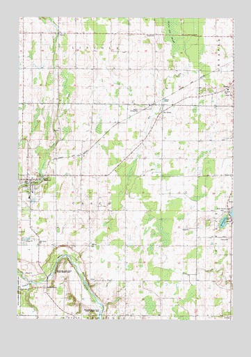
Casco, WI USGS Topographic Map
Click on map above to begin viewing in our Map Viewer.

This topographic map contains these locations and features:
Feature Name Type Latitude Longitude GNIS ID View Map
AlaskaPopulated PlaceN44.5406°W87.5012°1560724View Map
CascoPopulated PlaceN44.5578°W87.6181°1562762View Map
Casco MillpondReservoirN44.5581°W87.6111°1562764View Map
Casco Volunteer Fire DepartmentBuildingN44.5576°W87.6146°2697750View Map
Casco Wastewater Treatment PlantLocaleN44.5561°W87.6217°2710344View Map
ClydePopulated PlaceN44.5161°W87.5829°1577551View Map
El Na FarmsLocaleN44.5881°W87.5347°2710468View Map
EurenPopulated PlaceN44.6183°W87.6023°1564713View Map
GregorvillePopulated PlaceN44.6183°W87.5465°1577621View Map
Harvest AcresLocaleN44.5800°W87.5489°2710472View Map
Holy Trinity CemeteryCemeteryN44.5528°W87.6188°1840647View Map
Holy Trinity SchoolSchoolN44.5528°W87.6175°1840648View Map
Liberty School (historical)SchoolN44.6036°W87.5509°1840654View Map
Little Scarboro CreekStreamN44.5150°W87.6168°1568408View Map
Lonesome Road FarmsLocaleN44.5389°W87.5272°2710546View Map
Luxemburg - Casco Middle SchoolSchoolN44.5503°W87.6186°1840659View Map
Pavlat Dairy FarmsLocaleN44.5681°W87.5400°2710477View Map
Railside Dairy FarmLocaleN44.5678°W87.6017°2710493View Map
RankinPopulated PlaceN44.5961°W87.5034°1577784View Map
Riedy FarmsLocaleN44.5697°W87.5867°2710487View Map
Rio CreekPopulated PlaceN44.5892°W87.5412°1572331View Map
Rosebud School (historical)SchoolN44.5164°W87.5620°1840668View Map
RostokPopulated PlaceN44.5017°W87.5015°1572627View Map
Ryan School (historical)SchoolN44.5011°W87.5920°1840670View Map
Ryans CornerPopulated PlaceN44.5133°W87.6079°1577805View Map
Saint Adalberts CemeteryCemeteryN44.5303°W87.5826°1840671View Map
Saint Johns CemeteryCemeteryN44.5953°W87.5051°1573060View Map
Saint Johns Evangelical Lutheran ChurchChurchN44.5956°W87.5037°1840679View Map
SlovanPopulated PlaceN44.5308°W87.5831°1574283View Map
Strip Valley Dairy FarmsLocaleN44.6044°W87.5814°2710486View Map
Tebon Sand and Gravel PitMineN44.5217°W87.6217°2635549View Map
Teske FarmsLocaleN44.5456°W87.5042°2710479View Map
Thayse FarmsLocaleN44.6194°W87.5525°2710483View Map
Town of CascoCivilN44.5452°W87.5812°1582922View Map
Valley High FarmLocaleN44.5947°W87.5797°2710481View Map
Village of CascoCivilN44.5558°W87.6198°1582921View Map
Walter's Agri-Center AirportAirportN44.5861°W87.5576°1581048View Map
West Alaska LakeLakeN44.5406°W87.5059°1576132View Map
West Slovan CemeteryCemeteryN44.5308°W87.6123°1576561View Map
Wiesner CemeteryCemeteryN44.5602°W87.5003°1576720View Map

Note: Coordinates in the location and feature list above are referenced to NAD83 datum.


Copyright (C) 2008-2025 Ryan Niemi / Sunset Dynamics ... All Rights Reserved