TopoQuest Logo
Do you find TopoQuest useful?
Help keep TopoQuest running and adding new maps/features by donating!
Bitcoin:  19c7KJd3qBynnjoSw5npx9KScwjBe4ifkT
Litecoin:  LXs6TkuXGGXo1vDsWCkWVdjQX94eUKd6ui
Home View Maps Find Maps Find Places Resources & Links


Kilsock Island, South Carolina Topographic Map

USGS Map Title: Kilsock Island, SC
USGS Map MRC: 33079C4
DRG (GeoTIFF) Download: o33079c4.tif


Neighboring USGS Topographic Map Quads:


  Andrews, SC  
33079D5
 

  Olin, SC  
33079D4
 

  Georgetown North, SC  
33079D3
 

  Cedar Creek, SC  
33079C5
 

  Kilsock Island, SC  
33079C4
 

  Georgetown South, SC  
33079C3
 

  Honey Hill, SC  
33079B5
 

  South Santee, SC  
33079B4
 

  Minim Island, SC  
33079B3


Map MRC Location:

N34°
W80°
N34°
W79°
H8 H7 H6 H5 H4 H3 H2 H1
G8 G7 G6 G5 G4 G3 G2 G1
F8 F7 F6 F5 F4 F3 F2 F1
E8 E7 E6 E5 E4 E3 E2 E1
D8 D7 D6 D5 D4 D3 D2 D1
C8 C7 C6 C5 C4 C3 C2 C1
B8 B7 B6 B5 B4 B3 B2 B1
A8 A7 A6 A5 A4 A3 A2 A1
N33°
W80°
N33°
W79°

Kilsock Island, SC USGS 1:24K Topographic Map Preview:
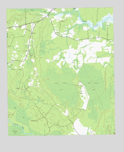
Kilsock Island, SC USGS Topographic Map
Click on map above to begin viewing in our Map Viewer.

This topographic map contains these locations and features:
Feature Name Type Latitude Longitude GNIS ID View Map
Big Kilsock BaySwampN33.2942°W79.3938°1246882View Map
Boggy SwampStreamN33.3721°W79.4203°1220871View Map
Britt BranchStreamN33.3729°W79.4667°1220966View Map
Britton NeckCapeN33.2807°W79.4662°1229456View Map
Cedar CreekStreamN33.2527°W79.4728°1247199View Map
CumberlandPopulated PlaceN33.3627°W79.4348°1231209View Map
Cumberland ChurchChurchN33.3627°W79.4348°1232301View Map
Cumberland ChurchChurchN33.3502°W79.4420°1247464View Map
Cumberland School (historical)SchoolN33.3499°W79.4417°1232302View Map
Foster CornerPopulated PlaceN33.3207°W79.4248°1231294View Map
Friendship ChurchChurchN33.2971°W79.4865°1222571View Map
Kilsock IslandIslandN33.2921°W79.4139°1223731View Map
Little Kilsock BaySwampN33.2993°W79.4352°1246406View Map
Lodge HallPopulated PlaceN33.3329°W79.4745°1224095View Map
New HopePopulated PlaceN33.3507°W79.4709°1224978View Map
New Hope ChurchChurchN33.3504°W79.4712°1232414View Map
New Hope School (historical)SchoolN33.3479°W79.4723°1232415View Map
Saint Paul ChurchChurchN33.3291°W79.4720°1250642View Map
SampitPopulated PlaceN33.3641°W79.4587°1231765View Map
Sampit ChurchChurchN33.3641°W79.4584°1232467View Map
Sampit Elementary SchoolSchoolN33.3634°W79.4466°1232468View Map
Sampit Lookout TowerTowerN33.3574°W79.4851°1232469View Map
Sampit ParkParkN33.3293°W79.4734°1232470View Map
Spring GullyStreamN33.3721°W79.4203°1226818View Map
Woodstock PlantationLocaleN33.3602°W79.3823°1232511View Map

Note: Coordinates in the location and feature list above are referenced to NAD83 datum.


Copyright (C) 2008-2024 Ryan Niemi / Sunset Dynamics ... All Rights Reserved