TopoQuest Logo
Do you find TopoQuest useful?
Help keep TopoQuest running and adding new maps/features by donating!
Bitcoin:  19c7KJd3qBynnjoSw5npx9KScwjBe4ifkT
Litecoin:  LXs6TkuXGGXo1vDsWCkWVdjQX94eUKd6ui
Home View Maps Find Maps Find Places Resources & Links


South Santee, South Carolina Topographic Map

USGS Map Title: South Santee, SC
USGS Map MRC: 33079B4
DRG (GeoTIFF) Download: o33079b4.tif


Neighboring USGS Topographic Map Quads:


  Cedar Creek, SC  
33079C5
 

  Kilsock Island, SC  
33079C4
 

  Georgetown South, SC  
33079C3
 

  Honey Hill, SC  
33079B5
 

  South Santee, SC  
33079B4
 

  Minim Island, SC  
33079B3
 

  Awendaw, SC  
33079A5
 

  McClellanville, SC  
33079A4
 

  Cape Romain, SC  
33079A3


Map MRC Location:

N34°
W80°
N34°
W79°
H8 H7 H6 H5 H4 H3 H2 H1
G8 G7 G6 G5 G4 G3 G2 G1
F8 F7 F6 F5 F4 F3 F2 F1
E8 E7 E6 E5 E4 E3 E2 E1
D8 D7 D6 D5 D4 D3 D2 D1
C8 C7 C6 C5 C4 C3 C2 C1
B8 B7 B6 B5 B4 B3 B2 B1
A8 A7 A6 A5 A4 A3 A2 A1
N33°
W80°
N33°
W79°

South Santee, SC USGS 1:24K Topographic Map Preview:
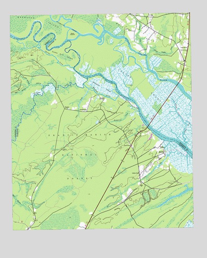
South Santee, SC USGS Topographic Map
Click on map above to begin viewing in our Map Viewer.

This topographic map contains these locations and features:
Feature Name Type Latitude Longitude GNIS ID View Map
Awendaw Fire District Station 6BuildingN33.1622°W79.4129°2368391View Map
Big Morgan BranchStreamN33.2088°W79.4776°1229422View Map
Bonny Clabber CreekStreamN33.2260°W79.4056°1229446View Map
Bouman BranchStreamN33.1854°W79.4270°1252695View Map
Cedar CreekStreamN33.2057°W79.4428°1229530View Map
Cedar HillSummitN33.2263°W79.4878°1231147View Map
Cedar Hill IslandIslandN33.2263°W79.4623°1229535View Map
Chicken CreekStreamN33.2193°W79.4567°1231166View Map
Collins CreekStreamN33.1677°W79.3778°1229580View Map
Collins CreekPopulated PlaceN33.1574°W79.4106°1231185View Map
Crow HillPopulated PlaceN33.2160°W79.3901°1232299View Map
Daniels IslandIslandN33.2274°W79.4162°1244071View Map
Elmwood Hunt CampLocaleN33.1979°W79.4703°1251614View Map
Fairfield PlantationLocaleN33.1827°W79.4045°1252833View Map
Fawn Hill School (historical)SchoolN33.2404°W79.3762°1232315View Map
Garfish CreekStreamN33.1860°W79.3795°1247872View Map
Georgetown Fire Department Station 2BuildingN33.2400°W79.3997°2368402View Map
GermantownPopulated PlaceN33.1954°W79.4473°1231311View Map
Germantown ChurchChurchN33.1938°W79.4484°1252881View Map
Germanville School (historical)SchoolN33.1938°W79.4473°1252882View Map
Goat IslandIslandN33.2379°W79.4573°1229735View Map
Hampton CreekStreamN33.2032°W79.4251°1229770View Map
Hampton IslandIslandN33.2077°W79.4370°1229771View Map
Hampton PlantationLocaleN33.2013°W79.4353°1229772View Map
Hampton Plantation State ParkParkN33.1996°W79.4409°1230568View Map
Harrietta PlantationLocaleN33.1693°W79.3939°1229777View Map
Hopsewee PlantationLocaleN33.2168°W79.3984°1232358View Map
John T Stevens Memorial BridgeBridgeN33.1849°W79.4051°1232373View Map
Little Morgan BranchStreamN33.2096°W79.4867°1229926View Map
Lynches Ferry (historical)CrossingN33.2157°W79.4003°1251714View Map
Mazycks Ferry (historical)CrossingN33.2007°W79.4178°1232522View Map
Montgomery CreekStreamN33.1932°W79.4117°1230033View Map
Moss Swamp School (historical)SchoolN33.1254°W79.4898°1253024View Map
Mount Zion CemeteryCemeteryN33.2490°W79.4006°1232407View Map
Mount Zion ChurchChurchN33.2488°W79.4006°1249704View Map
Mount Zion School (historical)SchoolN33.2482°W79.4003°1232409View Map
North SanteePopulated PlaceN33.2302°W79.3767°1230109View Map
Pole BranchStreamN33.2268°W79.4064°1230186View Map
Push and Go CreekGutN33.2116°W79.4153°1244072View Map
Saint James ChurchChurchN33.1718°W79.4656°1250516View Map
Saint James ChurchChurchN33.1560°W79.4120°1253184View Map
Sampit-North Santee DivisionCivilN33.2474°W79.3857°1938413View Map
Santee ParkParkN33.2474°W79.3970°1232473View Map
Santee RiverStreamN33.2352°W79.4595°1250783View Map
Santee SchoolSchoolN33.2016°W79.3903°1230303View Map
Santee School (historical)SchoolN33.1849°W79.4273°1253224View Map
Singleton African Methodist Episcopal ChurchChurchN33.2304°W79.3773°1232477View Map
South SanteePopulated PlaceN33.1735°W79.4176°1230348View Map
Wadmacon CreekStreamN33.2385°W79.4517°1253487View Map
Wambaw CornerPopulated PlaceN33.1954°W79.4631°1231890View Map
Wambaw CreekStreamN33.2132°W79.4470°1230457View Map
Washo ReserveSwampN33.1474°W79.3781°1227800View Map
Water Horn Ferry (historical)CrossingN33.2071°W79.4687°1234666View Map
Waterhorn Historical AreaLocaleN33.2116°W79.4526°1230585View Map
Wedge PlantationLocaleN33.1721°W79.3978°1251349View Map

Note: Coordinates in the location and feature list above are referenced to NAD83 datum.


Copyright (C) 2008-2025 Ryan Niemi / Sunset Dynamics ... All Rights Reserved