TopoQuest Logo
Do you find TopoQuest useful?
Help keep TopoQuest running and adding new maps/features by donating!
Bitcoin:  19c7KJd3qBynnjoSw5npx9KScwjBe4ifkT
Litecoin:  LXs6TkuXGGXo1vDsWCkWVdjQX94eUKd6ui
Home View Maps Find Maps Find Places Resources & Links


Cedar Creek, South Carolina Topographic Map

USGS Map Title: Cedar Creek, SC
USGS Map MRC: 33079C5
DRG (GeoTIFF) Download: o33079c5.tif


Neighboring USGS Topographic Map Quads:


  Trio, SC  
33079D6
 

  Andrews, SC  
33079D5
 

  Olin, SC  
33079D4
 

  Jamestown, SC  
33079C6
 

  Cedar Creek, SC  
33079C5
 

  Kilsock Island, SC  
33079C4
 

  Shulerville, SC  
33079B6
 

  Honey Hill, SC  
33079B5
 

  South Santee, SC  
33079B4


Map MRC Location:

N34°
W80°
N34°
W79°
H8 H7 H6 H5 H4 H3 H2 H1
G8 G7 G6 G5 G4 G3 G2 G1
F8 F7 F6 F5 F4 F3 F2 F1
E8 E7 E6 E5 E4 E3 E2 E1
D8 D7 D6 D5 D4 D3 D2 D1
C8 C7 C6 C5 C4 C3 C2 C1
B8 B7 B6 B5 B4 B3 B2 B1
A8 A7 A6 A5 A4 A3 A2 A1
N33°
W80°
N33°
W79°

Cedar Creek, SC USGS 1:24K Topographic Map Preview:
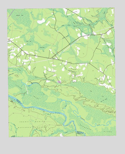
Cedar Creek, SC USGS Topographic Map
Click on map above to begin viewing in our Map Viewer.

This topographic map contains these locations and features:
Feature Name Type Latitude Longitude GNIS ID View Map
Big HillRidgeN33.2959°W79.5659°1229420View Map
Bino BaySwampN33.3429°W79.6001°1229426View Map
Canaan BaySwampN33.3341°W79.5919°1247132View Map
Canaan BranchStreamN33.3574°W79.5462°1229508View Map
Cedar Creek School (historical)SchoolN33.3302°W79.6017°1232285View Map
Crabapple BranchStreamN33.3141°W79.6120°1229603View Map
Dawhoo LakeLakeN33.3005°W79.5988°1229625View Map
Ditch BranchStreamN33.3585°W79.5548°1229638View Map
Doe LandingLocaleN33.2782°W79.6065°1234296View Map
Echaw CreekStreamN33.2557°W79.5473°1229675View Map
Foot Log SloughGutN33.2852°W79.5131°1229709View Map
Fosters LandingLocaleN33.2541°W79.5467°1252149View Map
Gal BranchStreamN33.2502°W79.5998°1229724View Map
Georgetown Fire Department Station 7BuildingN33.3281°W79.5682°2368294View Map
Guilliard LakeLakeN33.2859°W79.6193°1229759View Map
Guilliard Lake Recreation SiteLocaleN33.2866°W79.6201°1230569View Map
Jack HillRidgeN33.2745°W79.5129°1229844View Map
LambertPopulated PlaceN33.3260°W79.5723°1246284View Map
Mackey BaySwampN33.3640°W79.6045°1229968View Map
Mill CreekStreamN33.2732°W79.5745°1230008View Map
Price LandingPopulated PlaceN33.2746°W79.5812°1231688View Map
Prices LandingLocaleN33.2604°W79.5606°1234364View Map
Put-on BranchStreamN33.2529°W79.5387°1230206View Map
Saint Paul School (historical)SchoolN33.3560°W79.5009°1232462View Map
Saints Delight ChurchChurchN33.3282°W79.5706°1232464View Map
Santee SwampSwampN33.2869°W79.5870°1230304View Map
Summons SwampStreamN33.3660°W79.5117°1230385View Map
The CutoffStreamN33.2724°W79.5598°1230403View Map
Trinity Lutheran ChurchChurchN33.3224°W79.5542°1251205View Map
Wadmacon IslandIslandN33.2513°W79.5062°1230447View Map
Wilkes BranchStreamN33.3029°W79.5448°1230500View Map

Note: Coordinates in the location and feature list above are referenced to NAD83 datum.


Copyright (C) 2008-2025 Ryan Niemi / Sunset Dynamics ... All Rights Reserved