TopoQuest Logo
Do you find TopoQuest useful?
Help keep TopoQuest running and adding new maps/features by donating!
Bitcoin:  19c7KJd3qBynnjoSw5npx9KScwjBe4ifkT
Litecoin:  LXs6TkuXGGXo1vDsWCkWVdjQX94eUKd6ui
Home View Maps Find Maps Find Places Resources & Links


Honey Hill, South Carolina Topographic Map

USGS Map Title: Honey Hill, SC
USGS Map MRC: 33079B5
DRG (GeoTIFF) Download: o33079b5.tif


Neighboring USGS Topographic Map Quads:


  Jamestown, SC  
33079C6
 

  Cedar Creek, SC  
33079C5
 

  Kilsock Island, SC  
33079C4
 

  Shulerville, SC  
33079B6
 

  Honey Hill, SC  
33079B5
 

  South Santee, SC  
33079B4
 

  Ocean Bay, SC  
33079A6
 

  Awendaw, SC  
33079A5
 

  McClellanville, SC  
33079A4


Map MRC Location:

N34°
W80°
N34°
W79°
H8 H7 H6 H5 H4 H3 H2 H1
G8 G7 G6 G5 G4 G3 G2 G1
F8 F7 F6 F5 F4 F3 F2 F1
E8 E7 E6 E5 E4 E3 E2 E1
D8 D7 D6 D5 D4 D3 D2 D1
C8 C7 C6 C5 C4 C3 C2 C1
B8 B7 B6 B5 B4 B3 B2 B1
A8 A7 A6 A5 A4 A3 A2 A1
N33°
W80°
N33°
W79°

Honey Hill, SC USGS 1:24K Topographic Map Preview:
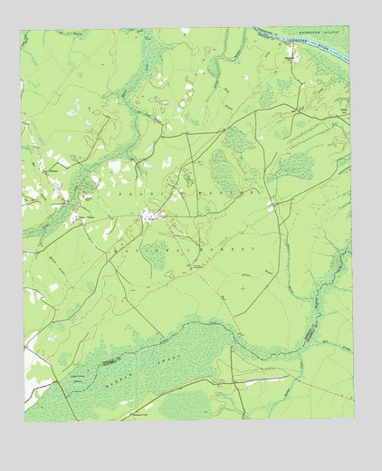
Honey Hill, SC USGS Topographic Map
Click on map above to begin viewing in our Map Viewer.

This topographic map contains these locations and features:
Feature Name Type Latitude Longitude GNIS ID View Map
Bay BranchStreamN33.1891°W79.6128°1229381View Map
Beaman BranchStreamN33.1868°W79.6159°1229385View Map
Buck BranchStreamN33.2327°W79.5501°1229473View Map
Cane BranchStreamN33.1638°W79.5134°1229513View Map
Charley BridgesLocaleN33.1902°W79.6037°1229547View Map
Charlie BridgesBridgeN33.1946°W79.6070°1234461View Map
Coffee Creek SwampSwampN33.1388°W79.6045°1229571View Map
Coffey Bridges (historical)BridgeN33.1504°W79.5703°1234468View Map
Green Bay (historical)Populated PlaceN33.2202°W79.6223°1234502View Map
Honey HillPopulated PlaceN33.1904°W79.5756°1229812View Map
Honey Hill Hunt CampLocaleN33.1743°W79.5623°1230584View Map
Honey Hill Lookout TowerTowerN33.1735°W79.5612°1242407View Map
Honey Hill School (historical)SchoolN33.1896°W79.5784°1234524View Map
June Pond StrandStreamN33.2235°W79.5820°1229874View Map
Keepers BranchStreamN33.1657°W79.5240°1229875View Map
Mechaw CreekStreamN33.1468°W79.5206°1229995View Map
Mill BranchStreamN33.1521°W79.5159°1230004View Map
Mount Zion ChurchChurchN33.1893°W79.5781°1234561View Map
NewlandPopulated PlaceN33.2043°W79.6162°1230102View Map
Palmer BridgesBridgeN33.1499°W79.5442°1234583View Map
Pitch LandingPopulated PlaceN33.2468°W79.5778°1231667View Map
Pleasant HillSummitN33.2404°W79.5201°1230181View Map
Pleasant Hill LandingPopulated PlaceN33.2452°W79.5209°1231671View Map
Pole BranchStreamN33.1968°W79.6173°1230188View Map
Red Bluff CreekStreamN33.2332°W79.5028°1250301View Map
Shulerville Honey Hill Fire DepartmentBuildingN33.1997°W79.6167°2368348View Map
Thompson BridgesBridgeN33.1382°W79.6123°1234646View Map
Thompson CornerPopulated PlaceN33.1271°W79.5845°1230408View Map
Velvet BranchStreamN33.2457°W79.5251°1230443View Map
Vigilant ChurchChurchN33.1999°W79.6237°1234654View Map
Vigilant School (historical)SchoolN33.2104°W79.6184°1234655View Map
Wambaw Creek WildernessReserveN33.1783°W79.5012°2035335View Map
Wambaw SwampSwampN33.1427°W79.5783°1230458View Map
Wanbaw Creek WildernessReserveN33.1746°W79.5001°1230565View Map
Washington School (historical)SchoolN33.2043°W79.5598°1234661View Map
Wesley ChurchChurchN33.1896°W79.6037°1234667View Map
Wesley SchoolSchoolN33.1960°W79.6009°1230476View Map

Note: Coordinates in the location and feature list above are referenced to NAD83 datum.


Copyright (C) 2008-2024 Ryan Niemi / Sunset Dynamics ... All Rights Reserved