TopoQuest Logo
Do you find TopoQuest useful?
Help keep TopoQuest running and adding new maps/features by donating!
Bitcoin:  19c7KJd3qBynnjoSw5npx9KScwjBe4ifkT
Litecoin:  LXs6TkuXGGXo1vDsWCkWVdjQX94eUKd6ui
Home View Maps Find Maps Find Places Resources & Links


Kinsley, California Topographic Map

USGS Map Title: Kinsley, CA
USGS Map MRC: 37119F8
DRG (GeoTIFF) Download: o37119f8.tif


Neighboring USGS Topographic Map Quads:


  Jawbone Ridge, CA  
37120G1
 

  Ascension Mountain, CA  
37119G8
 

  Ackerson Mountain, CA  
37119G7
 

  Buckhorn Peak, CA  
37120F1
 

  Kinsley, CA  
37119F8
 

  El Portal, CA  
37119F7
 

  Bear Valley, CA  
37120E1
 

  Feliciana Mountain, CA  
37119E8
 

  Buckingham Mountain, CA  
37119E7


Map MRC Location:

N38°
W120°
N38°
W119°
H8 H7 H6 H5 H4 H3 H2 H1
G8 G7 G6 G5 G4 G3 G2 G1
F8 F7 F6 F5 F4 F3 F2 F1
E8 E7 E6 E5 E4 E3 E2 E1
D8 D7 D6 D5 D4 D3 D2 D1
C8 C7 C6 C5 C4 C3 C2 C1
B8 B7 B6 B5 B4 B3 B2 B1
A8 A7 A6 A5 A4 A3 A2 A1
N37°
W120°
N37°
W119°

Kinsley, CA USGS 1:24K Topographic Map Preview:
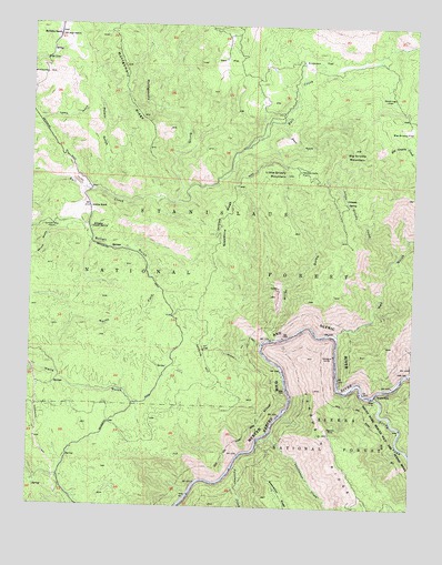
Kinsley, CA USGS Topographic Map
Click on map above to begin viewing in our Map Viewer.

This topographic map contains these locations and features:
Feature Name Type Latitude Longitude GNIS ID View Map
Anderson FlatFlatN37.7410°W119.9082°256237View Map
Big Grizzly FlatFlatN37.7238°W119.8788°256939View Map
Big Grizzly MountainSummitN37.7180°W119.8960°256940View Map
Bonell GulchValleyN37.7005°W119.9821°257339View Map
Deer FlatFlatN37.7408°W119.9393°259229View Map
Domingo FlatFlatN37.7324°W119.8846°259464View Map
Feliciana CreekStreamN37.6349°W119.9343°266701View Map
Ferguson DumpLocaleN37.6455°W119.9018°260079View Map
Ferguson RidgeRidgeN37.6413°W119.9010°260080View Map
Garibaldi MineMineN37.6977°W119.9941°260483View Map
Hayden Cabin Interpretive SiteBuildingN37.6354°W119.9629°2547623View Map
Jenkins HillSummitN37.6627°W119.9441°1658855View Map
Jenkins Hill TrailTrailN37.6655°W119.9321°261923View Map
Jenkins RanchLocaleN37.7024°W119.9821°261924View Map
KinsleyLocaleN37.6969°W119.9818°262197View Map
Little Grizzly CreekStreamN37.6899°W119.8816°262618View Map
Little Grizzly FlatFlatN37.7113°W119.9130°227267View Map
Little Grizzly MountainSummitN37.7119°W119.9182°262623View Map
McCauley HillSummitN37.7366°W119.9971°1659083View Map
McCauley RanchLocaleN37.7471°W119.9930°263310View Map
Miller GulchValleyN37.6685°W119.9218°263633View Map
Montgomery GulchValleyN37.7042°W119.9537°263773View Map
Ned GulchValleyN37.6697°W119.9015°264016View Map
North Fork Halls GulchValleyN37.6594°W119.9918°264169View Map
Paps GulchValleyN37.7247°W119.9205°264503View Map
Porath GulchValleyN37.7072°W119.9821°264953View Map
Savage Trading PostBuildingN37.6541°W119.8877°1809298View Map
Skunk GulchValleyN37.7016°W119.9846°266247View Map
Soapstone RidgeRidgeN37.6985°W119.9391°267354View Map
South ForkLocaleN37.6541°W119.8871°267418View Map
South Fork Merced RiverStreamN37.6538°W119.8888°267477View Map
Sweetwater CreekStreamN37.6427°W119.9260°268026View Map

Note: Coordinates in the location and feature list above are referenced to NAD83 datum.


Copyright (C) 2008-2025 Ryan Niemi / Sunset Dynamics ... All Rights Reserved