TopoQuest Logo
Do you find TopoQuest useful?
Help keep TopoQuest running and adding new maps/features by donating!
Bitcoin:  19c7KJd3qBynnjoSw5npx9KScwjBe4ifkT
Litecoin:  LXs6TkuXGGXo1vDsWCkWVdjQX94eUKd6ui
Home View Maps Find Maps Find Places Resources & Links


Kishwaukee, Illinois Topographic Map

USGS Map Title: Kishwaukee, IL
USGS Map MRC: 42089B2
DRG (GeoTIFF) Download: o42089b2.tif


Neighboring USGS Topographic Map Quads:


  Pecatonica, IL  
42089C3
 

  Winnebago, IL  
42089C2
 

  Rockford North, IL  
42089C1
 

  Seward, IL  
42089B3
 

  Kishwaukee, IL  
42089B2
 

  Rockford South, IL  
42089B1
 

  Oregon, IL  
42089A3
 

  Stillman Valley, IL  
42089A2
 

  Kings, IL  
42089A1


Map MRC Location:

N43°
W90°
N43°
W89°
H8 H7 H6 H5 H4 H3 H2 H1
G8 G7 G6 G5 G4 G3 G2 G1
F8 F7 F6 F5 F4 F3 F2 F1
E8 E7 E6 E5 E4 E3 E2 E1
D8 D7 D6 D5 D4 D3 D2 D1
C8 C7 C6 C5 C4 C3 C2 C1
B8 B7 B6 B5 B4 B3 B2 B1
A8 A7 A6 A5 A4 A3 A2 A1
N42°
W90°
N42°
W89°

Kishwaukee, IL USGS 1:24K Topographic Map Preview:
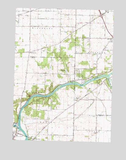
Kishwaukee, IL USGS Topographic Map
Click on map above to begin viewing in our Map Viewer.

This topographic map contains these locations and features:
Feature Name Type Latitude Longitude GNIS ID View Map
AlworthPopulated PlaceN42.2436°W89.2457°422405View Map
Bishops Lane Retreat HouseLocaleN42.1917°W89.1851°404477View Map
Brewster HeightsPopulated PlaceN42.2217°W89.1271°1829278View Map
Camp Medill McCormickLocaleN42.1631°W89.2198°405485View Map
Cecka Mobile Home ParkPopulated PlaceN42.1864°W89.1536°2628260View Map
Centerville SchoolSchoolN42.2375°W89.1584°405851View Map
Douglas E Wade Nature PreserveParkN42.1325°W89.2082°2013742View Map
Elida Post Office (historical)Post OfficeN42.2086°W89.2315°1811282View Map
Evergreen Covenant ChurchChurchN42.2236°W89.1265°1829304View Map
Evergreen SchoolSchoolN42.2228°W89.1284°408130View Map
Faith AcademySchoolN42.2236°W89.1271°1829306View Map
Grant View HeightsPopulated PlaceN42.1917°W89.1379°1829313View Map
Hickory CreekPopulated PlaceN42.2211°W89.1584°1829323View Map
Hinchcliff Memorial Forest PreserveParkN42.1842°W89.1323°1829504View Map
Howard D Colman Dells Nature PreserveParkN42.2064°W89.1943°2054037View Map
KishwaukeePopulated PlaceN42.1650°W89.1501°422882View Map
Kishwaukee CemeteryCemeteryN42.1636°W89.1690°411554View Map
Kishwaukee Community Presbyterian ChurchChurchN42.1642°W89.1487°1829522View Map
Kishwaukee RiverStreamN42.1861°W89.1312°411555View Map
Kishwaukee SchoolSchoolN42.1642°W89.1479°1705972View Map
Lake LouiseLakeN42.1387°W89.2472°412680View Map
Levi and Esther Fuller Forest PreserveParkN42.1895°W89.1676°411960View Map
Lindskolds SubdivisionPopulated PlaceN42.2067°W89.1426°1829344View Map
Loose Pulley JunctionPopulated PlaceN42.1261°W89.2240°422921View Map
Maple Corners School (historical)SchoolN42.2397°W89.2304°1705973View Map
Motor HeightsPopulated PlaceN42.1895°W89.1376°1829366View Map
Oak Grove SchoolSchoolN42.1989°W89.1454°414813View Map
Oakland School (historical)SchoolN42.1889°W89.1887°1705898View Map
Pinehurst FarmsLocaleN42.2459°W89.1379°1829379View Map
Rockford Mobile Home ParkPopulated PlaceN42.1864°W89.1631°2628264View Map
Severson Dells Nature PreserveParkN42.2061°W89.1976°2054043View Map
Severson-Dells Forest PreserveParkN42.2097°W89.2023°1811329View Map
Stillman CreekStreamN42.1261°W89.2309°419140View Map
Stillman School (historical)SchoolN42.1353°W89.2129°1705900View Map
Thrifty Acres AirportAirportN42.1446°W89.2280°2679089View Map
Township of WinnebagoCivilN42.2473°W89.2268°429946View Map
Weldon School (historical)SchoolN42.2336°W89.1918°1705974View Map
Westfield CornersPopulated PlaceN42.2084°W89.2309°420961View Map
Winnebago CemeteryCemeteryN42.2425°W89.2326°421337View Map
Woodburn School (historical)SchoolN42.1789°W89.2357°1705899View Map
WoodcrestPopulated PlaceN42.1820°W89.1426°1829414View Map

Note: Coordinates in the location and feature list above are referenced to NAD83 datum.


Copyright (C) 2008-2024 Ryan Niemi / Sunset Dynamics ... All Rights Reserved