TopoQuest Logo
Do you find TopoQuest useful?
Help keep TopoQuest running and adding new maps/features by donating!
Bitcoin:  19c7KJd3qBynnjoSw5npx9KScwjBe4ifkT
Litecoin:  LXs6TkuXGGXo1vDsWCkWVdjQX94eUKd6ui
Home View Maps Find Maps Find Places Resources & Links


Knightstown, Indiana Topographic Map

USGS Map Title: Knightstown, IN
USGS Map MRC: 39085G5
DRG (GeoTIFF) Download: o39085g5.tif


Neighboring USGS Topographic Map Quads:


  Pendleton, IN  
39085H6
 

  Shirley, IN  
39085H5
 

  New Castle West, IN  
39085H4
 

  Cleveland, IN  
39085G6
 

  Knightstown, IN  
39085G5
 

  Dunreith, IN  
39085G4
 

  Morristown, IN  
39085F6
 

  Carthage, IN  
39085F5
 

  Mays, IN  
39085F4


Map MRC Location:

N40°
W86°
N40°
W85°
H8 H7 H6 H5 H4 H3 H2 H1
G8 G7 G6 G5 G4 G3 G2 G1
F8 F7 F6 F5 F4 F3 F2 F1
E8 E7 E6 E5 E4 E3 E2 E1
D8 D7 D6 D5 D4 D3 D2 D1
C8 C7 C6 C5 C4 C3 C2 C1
B8 B7 B6 B5 B4 B3 B2 B1
A8 A7 A6 A5 A4 A3 A2 A1
N39°
W86°
N39°
W85°

Knightstown, IN USGS 1:24K Topographic Map Preview:
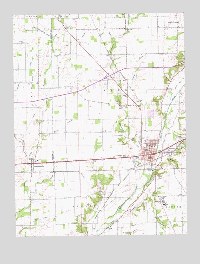
Knightstown, IN USGS Topographic Map
Click on map above to begin viewing in our Map Viewer.

This topographic map contains these locations and features:
Feature Name Type Latitude Longitude GNIS ID View Map
Anthony CreekStreamN39.7953°W85.6139°430192View Map
Beech Grove ChurchChurchN39.7612°W85.5791°430727View Map
Bell CemeteryCemeteryN39.7719°W85.5226°430755View Map
Bell RunStreamN39.7712°W85.5264°430771View Map
Bench RunStreamN39.8748°W85.5403°430795View Map
Bethel ChurchChurchN39.7939°W85.5280°430932View Map
Buck CreekStreamN39.8067°W85.5175°431718View Map
Carthage CemeteryCemeteryN39.7541°W85.5583°432195View Map
Castle LakeReservoirN39.8499°W85.5076°447677View Map
Central CreekStreamN39.8281°W85.5480°432353View Map
Central SchoolSchoolN39.8284°W85.5425°432366View Map
Charlottes BrookStreamN39.7712°W85.6139°432428View Map
CharlottesvillePopulated PlaceN39.7903°W85.6128°432430View Map
Charlottesville Volunteer Fire DepartmentBuildingN39.7917°W85.6108°2625786View Map
Eastern Hancock Elementary SchoolSchoolN39.7934°W85.6083°447049View Map
Eastern Hancock Junior-Senior High SchoolSchoolN39.7934°W85.6083°447048View Map
Glen RunStreamN39.8028°W85.5378°435108View Map
Glencove CemeteryCemeteryN39.8045°W85.5336°435109View Map
Grant CityPopulated PlaceN39.8664°W85.5425°435319View Map
Grant RunStreamN39.8570°W85.5516°435327View Map
HenryPopulated PlaceN39.7859°W85.5875°446674View Map
Hills West DamDamN39.8500°W85.5050°447676View Map
Indiana Soldiers and Sailors Childrens HomeSchoolN39.7712°W85.5183°449607View Map
KnightstownPopulated PlaceN39.7956°W85.5264°437394View Map
Knightstown Fire DepartmentBuildingN39.7946°W85.5249°2625935View Map
Knightstown High SchoolSchoolN39.8070°W85.5208°446598View Map
Knightstown Police DepartmentBuildingN39.7949°W85.5250°2758351View Map
KnoxPopulated PlaceN39.8231°W85.5419°437414View Map
Knox RunStreamN39.8434°W85.5350°437417View Map
Lizz Town CemeteryCemeteryN39.8741°W85.5913°2741298View Map
Maple ValleyPopulated PlaceN39.8670°W85.5869°438580View Map
Million BrookStreamN39.8064°W85.6053°439240View Map
Montgomery CreekStreamN39.7817°W85.5275°439364View Map
Morris CreekStreamN39.8364°W85.6194°439452View Map
Morton SchoolSchoolN39.7670°W85.5169°439476View Map
Perry BrookStreamN39.8598°W85.5961°441024View Map
Perry LakeLakeN39.8673°W85.6075°441031View Map
RaysvillePopulated PlaceN39.7962°W85.5125°441802View Map
Raysville RunStreamN39.7923°W85.5214°441803View Map
Ring RunStreamN39.8253°W85.5094°442049View Map
Saint Rose of Lima ChurchChurchN39.7948°W85.5441°442833View Map
Six Mile CemeteryCemeteryN39.8150°W85.6062°443562View Map
Small FieldAirportN39.7505°W85.5582°2677109View Map
Southwest Ambulance Service Emergency Medical ServiceBuildingN39.7998°W85.5118°2701476View Map
Sulphur SpringPopulated PlaceN39.7700°W85.5158°448342View Map
Threemile CreekStreamN39.7631°W85.5503°444745View Map
Town of KnightstownCivilN39.7959°W85.5312°2396694View Map
Township of WayneCivilN39.8295°W85.5447°454031View Map
Wallace Field Airport (historical)AirportN39.8625°W85.6025°2677068View Map
Willcox AirportAirportN39.8233°W85.5921°449227View Map
Wink DitchCanalN39.8556°W85.5878°446185View Map
York RunStreamN39.7767°W85.5358°446401View Map

Note: Coordinates in the location and feature list above are referenced to NAD83 datum.


Copyright (C) 2008-2025 Ryan Niemi / Sunset Dynamics ... All Rights Reserved