TopoQuest Logo
Do you find TopoQuest useful?
Help keep TopoQuest running and adding new maps/features by donating!
Bitcoin:  19c7KJd3qBynnjoSw5npx9KScwjBe4ifkT
Litecoin:  LXs6TkuXGGXo1vDsWCkWVdjQX94eUKd6ui
Home View Maps Find Maps Find Places Resources & Links


Kolob Arch, Utah Topographic Map

USGS Map Title: Kolob Arch, UT
USGS Map MRC: 37113D2
DRG (GeoTIFF) Download: o37113d2.tif


Neighboring USGS Topographic Map Quads:


  Stoddard Mountain, UT  
37113E3
 

  Kanarraville, UT  
37113E2
 

  Cedar Mountain, UT  
37113E1
 

  New Harmony, UT  
37113D3
 

  Kolob Arch, UT  
37113D2
 

  Kolob Reservoir, UT  
37113D1
 

  Pintura, UT  
37113C3
 

  Smith Mesa, UT  
37113C2
 

  The Guardian Angels, UT  
37113C1


Map MRC Location:

N38°
W114°
N38°
W113°
H8 H7 H6 H5 H4 H3 H2 H1
G8 G7 G6 G5 G4 G3 G2 G1
F8 F7 F6 F5 F4 F3 F2 F1
E8 E7 E6 E5 E4 E3 E2 E1
D8 D7 D6 D5 D4 D3 D2 D1
C8 C7 C6 C5 C4 C3 C2 C1
B8 B7 B6 B5 B4 B3 B2 B1
A8 A7 A6 A5 A4 A3 A2 A1
N37°
W114°
N37°
W113°

Kolob Arch, UT USGS 1:24K Topographic Map Preview:
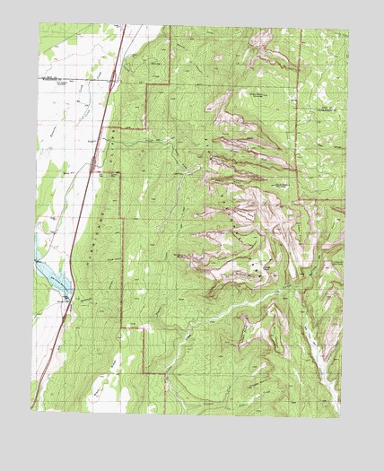
Kolob Arch, UT USGS Topographic Map
Click on map above to begin viewing in our Map Viewer.

This topographic map contains these locations and features:
Feature Name Type Latitude Longitude GNIS ID View Map
Ash Creek DamDamN37.4111°W113.2358°1434622View Map
Ash Creek ReservoirReservoirN37.4161°W113.2400°1434621View Map
Bear Trap CanyonValleyN37.4317°W113.1267°1425367View Map
Beatty PointCapeN37.4500°W113.1727°1425371View Map
Beatty SpringSpringN37.4158°W113.1469°1435102View Map
Buck Pasture MountainSummitN37.4494°W113.1540°1426055View Map
Burnt MountainSummitN37.4010°W113.1535°1426187View Map
Camp CreekStreamN37.5000°W113.2127°1426305View Map
Cane CreekStreamN37.3789°W113.1727°1426329View Map
Currant CreekStreamN37.3766°W113.1880°1427160View Map
Deadman HollowValleyN37.4100°W113.2337°1427257View Map
Death PointCapeN37.4375°W113.1433°1427281View Map
Epsolon MineMineN37.4519°W113.2208°1427833View Map
Fort Harmony MonumentParkN37.4803°W113.2427°1428040View Map
Gregory ButteSummitN37.4199°W113.1638°1428410View Map
Herbs PointCapeN37.4391°W113.1291°1428669View Map
Hop ValleyValleyN37.4168°W113.1447°1428814View Map
Hop Valley TrailTrailN37.3761°W113.1358°1450393View Map
Horse Ranch MountainSummitN37.4783°W113.1597°1428860View Map
Hurricane CliffsCliffN37.4039°W113.2252°1441959View Map
Kolob ArchArchN37.4236°W113.1577°1429390View Map
Kolob Arch TrailTrailN37.4197°W113.1502°1435831View Map
Kolob Canyon Road Terminus CampgroundLocaleN37.4355°W113.2011°1454788View Map
Kolob Canyons ViewpointLocaleN37.4355°W113.2013°1435832View Map
Kolob Canyons Visitor CenterLocaleN37.4536°W113.2255°1435833View Map
La Verkin Creek TrailTrailN37.4286°W113.1349°1435837View Map
Langston CanyonValleyN37.3917°W113.1327°1429472View Map
Larson CabinLocaleN37.4539°W113.1352°1429481View Map
Lee PassGapN37.4522°W113.1902°1429521View Map
Locust CreekStreamN37.4886°W113.2183°1429848View Map
Middle Fork Taylor CreekStreamN37.4619°W113.1836°1430282View Map
Nagunt MesaSummitN37.4409°W113.1693°1430631View Map
Neagle RidgeRidgeN37.3980°W113.1666°1430658View Map
New Harmony Fire Station - Kolob StationBuildingN37.4525°W113.2342°2627349View Map
North Fork Taylor CreekStreamN37.4619°W113.1836°1430811View Map
Old Fort Harmony (historical)LocaleN37.4805°W113.2433°1436066View Map
Pace KnollSummitN37.4242°W113.2160°1431061View Map
Paria PointCapeN37.4566°W113.1786°1431097View Map
Shuntavi ButteSummitN37.4259°W113.1901°1432432View Map
Smith CabinLocaleN37.4511°W113.1455°1432564View Map
South Fork Taylor CreekStreamN37.4630°W113.1955°1432715View Map
Stapley PointCapeN37.3844°W113.1586°1432916View Map
Taylor CreekStreamN37.4591°W113.2466°1433201View Map
Taylor Creek WildernessReserveN37.4543°W113.1436°2760131View Map
Timber CreekStreamN37.4003°W113.1886°1433526View Map
Timber Top MountainSummitN37.4240°W113.1792°1433530View Map
Tucupit PointCapeN37.4630°W113.1738°1433694View Map
Wayne CanyonValleyN37.4974°W113.2024°1434018View Map

Note: Coordinates in the location and feature list above are referenced to NAD83 datum.


Copyright (C) 2008-2025 Ryan Niemi / Sunset Dynamics ... All Rights Reserved