TopoQuest Logo
Do you find TopoQuest useful?
Help keep TopoQuest running and adding new maps/features by donating!
Bitcoin:  19c7KJd3qBynnjoSw5npx9KScwjBe4ifkT
Litecoin:  LXs6TkuXGGXo1vDsWCkWVdjQX94eUKd6ui
Home View Maps Find Maps Find Places Resources & Links


Lac du Flambeau, Wisconsin Topographic Map

USGS Map Title: Lac du Flambeau, WI
USGS Map MRC: 45089H8
DRG (GeoTIFF) Download: o45089h8.tif


Neighboring USGS Topographic Map Quads:


  Wilson Lake, WI  
46090A1
 

  Powell, WI  
46089A8
 

  Manitowish Lake, WI  
46089A7
 

  Pike Lake, WI  
45090H1
 

  Lac du Flambeau, WI  
45089H8
 

  Fence Lake, WI  
45089H7
 

  Pike Lake SE, WI  
45090G1
 

  Lac du Flambeau SW, WI  
45089G8
 

  Mercer Lake, WI  
45089G7


Map MRC Location:

N46°
W90°
N46°
W89°
H8 H7 H6 H5 H4 H3 H2 H1
G8 G7 G6 G5 G4 G3 G2 G1
F8 F7 F6 F5 F4 F3 F2 F1
E8 E7 E6 E5 E4 E3 E2 E1
D8 D7 D6 D5 D4 D3 D2 D1
C8 C7 C6 C5 C4 C3 C2 C1
B8 B7 B6 B5 B4 B3 B2 B1
A8 A7 A6 A5 A4 A3 A2 A1
N45°
W90°
N45°
W89°

Lac du Flambeau, WI USGS 1:24K Topographic Map Preview:
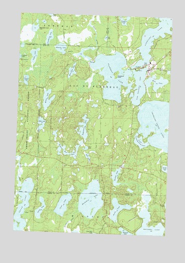
Lac du Flambeau, WI USGS Topographic Map
Click on map above to begin viewing in our Map Viewer.

This topographic map contains these locations and features:
Feature Name Type Latitude Longitude GNIS ID View Map
Bills LakeLakeN45.9368°W89.9803°1578786View Map
Booth LakeLakeN45.8893°W89.9148°1578840View Map
Broken Bow LakeLakeN45.9202°W89.9557°1578861View Map
Buckskin LakeLakeN45.8941°W89.9371°1578877View Map
Cedar LakeLakeN45.9761°W89.9878°1578970View Map
Clear LakeLakeN45.8910°W89.9600°1579016View Map
Cranberry LakeLakeN45.9866°W89.9758°1579051View Map
Crawling Stone LakeLakeN45.9382°W89.8838°1579062View Map
Favil LakeLakeN45.9618°W89.9941°1579229View Map
Flambeau LakeLakeN45.9646°W89.9237°1579254View Map
Flambeau Lake DamDamN45.9733°W89.9418°1792803View Map
Flambeau, Pokegama, Long I LakesReservoirN45.9733°W89.9417°1792804View Map
Fuller CreekStreamN45.8858°W89.9913°1579301View Map
Fuller LakeLakeN45.8882°W89.9785°1579302View Map
Gene LakeLakeN45.9188°W89.9409°1579318View Map
Haskell LakeLakeN45.9078°W89.9172°1579401View Map
Havener LakeLakeN45.8926°W89.8753°1579402View Map
Jerms LakeLakeN45.9133°W89.8751°1579530View Map
Lac du FlambeauPopulated PlaceN45.9697°W89.8921°1579611View Map
Lac du Flambeau Census Designated PlaceCensusN45.9696°W89.8995°2393075View Map
Lac Du Flambeau Elementary SchoolSchoolN45.9777°W89.8768°2713222View Map
Lac du Flambeau Fire and Ambulance Department Station 1BuildingN45.9686°W89.8939°2696825View Map
Lac du Flambeau Police DepartmentBuildingN45.9698°W89.8929°2759484View Map
Lac du Flambeau ReservationCivilN45.9849°W89.8772°1580845View Map
Little Crawling Stone LakeLakeN45.9283°W89.8981°1579675View Map
Little Ten LakeLakeN45.9347°W89.9156°2772424View Map
Long Interlaken LakeLakeN45.9600°W89.9010°1579734View Map
Lost LakeLakeN45.9872°W89.9294°1579768View Map
Minette LakeLakeN45.9806°W89.9660°1579884View Map
Minocqua Fire Department Station 2BuildingN45.8778°W89.9004°2696990View Map
Mitten LakeLakeN45.9510°W89.9758°1579893View Map
Moss LakeLakeN45.9625°W89.8870°1579927View Map
Patterson Hemlocks State Natural AreaParkN45.8953°W89.9692°2095667View Map
Pokegama LakeLakeN45.9923°W89.8877°1580178View Map
Poupart LakeLakeN45.9974°W89.9146°1580206View Map
Reservation Line LakeLakeN45.9915°W89.9881°1580243View Map
Ross Allen LakeLakeN45.9676°W89.9565°1580290View Map
Squaw LakeLakeN45.8845°W89.9946°1580521View Map
Strawberry IslandIslandN45.9663°W89.9196°1580542View Map
Tank LakeLakeN45.9237°W89.9428°1580579View Map
Tippecanoe LakeLakeN45.9353°W89.9455°1580619View Map
Town of Lac du FlambeauCivilN45.9718°W89.8804°1583497View Map
Wabasso Lake CampgroundLocaleN45.9733°W89.9985°1580968View Map

Note: Coordinates in the location and feature list above are referenced to NAD83 datum.


Copyright (C) 2008-2025 Ryan Niemi / Sunset Dynamics ... All Rights Reserved