TopoQuest Logo
Do you find TopoQuest useful?
Help keep TopoQuest running and adding new maps/features by donating!
Bitcoin:  19c7KJd3qBynnjoSw5npx9KScwjBe4ifkT
Litecoin:  LXs6TkuXGGXo1vDsWCkWVdjQX94eUKd6ui
Home View Maps Find Maps Find Places Resources & Links


Pike Lake, Wisconsin Topographic Map

USGS Map Title: Pike Lake, WI
USGS Map MRC: 45090H1
DRG (GeoTIFF) Download: o45090h1.tif


Neighboring USGS Topographic Map Quads:


  Turtle-Flambeau Flowage, WI  
46090A2
 

  Wilson Lake, WI  
46090A1
 

  Powell, WI  
46089A8
 

  Pike Lake NW, WI  
45090H2
 

  Pike Lake, WI  
45090H1
 

  Lac du Flambeau, WI  
45089H8
 

  Pike Lake SW, WI  
45090G2
 

  Pike Lake SE, WI  
45090G1
 

  Lac du Flambeau SW, WI  
45089G8


Map MRC Location:

N46°
W91°
N46°
W90°
H8 H7 H6 H5 H4 H3 H2 H1
G8 G7 G6 G5 G4 G3 G2 G1
F8 F7 F6 F5 F4 F3 F2 F1
E8 E7 E6 E5 E4 E3 E2 E1
D8 D7 D6 D5 D4 D3 D2 D1
C8 C7 C6 C5 C4 C3 C2 C1
B8 B7 B6 B5 B4 B3 B2 B1
A8 A7 A6 A5 A4 A3 A2 A1
N45°
W91°
N45°
W90°

Pike Lake, WI USGS 1:24K Topographic Map Preview:
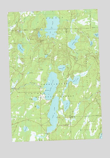
Pike Lake, WI USGS Topographic Map
Click on map above to begin viewing in our Map Viewer.

This topographic map contains these locations and features:
Feature Name Type Latitude Longitude GNIS ID View Map
Amik LakeLakeN45.9324°W90.0333°1578650View Map
Apeekwa LakeLakeN45.9684°W90.0349°1578664View Map
Bass Lake Preserve State Natural AreaParkN45.9992°W90.0231°2076409View Map
Big Pine LakeLakeN45.9843°W90.0640°1578777View Map
Caro Timber Picnic Ground (historical)LocaleN45.8919°W90.0557°1833494View Map
Cochran CreekStreamN45.9469°W90.1010°1579025View Map
Cochran LakeLakeN45.9647°W90.1086°1579026View Map
Deer LakeLakeN45.9078°W90.0877°1579104View Map
Duck LakeLakeN45.9896°W90.0347°1579155View Map
Emily CreekStreamN45.9744°W90.0271°1579211View Map
Emily LakeLakeN45.9669°W90.0105°1579212View Map
Emily Lake CampgroundLocaleN45.9641°W90.0146°1580922View Map
Ferry SpringsSpringN45.9730°W90.0954°1579237View Map
Fishtrap CampgroundLocaleN45.9263°W90.1185°1579245View Map
Foulds CreekStreamN45.8772°W90.0885°1579277View Map
Franks Seaplane BaseAirportN45.8833°W90.0002°1582038View Map
Jupa LakeLakeN45.9407°W90.0994°1579561View Map
Little Pine CreekStreamN45.9394°W90.0210°1579697View Map
McArthur LakeLakeN45.9155°W90.0913°1579830View Map
Memorial Grove Hemlocks State Natural AreaParkN45.8911°W90.0535°1989936View Map
Memorial Grove Picnic AreaParkN45.8891°W90.0521°1579858View Map
Miles LakeLakeN45.9771°W90.0822°1579870View Map
Oles LakeLakeN45.9436°W90.0829°1580055View Map
Pike LakeLakeN45.8998°W90.0667°1580141View Map
Pike Lake Fire DepartmentBuildingN45.9110°W90.0838°2696966View Map
Pine CreekStreamN45.9755°W90.0288°1580149View Map
Pond LakeLakeN45.8870°W90.1058°1580182View Map
Rice CreekStreamN45.9147°W90.0532°1580248View Map
Rice LakeLakeN45.9997°W90.0917°1580251View Map
Rice Lake CreekStreamN45.9863°W90.1052°1580253View Map
Round LakeLakeN45.9276°W90.0682°1580294View Map
Sentinal Point Lookout TowerTowerN45.9708°W90.0813°1581338View Map
Spring BranchStreamN45.9297°W90.1196°1580483View Map
Springstead CreekStreamN45.9261°W90.1213°1580506View Map
Squaw CreekStreamN45.9044°W90.0599°1580518View Map
Tackle LakeLakeN45.9806°W90.1071°1580572View Map
Thompson CreekStreamN45.9913°W90.1063°1580603View Map
Townline LakeLakeN45.9820°W90.0788°1580635View Map
Tucker CreekStreamN45.9333°W90.0438°1580658View Map
Tucker LakeLakeN45.9444°W90.0526°1580659View Map
Tucker Lake Hemlocks State Natural AreaParkN45.9444°W90.0602°1989937View Map
Turner LakeLakeN45.9086°W90.0482°1580660View Map
Twin LakesLakeN45.9562°W90.0738°1580675View Map
Twin Lakes CampgroundLocaleN45.9647°W90.0721°1580921View Map
Wabasso LakeLakeN45.9749°W90.0022°1580715View Map

Note: Coordinates in the location and feature list above are referenced to NAD83 datum.


Copyright (C) 2008-2025 Ryan Niemi / Sunset Dynamics ... All Rights Reserved