TopoQuest Logo
Do you find TopoQuest useful?
Help keep TopoQuest running and adding new maps/features by donating!
Bitcoin:  19c7KJd3qBynnjoSw5npx9KScwjBe4ifkT
Litecoin:  LXs6TkuXGGXo1vDsWCkWVdjQX94eUKd6ui
Home View Maps Find Maps Find Places Resources & Links


Lake Anna East, Virginia Topographic Map

USGS Map Title: Lake Anna East, VA
USGS Map MRC: 38077A6
DRG (GeoTIFF) Download: o38077a6.tif


Neighboring USGS Topographic Map Quads:


  Belmont, VA  
38077B7
 

  Brokenburg, VA  
38077B6
 

  Spotsylvania, VA  
38077B5
 

  Lake Anna West, VA  
38077A7
 

  Lake Anna East, VA  
38077A6
 

  Ladysmith, VA  
38077A5
 

  Buckner, VA  
37077H7
 

  Beaverdam, VA  
37077H6
 

  Hewlett, VA  
37077H5


Map MRC Location:

N39°
W78°
N39°
W77°
H8 H7 H6 H5 H4 H3 H2 H1
G8 G7 G6 G5 G4 G3 G2 G1
F8 F7 F6 F5 F4 F3 F2 F1
E8 E7 E6 E5 E4 E3 E2 E1
D8 D7 D6 D5 D4 D3 D2 D1
C8 C7 C6 C5 C4 C3 C2 C1
B8 B7 B6 B5 B4 B3 B2 B1
A8 A7 A6 A5 A4 A3 A2 A1
N38°
W78°
N38°
W77°

Lake Anna East, VA USGS 1:24K Topographic Map Preview:
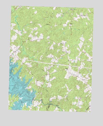
Lake Anna East, VA USGS Topographic Map
Click on map above to begin viewing in our Map Viewer.

This topographic map contains these locations and features:
Feature Name Type Latitude Longitude GNIS ID View Map
Arnolds CreekStreamN38.0121°W77.6858°1462556View Map
Bend (historical)Populated PlaceN38.0054°W77.7455°1494673View Map
Blount CoveBayN38.0379°W77.7275°1740264View Map
Bones IslandIslandN38.0004°W77.7317°1748934View Map
Brents LandingLocaleN38.0382°W77.7344°1740265View Map
Browns PointCapeN38.0093°W77.7347°1748936View Map
Burrus PointCapeN38.0199°W77.7347°1748937View Map
Burruss Mill (historical)LocaleN38.0346°W77.7492°1494676View Map
Chewnings CornerPopulated PlaceN38.0507°W77.6619°1477200View Map
Dannys HoleBayN38.0026°W77.7292°1748944View Map
Davenport BridgeBridgeN38.0062°W77.6767°1465625View Map
David CreekStreamN38.0040°W77.7342°1748945View Map
Duerson StoreLocaleN38.1049°W77.6594°1466028View Map
Dukes Creek MarinaLocaleN38.0596°W77.7494°1740275View Map
Fishermans CoveBayN38.0476°W77.7436°1740277View Map
GatewoodPopulated PlaceN38.0821°W77.6689°1495582View Map
Glebe RunStreamN38.1237°W77.6611°1474236View Map
Jerdone IslandIslandN38.0085°W77.7492°1748954View Map
LevyPopulated PlaceN38.0357°W77.7078°1477487View Map
LewistonPopulated PlaceN38.0687°W77.7422°1477488View Map
Little Rocky CreekStreamN38.0079°W77.6875°1469640View Map
Livingston Elementary SchoolSchoolN38.1244°W77.7379°1469710View Map
McGhee Bridge (historical)BridgeN38.0268°W77.7283°1740305View Map
Mount Olive ChurchChurchN38.0176°W77.6630°1470979View Map
Mount PleasantPopulated PlaceN38.1151°W77.6442°1471026View Map
New Hope Baptist ChurchChurchN38.0821°W77.7286°1471446View Map
North Anna DamDamN38.0132°W77.7130°1490868View Map
Northeast CreekStreamN38.0085°W77.6839°1471656View Map
PartlowPopulated PlaceN38.0387°W77.6389°1477611View Map
Partlow Post OfficePost OfficeN38.0387°W77.6396°1740309View Map
Penneys CrossroadPopulated PlaceN38.1032°W77.6919°1496072View Map
River Bend IslandIslandN38.0346°W77.7375°1740312View Map
Rock CreekStreamN38.0090°W77.7300°1473365View Map
Rockland CreekStreamN38.0390°W77.7411°1740313View Map
Saint Johns ChurchChurchN38.0718°W77.7461°1473780View Map
Smiths Mill (historical)LocaleN38.0124°W77.7011°1494725View Map
Smiths Mill BridgeBridgeN38.0126°W77.7014°1474784View Map
Spotsylvania County Fire and Rescue Station 3BuildingN38.0494°W77.6609°2075167View Map
Spotsylvania Volunteer Rescue Squad Station 3BuildingN38.0579°W77.6603°2331750View Map
Talley PointCapeN38.0499°W77.7447°1740325View Map
Tyler PointCapeN38.0193°W77.7397°1748974View Map
Valentine CoveBayN38.0212°W77.7122°1740329View Map
Walkups CoveBayN38.0090°W77.7383°1748975View Map
Wallers Baptist Church CemeteryCemeteryN38.0715°W77.6642°1740331View Map
Wallers ChurchChurchN38.0704°W77.6642°1476260View Map
Ways PointCapeN38.0104°W77.7394°1748976View Map

Note: Coordinates in the location and feature list above are referenced to NAD83 datum.


Copyright (C) 2008-2024 Ryan Niemi / Sunset Dynamics ... All Rights Reserved