TopoQuest Logo
Do you find TopoQuest useful?
Help keep TopoQuest running and adding new maps/features by donating!
Bitcoin:  19c7KJd3qBynnjoSw5npx9KScwjBe4ifkT
Litecoin:  LXs6TkuXGGXo1vDsWCkWVdjQX94eUKd6ui
Home View Maps Find Maps Find Places Resources & Links


Lake Jackson, Florida Topographic Map

USGS Map Title: Lake Jackson, FL
USGS Map MRC: 30084E3
DRG (GeoTIFF) Download: o30084e3.tif


Neighboring USGS Topographic Map Quads:


  Havana North, FL  
30084F4
 

  Calvary, GA  
30084F3
 

  Beachton, GA  
30084F2
 

  Havana South, FL  
30084E4
 

  Lake Jackson, FL  
30084E3
 

  Bradfordville, FL  
30084E2
 

  Midway, FL  
30084D4
 

  Tallahassee, FL  
30084D3
 

  Lafayette, FL  
30084D2


Map MRC Location:

N31°
W85°
N31°
W84°
H8 H7 H6 H5 H4 H3 H2 H1
G8 G7 G6 G5 G4 G3 G2 G1
F8 F7 F6 F5 F4 F3 F2 F1
E8 E7 E6 E5 E4 E3 E2 E1
D8 D7 D6 D5 D4 D3 D2 D1
C8 C7 C6 C5 C4 C3 C2 C1
B8 B7 B6 B5 B4 B3 B2 B1
A8 A7 A6 A5 A4 A3 A2 A1
N30°
W85°
N30°
W84°

Lake Jackson, FL USGS 1:24K Topographic Map Preview:
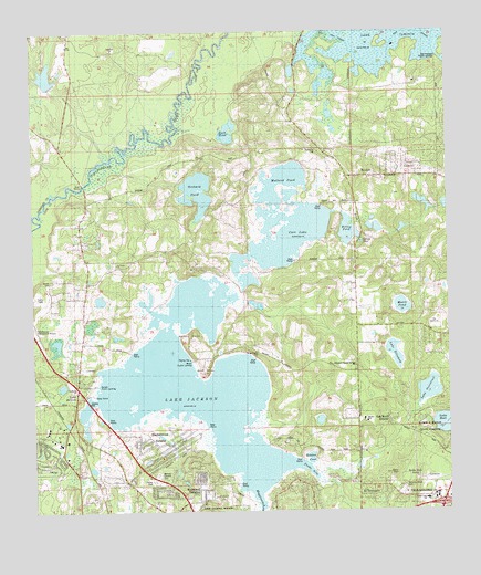
Lake Jackson, FL USGS Topographic Map
Click on map above to begin viewing in our Map Viewer.

This topographic map contains these locations and features:
Feature Name Type Latitude Longitude GNIS ID View Map
Advent Christian Church of TallahasseeChurchN30.5002°W84.3638°306816View Map
Alfred B Maclay Gardens State ParkParkN30.5191°W84.2505°293668View Map
Antioch Baptist ChurchChurchN30.5058°W84.3680°306812View Map
Bellwood EstatesPopulated PlaceN30.5041°W84.3282°278469View Map
Betholonia ChurchChurchN30.5941°W84.2868°278577View Map
BlockerPopulated PlaceN30.5874°W84.2735°278995View Map
Bridle Path AcresPopulated PlaceN30.5091°W84.2624°295152View Map
Brill PointCapeN30.5360°W84.3230°279401View Map
Buck PondLakeN30.5992°W84.3157°2004905View Map
Bull Headley Public LandingLocaleN30.6180°W84.2527°295162View Map
Carr LakeLakeN30.5723°W84.2984°280066View Map
Church of Christ-TimberlaneChurchN30.5044°W84.2638°300600View Map
El DestinadoPopulated PlaceN30.5055°W84.2774°295259View Map
Elinor Knapp-Phipps ParkParkN30.5319°W84.2930°2004907View Map
Elizabeth Popular Spring Primitive Baptist ChurchChurchN30.5377°W84.2777°300617View Map
Fords ArmBayN30.5112°W84.2929°282652View Map
Forestmeadows ParkParkN30.5344°W84.2824°2004906View Map
Friendship ChurchChurchN30.5496°W84.3596°282827View Map
Friendship Primitive Baptist ChurchChurchN30.5516°W84.3555°300615View Map
Gilchrist Elementary SchoolSchoolN30.5026°W84.2570°298423View Map
Harbinwood EstatesPopulated PlaceN30.5144°W84.3352°283705View Map
Holley PondLakeN30.5715°W84.2794°284159View Map
Killearn Gardens State ParkParkN30.5210°W84.2566°285100View Map
Lake ElizabethLakeN30.5410°W84.2662°282165View Map
Lake Iamonia Volunteer Fire Department and Emergency Medical ServicesBuildingN30.5869°W84.2533°2644620View Map
Lake JacksonPopulated PlaceN30.5324°W84.3616°294830View Map
Lake JacksonLakeN30.5315°W84.3249°284694View Map
Lake Jackson ChurchChurchN30.5605°W84.3485°301645View Map
Lake Jackson ChurchChurchN30.5613°W84.3582°285251View Map
Lake Jackson Free Will Baptist ChurchChurchN30.5349°W84.3624°300592View Map
Lake Jackson United Methodist ChurchChurchN30.5002°W84.3305°306780View Map
Lake Jackson Volunteer Fire Department and Emergency Medical ServicesBuildingN30.5284°W84.3685°2644133View Map
Lake OverstreetLakeN30.5312°W84.2563°288304View Map
Lewis CreekStreamN30.5919°W84.3538°2750134View Map
Little Lake JacksonLakeN30.5250°W84.3596°2747138View Map
Maclay SchoolSchoolN30.5238°W84.2756°301176View Map
Mallard PondLakeN30.5859°W84.2996°286326View Map
Meadowwood Memorial ParkCemeteryN30.5048°W84.2634°298549View Map
Millers Public LandingLocaleN30.5396°W84.3263°295456View Map
Moore CemeteryCemeteryN30.5602°W84.3696°287100View Map
Moore PondLakeN30.5534°W84.2637°287110View Map
Northwest Leon DivisionCivilN30.5067°W84.3463°1935876View Map
Oak Knoll EstatesPopulated PlaceN30.5238°W84.2663°287980View Map
Old Bainbridge County ParkParkN30.5380°W84.3582°2004904View Map
Orchard PondLakeN30.5835°W84.3251°288231View Map
Ox BottomBasinN30.5483°W84.2541°288319View Map
Parkhill ChurchChurchN30.5049°W84.3230°2004902View Map
Popular Spring ChurchChurchN30.5621°W84.2780°289218View Map
Rohden CoveBayN30.5141°W84.2920°289930View Map
Rollins PointCapeN30.5471°W84.3263°289935View Map
Saint Andrews Anglican ChurchChurchN30.5058°W84.2680°300596View Map
Saint Marks ChurchChurchN30.5333°W84.3618°290291View Map
Saint Mathews ChurchChurchN30.5416°W84.3077°290315View Map
Saint Paul African Methodist Episcopal ChurchChurchN30.5683°W84.3471°300616View Map
Saint Pauls ChurchChurchN30.5646°W84.3493°290362View Map
Scott Lookout TowerTowerN30.5858°W84.2691°301646View Map
Shepherd AcademySchoolN30.5029°W84.2604°301175View Map
Spring PondLakeN30.5702°W84.2760°291563View Map
Stoneler Road County ParkParkN30.5094°W84.3685°2004903View Map
Sunset Public LandingLocaleN30.5333°W84.3568°295656View Map
Tallahassee City Fire Department Station 10BuildingN30.5285°W84.3649°2644618View Map
Tallahassee City Fire Department Station 15BuildingN30.5869°W84.2533°2644055View Map
Tallahassee Memory Gardens CemeteryCemeteryN30.5099°W84.3380°286710View Map
Timber Lane SchoolSchoolN30.5030°W84.2566°2004908View Map
Timberlane Shops on the SquareLocaleN30.5041°W84.2541°295872View Map
WTNT-FM (Tallahassee)TowerN30.5788°W84.2635°310261View Map

Note: Coordinates in the location and feature list above are referenced to NAD83 datum.


Copyright (C) 2008-2025 Ryan Niemi / Sunset Dynamics ... All Rights Reserved