TopoQuest Logo
Do you find TopoQuest useful?
Help keep TopoQuest running and adding new maps/features by donating!
Bitcoin:  19c7KJd3qBynnjoSw5npx9KScwjBe4ifkT
Litecoin:  LXs6TkuXGGXo1vDsWCkWVdjQX94eUKd6ui
Home View Maps Find Maps Find Places Resources & Links


Calvary, Georgia Topographic Map

USGS Map Title: Calvary, GA
USGS Map MRC: 30084F3
DRG (GeoTIFF) Download: o30084f3.tif


Neighboring USGS Topographic Map Quads:


  Climax South, GA  
30084G4
 

  Reno, GA  
30084G3
 

  Cairo South, GA  
30084G2
 

  Havana North, FL  
30084F4
 

  Calvary, GA  
30084F3
 

  Beachton, GA  
30084F2
 

  Havana South, FL  
30084E4
 

  Lake Jackson, FL  
30084E3
 

  Bradfordville, FL  
30084E2


Map MRC Location:

N31°
W85°
N31°
W84°
H8 H7 H6 H5 H4 H3 H2 H1
G8 G7 G6 G5 G4 G3 G2 G1
F8 F7 F6 F5 F4 F3 F2 F1
E8 E7 E6 E5 E4 E3 E2 E1
D8 D7 D6 D5 D4 D3 D2 D1
C8 C7 C6 C5 C4 C3 C2 C1
B8 B7 B6 B5 B4 B3 B2 B1
A8 A7 A6 A5 A4 A3 A2 A1
N30°
W85°
N30°
W84°

Calvary, GA USGS 1:24K Topographic Map Preview:
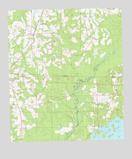
Calvary, GA USGS Topographic Map
Click on map above to begin viewing in our Map Viewer.

This topographic map contains these locations and features:
Feature Name Type Latitude Longitude GNIS ID View Map
Barber CemeteryCemeteryN30.6771°W84.3714°278096View Map
Beck Branch SchoolSchoolN30.7366°W84.3391°311015View Map
Bell CemeteryCemeteryN30.6532°W84.2577°278416View Map
Bell SchoolSchoolN30.6685°W84.2666°278432View Map
Bryants Mill CreekStreamN30.6833°W84.2977°311941View Map
Butler CemeteryCemeteryN30.6867°W84.3343°279736View Map
CalvaryPopulated PlaceN30.7269°W84.3496°354940View Map
Calvary Baptist ChurchChurchN30.7313°W84.3496°342455View Map
Calvary Census Designated PlaceCensusN30.7224°W84.3541°2587026View Map
Calvary United Methodist ChurchChurchN30.7302°W84.3493°342456View Map
Calvary-Reno DivisionCivilN30.7483°W84.3112°1936152View Map
China Hill ChurchChurchN30.6680°W84.2699°280393View Map
ConcordPopulated PlaceN30.6577°W84.3649°280701View Map
Concord Volunteer Fire DepartmentBuildingN30.6584°W84.3564°2644031View Map
Elkins CemeteryCemeteryN30.6994°W84.3477°342469View Map
Gainey CemeteryCemeteryN30.7496°W84.2610°314477View Map
Grady County Volunteer Fire Department Calvary StationBuildingN30.7272°W84.3485°2604189View Map
H H Swisher PondLakeN30.6516°W84.3441°298136View Map
Hiamonee (historical)Populated PlaceN30.6502°W84.2832°294537View Map
Higdon CemeteryCemeteryN30.7354°W84.3509°315379View Map
Lamonia CemeteryCemeteryN30.6607°W84.2660°285319View Map
MeridianPopulated PlaceN30.6385°W84.2818°286723View Map
Ocklockonee (historical)Populated PlaceN30.6669°W84.2999°294517View Map
Pedemont CemeteryCemeteryN30.7294°W84.3591°320332View Map
Piedmont Primitive Baptist Church (historical)ChurchN30.7288°W84.3596°342510View Map
Pine HillPopulated PlaceN30.7224°W84.2782°342514View Map
Pine Hill Assembly of God ChurchChurchN30.7216°W84.2824°342515View Map
Pine Hill CemeteryCemeteryN30.7219°W84.2824°342516View Map
Pine Hill ChurchChurchN30.7219°W84.2824°320591View Map
Rutten AirstripAirportN30.6829°W84.3708°309484View Map
Saint Calvary ChurchChurchN30.7321°W84.3382°342532View Map
Saint Johns ChurchChurchN30.6591°W84.3535°290229View Map
Saint Marys ChurchChurchN30.6671°W84.3143°290307View Map
Shaw CreekStreamN30.6533°W84.3005°294150View Map
Sugar Plum Lake DamDamN30.7019°W84.3749°342017View Map
Williams CemeteryCemeteryN30.7041°W84.3667°342554View Map
Williams CemeteryCemeteryN30.7277°W84.3041°342555View Map
Williams CemeteryCemeteryN30.7389°W84.3330°325324View Map

Note: Coordinates in the location and feature list above are referenced to NAD83 datum.


Copyright (C) 2008-2025 Ryan Niemi / Sunset Dynamics ... All Rights Reserved