TopoQuest Logo
Do you find TopoQuest useful?
Help keep TopoQuest running and adding new maps/features by donating!
Bitcoin:  19c7KJd3qBynnjoSw5npx9KScwjBe4ifkT
Litecoin:  LXs6TkuXGGXo1vDsWCkWVdjQX94eUKd6ui
Home View Maps Find Maps Find Places Resources & Links


Bradfordville, Florida Topographic Map

USGS Map Title: Bradfordville, FL
USGS Map MRC: 30084E2
DRG (GeoTIFF) Download: o30084e2.tif


Neighboring USGS Topographic Map Quads:


  Calvary, GA  
30084F3
 

  Beachton, GA  
30084F2
 

  Miccosukee NE, GA  
30084F1
 

  Lake Jackson, FL  
30084E3
 

  Bradfordville, FL  
30084E2
 

  Miccosukee, FL  
30084E1
 

  Tallahassee, FL  
30084D3
 

  Lafayette, FL  
30084D2
 

  Lloyd, FL  
30084D1


Map MRC Location:

N31°
W85°
N31°
W84°
H8 H7 H6 H5 H4 H3 H2 H1
G8 G7 G6 G5 G4 G3 G2 G1
F8 F7 F6 F5 F4 F3 F2 F1
E8 E7 E6 E5 E4 E3 E2 E1
D8 D7 D6 D5 D4 D3 D2 D1
C8 C7 C6 C5 C4 C3 C2 C1
B8 B7 B6 B5 B4 B3 B2 B1
A8 A7 A6 A5 A4 A3 A2 A1
N30°
W85°
N30°
W84°

Bradfordville, FL USGS 1:24K Topographic Map Preview:
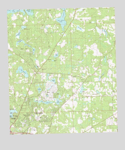
Bradfordville, FL USGS Topographic Map
Click on map above to begin viewing in our Map Viewer.

This topographic map contains these locations and features:
Feature Name Type Latitude Longitude GNIS ID View Map
Boat PondLakeN30.5780°W84.1944°279105View Map
Bradford PondLakeN30.5734°W84.1983°279315View Map
Bradford-Eppes CemeteryCemeteryN30.5644°W84.2110°279317View Map
BradfordvillePopulated PlaceN30.5613°W84.2177°294692View Map
Bradfordville Baptist ChurchChurchN30.5613°W84.2152°300591View Map
Celebration Baptist ChurchChurchN30.5224°W84.2055°300614View Map
CentervillePopulated PlaceN30.5571°W84.1763°295188View Map
Christian Covenant Community AcademySchoolN30.5558°W84.2096°301180View Map
Cromartie ArmBayN30.6209°W84.1846°281061View Map
Davis PondLakeN30.6105°W84.1504°281336View Map
Dawkins PondLakeN30.6230°W84.1644°281344View Map
Epiphany Lutheran SchoolSchoolN30.5266°W84.2368°301179View Map
Fellowship Presbyterian ChurchChurchN30.5183°W84.2055°300605View Map
Gilbert PondReservoirN30.5533°W84.1979°283071View Map
Huggle PondLakeN30.6001°W84.1367°284382View Map
Killearn Lakes Elementary SchoolSchoolN30.5842°W84.2262°298422View Map
Killearn Post OfficePost OfficeN30.5649°W84.2148°2759169View Map
Killearn United Methodist ChurchChurchN30.5155°W84.2027°300613View Map
Kinder Care Learning CenterSchoolN30.5063°W84.2271°301178View Map
Lake BelmontLakeN30.5379°W84.1818°2437385View Map
Lake HallLakeN30.5221°W84.2483°283627View Map
Lake KanturkLakeN30.5331°W84.1927°2437389View Map
Lake KillarneyLakeN30.5318°W84.2074°286058View Map
Lake KillkeeLakeN30.5468°W84.2019°2437390View Map
Lake KinsaleLakeN30.5330°W84.2193°2437391View Map
Lake McBrideLakeN30.5630°W84.2338°286564View Map
Lake Monkey BusinessLakeN30.6072°W84.2315°287064View Map
Lake SaratogaLakeN30.5411°W84.1929°2437397View Map
Lake SheelinLakeN30.5381°W84.2053°2437398View Map
Lake Tom JohnLakeN30.5443°W84.2146°292334View Map
Lester CemeteryCemeteryN30.5613°W84.2191°285469View Map
Little Roberts PondReservoirN30.5406°W84.1465°285788View Map
Lower Dianne LakeLakeN30.5926°W84.2356°281550View Map
Mitchell CemeteryCemeteryN30.6135°W84.2310°287003View Map
Mount Horbem ChurchChurchN30.5077°W84.2030°287225View Map
Mount Horeb Primitive Baptist ChurchChurchN30.5044°W84.2041°300607View Map
Mount Pleasant ChurchChurchN30.5244°W84.2368°287302View Map
Mount Pleasant Missionary Baptist ChurchChurchN30.5238°W84.2360°300611View Map
Mount Zion ChurchChurchN30.6244°W84.1696°287360View Map
New Bethlehem ChurchChurchN30.5727°W84.2280°287605View Map
New Bethlehem Primitive Baptist ChurchChurchN30.5752°W84.2277°300601View Map
Northeast Leon DivisionCivilN30.5975°W84.2305°1935869View Map
Petty Gulf LakeLakeN30.5891°W84.2272°288754View Map
Pickle PondLakeN30.6042°W84.1657°288780View Map
Pine Hill LakeLakeN30.5839°W84.2201°279127View Map
Pisgah ChurchChurchN30.5519°W84.1568°288996View Map
Roberts PondReservoirN30.5437°W84.1655°289788View Map
Rock Hill ChurchChurchN30.5408°W84.1293°289822View Map
Saint Philips CemeteryCemeteryN30.5532°W84.1660°290381View Map
Saint Philips ChurchChurchN30.5394°W84.1755°290382View Map
Seventh Day Adventist ChurchChurchN30.5460°W84.2249°300594View Map
Shady Grove ChurchChurchN30.5908°W84.1252°290904View Map
Spring Hill ChurchChurchN30.5719°W84.2268°291541View Map
Tallahassee Christian AssemblyChurchN30.5155°W84.2124°300587View Map
Tallahassee City Fire Department Station 11BuildingN30.5618°W84.1488°2644141View Map
Tallahassee City Fire Department Station 7BuildingN30.5124°W84.2229°2644053View Map
Testerina Primitive Baptist ChurchChurchN30.5321°W84.1846°300593View Map
Tree House AcademySchoolN30.5038°W84.2224°301177View Map
Upper Dianne LakeLakeN30.6003°W84.2375°2437419View Map
WMLO-FM (Havana)TowerN30.5866°W84.2363°309004View Map
Woodland Hall AcademySchoolN30.5176°W84.2016°301506View Map
WTWC-TV (Tallahassee)TowerN30.5866°W84.2363°309205View Map
WTXL-TV (Tallahassee)TowerN30.5744°W84.2024°309207View Map

Note: Coordinates in the location and feature list above are referenced to NAD83 datum.


Copyright (C) 2008-2024 Ryan Niemi / Sunset Dynamics ... All Rights Reserved