TopoQuest Logo
Do you find TopoQuest useful?
Help keep TopoQuest running and adding new maps/features by donating!
Bitcoin:  19c7KJd3qBynnjoSw5npx9KScwjBe4ifkT
Litecoin:  LXs6TkuXGGXo1vDsWCkWVdjQX94eUKd6ui
Home View Maps Find Maps Find Places Resources & Links


Lake Margrethe, Michigan Topographic Map

USGS Map Title: Lake Margrethe, MI
USGS Map MRC: 44084F7
DRG (GeoTIFF) Download: o44084f7.tif


Neighboring USGS Topographic Map Quads:


  Starvation Lake, MI  
44084G8
 

  Frederic, MI  
44084G7
 

  Big Bradford Lake, MI  
44084G6
 

  Black Creek, MI  
44084F8
 

  Lake Margrethe, MI  
44084F7
 

  Grayling, MI  
44084F6
 

  Fletcher, MI  
44084E8
 

  Cote Dame Marie, MI  
44084E7
 

  Pere Cheney, MI  
44084E6


Map MRC Location:

N45°
W85°
N45°
W84°
H8 H7 H6 H5 H4 H3 H2 H1
G8 G7 G6 G5 G4 G3 G2 G1
F8 F7 F6 F5 F4 F3 F2 F1
E8 E7 E6 E5 E4 E3 E2 E1
D8 D7 D6 D5 D4 D3 D2 D1
C8 C7 C6 C5 C4 C3 C2 C1
B8 B7 B6 B5 B4 B3 B2 B1
A8 A7 A6 A5 A4 A3 A2 A1
N44°
W85°
N44°
W84°

Lake Margrethe, MI USGS 1:24K Topographic Map Preview:
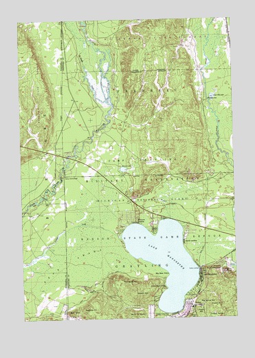
Lake Margrethe, MI USGS Topographic Map
Click on map above to begin viewing in our Map Viewer.

This topographic map contains these locations and features:
Feature Name Type Latitude Longitude GNIS ID View Map
Argonne HillSummitN44.6286°W84.8320°620212View Map
Bald KnobSummitN44.6275°W84.8481°620501View Map
Bear SwampSwampN44.6497°W84.8459°620876View Map
Big Bear PointCapeN44.6433°W84.7906°621291View Map
Camp ArrowheadLocaleN44.6845°W84.8514°622539View Map
Camp GraylingLocaleN44.6258°W84.7845°622579View Map
Collens LandingPopulated PlaceN44.6450°W84.7714°1617494View Map
Croshaw HillSummitN44.6300°W84.7636°624115View Map
Danish LandingPopulated PlaceN44.6575°W84.7800°624303View Map
Eagle PointCapeN44.6608°W84.7975°625093View Map
Goose CreekStreamN44.7161°W84.8245°626960View Map
Grayling Winter Recreation AreaParkN44.6445°W84.7553°627266View Map
Haan HillSummitN44.6270°W84.7711°627568View Map
Hanson State Game RefugeParkN44.6542°W84.7653°627745View Map
Howes LakeLakeN44.6875°W84.8146°628721View Map
Lake MargretheLakeN44.6495°W84.7916°631549View Map
Lake MargrethePopulated PlaceN44.6417°W84.7703°631550View Map
Lake Margrethe State Forest CampgroundLocaleN44.6572°W84.8167°2498789View Map
Little Bear PointCapeN44.6375°W84.7911°630557View Map
Manistee River Bridge State Forest CampgroundLocaleN44.6950°W84.8486°2498790View Map
McIntyre LandingPopulated PlaceN44.6650°W84.8084°631925View Map
Mont Saint MartinSummitN44.6261°W84.8092°632593View Map
Mount FranklinSummitN44.6453°W84.7670°626427View Map
RasmusPopulated PlaceN44.6300°W84.7750°1617811View Map
Red Arrow HillSummitN44.6325°W84.7639°635701View Map
Sand Hill LakeLakeN44.7176°W84.7623°637179View Map
Stewart HillSummitN44.6353°W84.8056°638833View Map
Thirty-Second Red Arrow Division Historical MarkerParkN44.6325°W84.7758°2498876View Map
Thompson HillSummitN44.6403°W84.8170°1614769View Map
United States Government Military CemeteryCemeteryN44.6439°W84.7556°2498859View Map
Upper Manistee River State Forest CampgroundLocaleN44.7481°W84.8381°2498791View Map
Wilson HillSummitN44.6270°W84.7761°1616574View Map

Note: Coordinates in the location and feature list above are referenced to NAD83 datum.


Copyright (C) 2008-2024 Ryan Niemi / Sunset Dynamics ... All Rights Reserved