TopoQuest Logo
Do you find TopoQuest useful?
Help keep TopoQuest running and adding new maps/features by donating!
Bitcoin:  19c7KJd3qBynnjoSw5npx9KScwjBe4ifkT
Litecoin:  LXs6TkuXGGXo1vDsWCkWVdjQX94eUKd6ui
Home View Maps Find Maps Find Places Resources & Links


Lake Quitman, Louisiana Topographic Map

USGS Map Title: Lake Quitman, LA
USGS Map MRC: 29090C6
DRG (GeoTIFF) Download: o29090c6.tif


Neighboring USGS Topographic Map Quads:


  Lake Theriot, LA  
29090D7
 

  Dulac, LA  
29090D6
 

  Montegut, LA  
29090D5
 

  Bayou Sauveur, LA  
29090C7
 

  Lake Quitman, LA  
29090C6
 

  Lake Tambour, LA  
29090C5
 

  Dog Lake, LA  
29090B7
 

  Cocodrie, LA  
29090B6
 

  Lake La Graisse, LA  
29090B5


Map MRC Location:

N30°
W91°
N30°
W90°
H8 H7 H6 H5 H4 H3 H2 H1
G8 G7 G6 G5 G4 G3 G2 G1
F8 F7 F6 F5 F4 F3 F2 F1
E8 E7 E6 E5 E4 E3 E2 E1
D8 D7 D6 D5 D4 D3 D2 D1
C8 C7 C6 C5 C4 C3 C2 C1
B8 B7 B6 B5 B4 B3 B2 B1
A8 A7 A6 A5 A4 A3 A2 A1
N29°
W91°
N29°
W90°

Lake Quitman, LA USGS 1:24K Topographic Map Preview:
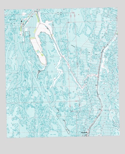
Lake Quitman, LA USGS Topographic Map
Click on map above to begin viewing in our Map Viewer.

This topographic map contains these locations and features:
Feature Name Type Latitude Longitude GNIS ID View Map
Alligator BayouBayN29.2821°W90.7456°532119View Map
Bayou BluffGutN29.3622°W90.7001°532461View Map
Bayou CantrelleGutN29.2616°W90.6337°532483View Map
Bayou DulacBayN29.3696°W90.6988°532579View Map
Bayou l'OurseBayN29.3013°W90.7464°1629904View Map
Bayou Petit CaillouBayN29.2655°W90.6511°553506View Map
Bayou PlatBayN29.3040°W90.7338°532727View Map
Bayou PlatStreamN29.3474°W90.7306°540703View Map
Clanton Chapel United Methodist ChurchChurchN29.3727°W90.7149°2601510View Map
Cure D'Ars ChapelChurchN29.3619°W90.7262°534305View Map
Deep SalineBayN29.2508°W90.6993°554210View Map
Deep Saline Gas FieldOilfieldN29.2511°W90.6618°1631787View Map
Dulac BridgeBridgeN29.3733°W90.7118°2601247View Map
Dulac Imco Services Dock HeliportAirportN29.3511°W90.7290°1632694View Map
Dulac SchoolSchoolN29.3719°W90.7151°534650View Map
Felix LakeBayN29.3250°W90.7405°554388View Map
Four Point BayouBayN29.2814°W90.7132°535062View Map
Grand Caillou Volunteer Fire DepartmentBuildingN29.3610°W90.7296°2332468View Map
Grand Pass ChalandChannelN29.3538°W90.6779°535344View Map
Grassy BayouGutN29.3199°W90.6804°535355View Map
Houma Terrebonne HeliportAirportN29.2505°W90.6623°1632662View Map
King BayouLakeN29.3638°W90.7292°536196View Map
L'eglise de DejuChurchN29.3722°W90.7204°536237View Map
Lake QuitmanBayN29.3452°W90.6712°555747View Map
Lapeyrouse CanalBayN29.3050°W90.6352°536335View Map
Lapeyrouse Oil and Gas FieldOilfieldN29.3244°W90.6473°536337View Map
Little Caillou Volunteer Fire Department Station 3BuildingN29.3351°W90.6416°2691734View Map
Little Pass ChalandChannelN29.3513°W90.6698°536587View Map
Picou CemeteryCemeteryN29.3366°W90.6404°551935View Map
Rabbit BayouBayN29.2675°W90.6609°538457View Map
Robinson CanalBayN29.3347°W90.6478°538650View Map
Sevin CanalCanalN29.2752°W90.6398°539264View Map
Sweetwater PondLakeN29.2827°W90.7009°556191View Map
Union Dulac HeliportAirportN29.3730°W90.7206°1632695View Map
Wax BayouBayN29.2669°W90.7271°540272View Map

Note: Coordinates in the location and feature list above are referenced to NAD83 datum.


Copyright (C) 2008-2024 Ryan Niemi / Sunset Dynamics ... All Rights Reserved