TopoQuest Logo
Do you find TopoQuest useful?
Help keep TopoQuest running and adding new maps/features by donating!
Bitcoin:  19c7KJd3qBynnjoSw5npx9KScwjBe4ifkT
Litecoin:  LXs6TkuXGGXo1vDsWCkWVdjQX94eUKd6ui
Home View Maps Find Maps Find Places Resources & Links


Lake Tuscaloosa North, Alabama Topographic Map

USGS Map Title: Lake Tuscaloosa North, AL
USGS Map MRC: 33087D5
DRG (GeoTIFF) Download: o33087d5.tif


Neighboring USGS Topographic Map Quads:


  New Lexington, AL  
33087E6
 

  Berry SE, AL  
33087E5
 

  Wiley, AL  
33087E4
 

  Gin Creek, AL  
33087D6
 

  Lake Tuscaloosa North, AL  
33087D5
 

  Windham Springs, AL  
33087D4
 

  Lake Lurleen, AL  
33087C6
 

  Lake Tuscaloosa South, AL  
33087C5
 

  Lake Nicol, AL  
33087C4


Map MRC Location:

N34°
W88°
N34°
W87°
H8 H7 H6 H5 H4 H3 H2 H1
G8 G7 G6 G5 G4 G3 G2 G1
F8 F7 F6 F5 F4 F3 F2 F1
E8 E7 E6 E5 E4 E3 E2 E1
D8 D7 D6 D5 D4 D3 D2 D1
C8 C7 C6 C5 C4 C3 C2 C1
B8 B7 B6 B5 B4 B3 B2 B1
A8 A7 A6 A5 A4 A3 A2 A1
N33°
W88°
N33°
W87°

Lake Tuscaloosa North, AL USGS 1:24K Topographic Map Preview:
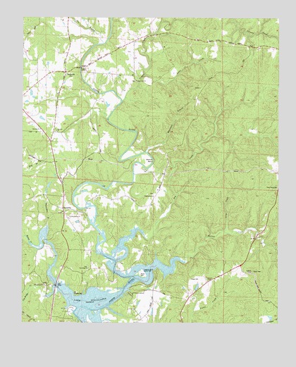
Lake Tuscaloosa North, AL USGS Topographic Map
Click on map above to begin viewing in our Map Viewer.

This topographic map contains these locations and features:
Feature Name Type Latitude Longitude GNIS ID View Map
Arbor Springs Baptist ChurchChurchN33.4187°W87.6017°113199View Map
Arbor Springs CemeteryCemeteryN33.4182°W87.6022°147818View Map
Bell City (historical)LocaleN33.3934°W87.6067°147845View Map
Binion CreekStreamN33.3904°W87.6086°158786View Map
Binion Creek Landing ParkParkN33.3918°W87.6070°147879View Map
Binion HeightsPopulated PlaceN33.3929°W87.6125°147880View Map
Cooper CemeteryCemeteryN33.3932°W87.5428°116576View Map
Cripple CreekStreamN33.4662°W87.5772°116871View Map
Cripple Creek CemeteryCemeteryN33.4746°W87.5706°148039View Map
Cripple Creek ChurchChurchN33.4746°W87.5708°116872View Map
Dry CreekStreamN33.4009°W87.5792°117575View Map
Ebenezer CemeteryCemeteryN33.4534°W87.6086°158725View Map
Ebenezer ChurchChurchN33.4534°W87.6081°117828View Map
Ebenezer School (historical)SchoolN33.4532°W87.6072°148089View Map
Gin BranchStreamN33.4898°W87.5867°118981View Map
Glenn (historical)LocaleN33.4248°W87.5614°148179View Map
Glenn School (historical)SchoolN33.4237°W87.5597°148180View Map
Hagler Mill EstatesPopulated PlaceN33.3793°W87.6000°148205View Map
Haglers Mill (historical)LocaleN33.3887°W87.6072°148204View Map
Harkey CemeteryCemeteryN33.3890°W87.6233°148208View Map
Holiday ShoresPopulated PlaceN33.3951°W87.5592°148239View Map
Holly Springs Baptist ChurchChurchN33.3907°W87.6142°120283View Map
Holly Springs CemeteryCemeteryN33.3907°W87.6147°148240View Map
Little CreekStreamN33.4768°W87.5667°121757View Map
Long CreekStreamN33.4132°W87.5264°122003View Map
Marcumville (historical)LocaleN33.4565°W87.6181°163294View Map
McGuire CemeteryCemeteryN33.4407°W87.6139°157831View Map
North River ShoresPopulated PlaceN33.3993°W87.5783°148385View Map
North RivieraPopulated PlaceN33.4001°W87.5672°148382View Map
Northside Gas FieldOilfieldN33.4571°W87.6236°154950View Map
Old Prewitte CemeteryCemeteryN33.3868°W87.5989°152788View Map
Oregonia School (historical)SchoolN33.4996°W87.5600°148419View Map
Patterson Chapel Methodist ChurchChurchN33.3929°W87.5342°155188View Map
Philadelphia (historical)LocaleN33.4271°W87.5600°148437View Map
Philadelphia Baptist ChurchChurchN33.4273°W87.5617°155194View Map
Philadelphia CemeteryCemeteryN33.4282°W87.5611°148438View Map
Piney Woods CemeteryCemeteryN33.4309°W87.5003°124883View Map
Pole Bridge CemeteryCemeteryN33.3979°W87.5931°158754View Map
Pole Bridge ChurchChurchN33.3979°W87.5928°125090View Map
Pole Bridge CreekStreamN33.3904°W87.6089°125091View Map
Pole Bridge School (historical)SchoolN33.3973°W87.5925°148458View Map
Prewitt CemeteryCemeteryN33.3823°W87.6033°148461View Map
SamanthaPopulated PlaceN33.4223°W87.6053°157010View Map
Samantha ChurchChurchN33.4546°W87.6170°126282View Map
Searcy FarmsPopulated PlaceN33.4043°W87.6111°148539View Map
Simpson-Cain CemeteryCemeteryN33.4046°W87.5669°148554View Map
Skelton BendBendN33.4418°W87.5656°126926View Map
Skelton Bend EstatesPopulated PlaceN33.4418°W87.5695°148558View Map
Thomas Mill BranchStreamN33.4151°W87.6128°127872View Map
Treasure Island County ParkParkN33.3959°W87.5667°128060View Map
Turkey CreekStreamN33.3932°W87.5697°128158View Map
Tuscaloosa Sailing ClubLocaleN33.3896°W87.5881°148667View Map
Wagon Wheel LakeReservoirN33.3899°W87.5396°131504View Map
Wagon Wheel Lake DamDamN33.3884°W87.5400°131503View Map
Walton CemeteryCemeteryN33.4865°W87.5722°158759View Map
Waltons Mill (historical)LocaleN33.4862°W87.5656°148711View Map
Whetstone BranchStreamN33.4457°W87.5658°128843View Map
Widow Jones SpringSpringN33.4848°W87.5728°148746View Map
Winters CemeteryCemeteryN33.4268°W87.6089°148756View Map

Note: Coordinates in the location and feature list above are referenced to NAD83 datum.


Copyright (C) 2008-2025 Ryan Niemi / Sunset Dynamics ... All Rights Reserved