TopoQuest Logo
Do you find TopoQuest useful?
Help keep TopoQuest running and adding new maps/features by donating!
Bitcoin:  19c7KJd3qBynnjoSw5npx9KScwjBe4ifkT
Litecoin:  LXs6TkuXGGXo1vDsWCkWVdjQX94eUKd6ui
Home View Maps Find Maps Find Places Resources & Links


Berry SE, Alabama Topographic Map

USGS Map Title: Berry SE, AL
USGS Map MRC: 33087E5
DRG (GeoTIFF) Download: o33087e5.tif


Neighboring USGS Topographic Map Quads:


  Bankston, AL  
33087F6
 

  Berry, AL  
33087F5
 

  Oakman, AL  
33087F4
 

  New Lexington, AL  
33087E6
 

  Berry SE, AL  
33087E5
 

  Wiley, AL  
33087E4
 

  Gin Creek, AL  
33087D6
 

  Lake Tuscaloosa North, AL  
33087D5
 

  Windham Springs, AL  
33087D4


Map MRC Location:

N34°
W88°
N34°
W87°
H8 H7 H6 H5 H4 H3 H2 H1
G8 G7 G6 G5 G4 G3 G2 G1
F8 F7 F6 F5 F4 F3 F2 F1
E8 E7 E6 E5 E4 E3 E2 E1
D8 D7 D6 D5 D4 D3 D2 D1
C8 C7 C6 C5 C4 C3 C2 C1
B8 B7 B6 B5 B4 B3 B2 B1
A8 A7 A6 A5 A4 A3 A2 A1
N33°
W88°
N33°
W87°

Berry SE, AL USGS 1:24K Topographic Map Preview:
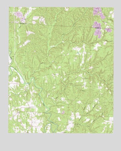
Berry SE, AL USGS Topographic Map
Click on map above to begin viewing in our Map Viewer.

This topographic map contains these locations and features:
Feature Name Type Latitude Longitude GNIS ID View Map
Appling (historical)LocaleN33.6004°W87.6022°147816View Map
Bear CreekStreamN33.5246°W87.5764°113667View Map
Bethlehem ChurchChurchN33.5584°W87.5714°147864View Map
Bethlehem Church SpringSpringN33.5559°W87.5695°147865View Map
Boone CreekStreamN33.5490°W87.6000°114738View Map
Brand BranchStreamN33.5173°W87.5364°114828View Map
Cedar CreekStreamN33.5790°W87.6222°115755View Map
Dobbs Temple (historical)ChurchN33.5579°W87.5920°148057View Map
Dry BranchStreamN33.5468°W87.5558°117502View Map
Evanstown (historical)LocaleN33.5046°W87.5347°148109View Map
Fairview CemeteryCemeteryN33.5768°W87.6050°118135View Map
Fairview Church (historical)ChurchN33.5759°W87.6050°148115View Map
Fairview School (historical)SchoolN33.5757°W87.6050°148116View Map
Finley BranchStreamN33.5068°W87.5289°118284View Map
GorgasPopulated PlaceN33.5201°W87.6139°148189View Map
Gorgas Elementary School (historical)SchoolN33.5207°W87.6125°119181View Map
Gum Springs ChurchChurchN33.5457°W87.5200°148202View Map
Gum Springs School (historical)SchoolN33.5457°W87.5208°148203View Map
Johnson BranchStreamN33.5084°W87.5400°120927View Map
Johnson CemeteryCemeteryN33.5757°W87.6208°120939View Map
Liberty Hill CemeteryCemeteryN33.5548°W87.5342°148330View Map
Liberty Hill Primitive Baptist ChurchChurchN33.5548°W87.5347°152056View Map
Little Tyro CreekStreamN33.5834°W87.5764°121898View Map
Meg MineMineN33.5043°W87.5444°157839View Map
North River Number 1 MineMineN33.6140°W87.6083°137755View Map
Oregonia Baptist ChurchChurchN33.5009°W87.5589°152819View Map
Oregonia CemeteryCemeteryN33.5007°W87.5597°148418View Map
Poplar HollowValleyN33.5929°W87.5133°125151View Map
Ridge School (historical)SchoolN33.5193°W87.6125°148482View Map
Scraptown (historical)LocaleN33.5701°W87.5611°148538View Map
Stanley (historical)LocaleN33.5518°W87.5550°148598View Map
Stanley CemeteryCemeteryN33.5507°W87.5544°127308View Map
Sterling (historical)LocaleN33.5579°W87.5733°148600View Map
Sterling CemeteryCemeteryN33.5582°W87.5711°158933View Map
Sulphur Springs CemeteryCemeteryN33.5251°W87.5983°148606View Map
Sulphur Springs Freewill Baptist ChurchChurchN33.5251°W87.5989°158935View Map
Tyro CreekStreamN33.5546°W87.5972°128241View Map
Tyro Creek HillSummitN33.5568°W87.5853°148675View Map
Union Grove Baptist ChurchChurchN33.6104°W87.5117°153780View Map
Union Grove CemeteryCemeteryN33.6101°W87.5125°143014View Map
Union Grove MineMineN33.6209°W87.5222°137780View Map
Utley CemeteryCemeteryN33.5098°W87.5503°128380View Map
Wallace BranchStreamN33.5904°W87.5611°128533View Map
Willingham CemeteryCemeteryN33.5646°W87.6061°129043View Map
Wilsons School (historical)SchoolN33.5734°W87.6122°137783View Map
Wittson BridgeBridgeN33.5496°W87.6020°154012View Map

Note: Coordinates in the location and feature list above are referenced to NAD83 datum.


Copyright (C) 2008-2025 Ryan Niemi / Sunset Dynamics ... All Rights Reserved