TopoQuest Logo
Do you find TopoQuest useful?
Help keep TopoQuest running and adding new maps/features by donating!
Bitcoin:  19c7KJd3qBynnjoSw5npx9KScwjBe4ifkT
Litecoin:  LXs6TkuXGGXo1vDsWCkWVdjQX94eUKd6ui
Home View Maps Find Maps Find Places Resources & Links


New Lexington, Alabama Topographic Map

USGS Map Title: New Lexington, AL
USGS Map MRC: 33087E6
DRG (GeoTIFF) Download: o33087e6.tif


Neighboring USGS Topographic Map Quads:


  Fayette, AL  
33087F7
 

  Bankston, AL  
33087F6
 

  Berry, AL  
33087F5
 

  Newtonville, AL  
33087E7
 

  New Lexington, AL  
33087E6
 

  Berry SE, AL  
33087E5
 

  Brownville, AL  
33087D7
 

  Gin Creek, AL  
33087D6
 

  Lake Tuscaloosa North, AL  
33087D5


Map MRC Location:

N34°
W88°
N34°
W87°
H8 H7 H6 H5 H4 H3 H2 H1
G8 G7 G6 G5 G4 G3 G2 G1
F8 F7 F6 F5 F4 F3 F2 F1
E8 E7 E6 E5 E4 E3 E2 E1
D8 D7 D6 D5 D4 D3 D2 D1
C8 C7 C6 C5 C4 C3 C2 C1
B8 B7 B6 B5 B4 B3 B2 B1
A8 A7 A6 A5 A4 A3 A2 A1
N33°
W88°
N33°
W87°

New Lexington, AL USGS 1:24K Topographic Map Preview:
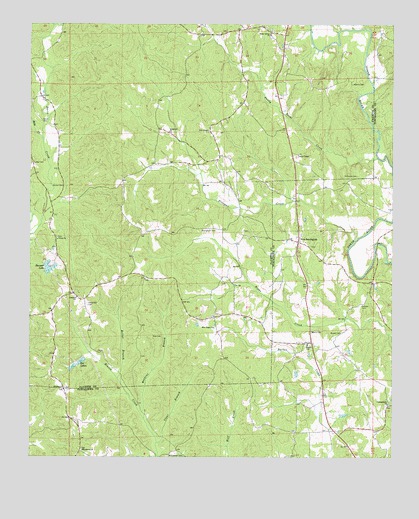
New Lexington, AL USGS Topographic Map
Click on map above to begin viewing in our Map Viewer.

This topographic map contains these locations and features:
Feature Name Type Latitude Longitude GNIS ID View Map
Adams CemeteryCemeteryN33.6079°W87.6389°112919View Map
Barnett LakeReservoirN33.5548°W87.7438°113504View Map
Barnett Lake DamDamN33.5534°W87.7467°131605View Map
Belle CreekStreamN33.5918°W87.7458°113873View Map
Bolter BranchStreamN33.5229°W87.7197°114701View Map
Boone CemeteryCemeteryN33.5362°W87.6531°114736View Map
Bryant CemeteryCemeteryN33.5362°W87.6425°115083View Map
Camp Ground CemeteryCemeteryN33.5148°W87.6272°159023View Map
Campground ChurchChurchN33.5154°W87.6264°115510View Map
Center Point School (historical)SchoolN33.5643°W87.7411°137706View Map
Clear BranchStreamN33.5040°W87.7064°116215View Map
ConcordPopulated PlaceN33.5457°W87.7303°137709View Map
Concord Baptist ChurchChurchN33.5462°W87.7342°116496View Map
Concord CemeteryCemeteryN33.5468°W87.7345°143003View Map
Concord School (historical)SchoolN33.5459°W87.7336°137710View Map
Davis ChapelChurchN33.5873°W87.6575°158810View Map
Davis Creek Post Office (historical)Post OfficeN33.6043°W87.7458°166074View Map
Dawson CemeteryCemeteryN33.5443°W87.6353°117148View Map
El Bethel CemeteryCemeteryN33.5196°W87.7375°159024View Map
El Bethel United Methodist ChurchChurchN33.5201°W87.7378°157943View Map
Etteca School (historical)SchoolN33.5326°W87.6545°118048View Map
Freeman CreekStreamN33.5626°W87.6381°118625View Map
Freewill Church (historical)ChurchN33.5834°W87.6578°137728View Map
Hocutts Mill (historical)LocaleN33.5357°W87.6264°148236View Map
Hopewell CemeteryCemeteryN33.5937°W87.7017°158487View Map
Hopewell ChurchChurchN33.5943°W87.7022°120376View Map
Lexington Gas FieldOilfieldN33.5368°W87.6492°154914View Map
Macedonia Baptist ChurchChurchN33.5021°W87.7320°152185View Map
Macedonia CemeteryCemeteryN33.5023°W87.7320°148352View Map
Melton CemeteryCemeteryN33.5782°W87.7386°158868View Map
New ChapelChurchN33.5946°W87.6886°158883View Map
New Chapel CemeteryCemeteryN33.5943°W87.6881°158486View Map
New Chapel School (historical)SchoolN33.5948°W87.6878°137751View Map
New HopePopulated PlaceN33.5396°W87.6864°137752View Map
New Hope ChurchChurchN33.5376°W87.6867°123831View Map
New LexingtonPopulated PlaceN33.5623°W87.6575°152656View Map
Obye School (historical)SchoolN33.5407°W87.6811°137758View Map
Patterson CemeteryCemeteryN33.5443°W87.7303°124489View Map
Poe LakesReservoirN33.5277°W87.7322°125075View Map
Reed Springs School (historical)SchoolN33.5071°W87.6528°148475View Map
Reuben (historical)LocaleN33.5023°W87.6995°166200View Map
Reuben Post Office (historical)Post OfficeN33.5023°W87.6995°169303View Map
Rice CemeteryCemeteryN33.5354°W87.7078°125591View Map
Richards Mill (historical)LocaleN33.6104°W87.7431°137767View Map
Rock CreekStreamN33.5740°W87.6595°148497View Map
Salem Baptist ChurchChurchN33.5623°W87.6550°148524View Map
Salem CemeteryCemeteryN33.5612°W87.6533°148523View Map
Salem CemeteryCemeteryN33.5625°W87.6553°2674959View Map
Sandy Point CreekStreamN33.5865°W87.6303°126384View Map
Shady Grove Baptist ChurchChurchN33.6221°W87.6675°158921View Map
Shady Grove CemeteryCemeteryN33.6215°W87.6672°158485View Map
Simmons CemeteryCemeteryN33.5815°W87.6372°126867View Map
South CemeteryCemeteryN33.5973°W87.7461°158926View Map
Tucker CemeteryCemeteryN33.5851°W87.7495°128109View Map
Unity ChurchChurchN33.5632°W87.7408°153809View Map
Unity Grove CemeteryCemeteryN33.5634°W87.7403°158488View Map
Vick and Kelley CemeteryCemeteryN33.6218°W87.6906°158324View Map
Watkins BranchStreamN33.5112°W87.7108°128630View Map
Williamson CemeteryCemeteryN33.5004°W87.7022°154000View Map
Willingham CemeteryCemeteryN33.5654°W87.6861°129044View Map

Note: Coordinates in the location and feature list above are referenced to NAD83 datum.


Copyright (C) 2008-2025 Ryan Niemi / Sunset Dynamics ... All Rights Reserved