TopoQuest Logo
Do you find TopoQuest useful?
Help keep TopoQuest running and adding new maps/features by donating!
Bitcoin:  19c7KJd3qBynnjoSw5npx9KScwjBe4ifkT
Litecoin:  LXs6TkuXGGXo1vDsWCkWVdjQX94eUKd6ui
Home View Maps Find Maps Find Places Resources & Links


Lake Waccamaw West, North Carolina Topographic Map

USGS Map Title: Lake Waccamaw West, NC
USGS Map MRC: 34078C5
DRG (GeoTIFF) Download: o34078c5.tif


Neighboring USGS Topographic Map Quads:


  Clarkton, NC  
34078D6
 

  Emerson, NC  
34078D5
 

  Council, NC  
34078D4
 

  Whiteville, NC  
34078C6
 

  Lake Waccamaw West, NC  
34078C5
 

  Lake Waccamaw East, NC  
34078C4
 

  Nakina, NC  
34078B6
 

  Old Dock, NC  
34078B5
 

  Juniper Creek, NC  
34078B4


Map MRC Location:

N35°
W79°
N35°
W78°
H8 H7 H6 H5 H4 H3 H2 H1
G8 G7 G6 G5 G4 G3 G2 G1
F8 F7 F6 F5 F4 F3 F2 F1
E8 E7 E6 E5 E4 E3 E2 E1
D8 D7 D6 D5 D4 D3 D2 D1
C8 C7 C6 C5 C4 C3 C2 C1
B8 B7 B6 B5 B4 B3 B2 B1
A8 A7 A6 A5 A4 A3 A2 A1
N34°
W79°
N34°
W78°

Lake Waccamaw West, NC USGS 1:24K Topographic Map Preview:
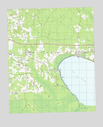
Lake Waccamaw West, NC USGS Topographic Map
Click on map above to begin viewing in our Map Viewer.

This topographic map contains these locations and features:
Feature Name Type Latitude Longitude GNIS ID View Map
Alligator BranchStreamN34.2799°W78.5622°980127View Map
ArtesiaPopulated PlaceN34.3224°W78.5750°980295View Map
Artesia SchoolSchoolN34.3110°W78.5789°980296View Map
Batten CemeteryCemeteryN34.3746°W78.5736°1026258View Map
Betsy Burgh IslandCapeN34.2852°W78.5514°1025140View Map
Big ForkStreamN34.2921°W78.6200°981393View Map
Big IslandIslandN34.2638°W78.5492°981406View Map
Boggy BranchStreamN34.3410°W78.5803°1025175View Map
Bogue SwampStreamN34.2643°W78.5578°1025176View Map
Boys Home Junior High SchoolSchoolN34.3213°W78.5308°1006507View Map
Country Side Mobile Home ParkPopulated PlaceN34.3550°W78.6219°2505442View Map
Cove CanalCanalN34.3010°W78.5531°1026257View Map
Cove SwampSwampN34.3135°W78.5508°983623View Map
Cowpen BranchStreamN34.3188°W78.5892°983656View Map
Cypress PondSwampN34.3399°W78.5295°983901View Map
Dupree LandingLocaleN34.2927°W78.5492°1020058View Map
First Baptist Church of Lake WaccamawChurchN34.3233°W78.5179°2611313View Map
HallsboroPopulated PlaceN34.3224°W78.5989°986326View Map
Hallsboro Census Designated PlaceCensusN34.3189°W78.5934°2628631View Map
Hallsboro Elementary SchoolSchoolN34.3110°W78.5789°1006504View Map
Hallsboro High SchoolSchoolN34.3207°W78.5931°1006505View Map
Hallsboro Post OfficePost OfficeN34.3225°W78.6003°2505370View Map
Hallsboro Volunteer Fire Department Station 16BuildingN34.3217°W78.5995°2638508View Map
Honey Hill ChurchChurchN34.2746°W78.6142°987012View Map
Jockey BranchStreamN34.3035°W78.5908°987618View Map
Jonesboro CrossingPopulated PlaceN34.3218°W78.6236°1006262View Map
Kentuck IslandFlatN34.2599°W78.5911°1025453View Map
Lake WaccamawPopulated PlaceN34.3191°W78.5000°988088View Map
Lake WaccamawLakeN34.2867°W78.5097°996653View Map
Lake Waccamaw Fire Department and Rescue SquadBuildingN34.3197°W78.5224°2639005View Map
Lake Waccamaw Fire Department and Rescue Squad Station 27BuildingN34.2933°W78.5566°2639071View Map
Lake Waccamaw Police DepartmentBuildingN34.3193°W78.5228°2130999View Map
Lake Waccamaw Post OfficePost OfficeN34.3228°W78.5220°2505380View Map
Lake Waccamaw Wastewater Treatment PlantLocaleN34.2835°W78.5567°2506008View Map
Lamberts BaySwampN34.3543°W78.5533°988115View Map
Long IslandCapeN34.2732°W78.5697°1025500View Map
Mount Hebron ChurchChurchN34.3141°W78.6061°1000976View Map
Mount Hebron Memorial ParkCemeteryN34.3129°W78.5992°1000975View Map
Mount Olive ChurchChurchN34.3643°W78.6131°990462View Map
New Light ChurchChurchN34.3296°W78.5997°991064View Map
Palmetto BranchStreamN34.2949°W78.5842°991802View Map
Pierce CemeteryCemeteryN34.3060°W78.6078°992169View Map
Pierce CemeteryCemeteryN34.2824°W78.5781°1026256View Map
RedbugPopulated PlaceN34.3085°W78.6120°993137View Map
Saint Paul ChurchChurchN34.2893°W78.6186°994070View Map
Sibbitt CemeteryCemeteryN34.2754°W78.6170°994786View Map
Slab RunStreamN34.2643°W78.5870°994897View Map
Slap SwampSwampN34.3599°W78.5000°1025706View Map
Spring BranchStreamN34.3504°W78.5725°995321View Map
The CoveBayN34.3021°W78.5489°995967View Map
Town of Lake WaccamawCivilN34.3140°W78.5116°2405979View Map
Township of BogueCivilN34.2973°W78.5992°1026571View Map
Township of WaccamawCivilN34.3398°W78.5046°1026581View Map
WananishPopulated PlaceN34.3221°W78.5003°996764View Map
Weavers LandingLocaleN34.3168°W78.5242°1023143View Map
White Oak BranchStreamN34.3421°W78.5764°997156View Map

Note: Coordinates in the location and feature list above are referenced to NAD83 datum.


Copyright (C) 2008-2024 Ryan Niemi / Sunset Dynamics ... All Rights Reserved