TopoQuest Logo
Do you find TopoQuest useful?
Help keep TopoQuest running and adding new maps/features by donating!
Bitcoin:  19c7KJd3qBynnjoSw5npx9KScwjBe4ifkT
Litecoin:  LXs6TkuXGGXo1vDsWCkWVdjQX94eUKd6ui
Home View Maps Find Maps Find Places Resources & Links


Lakefield, Michigan Topographic Map

USGS Map Title: Lakefield, MI
USGS Map MRC: 43084C3
DRG (GeoTIFF) Download: o43084c3.tif


Neighboring USGS Topographic Map Quads:


  Breckenridge, MI  
43084D4
 

  Merrill, MI  
43084D3
 

  Hemlock, MI  
43084D2
 

  Rathbone, MI  
43084C4
 

  Lakefield, MI  
43084C3
 

  Saint Charles, MI  
43084C2
 

  Ashley, MI  
43084B4
 

  Chapin, MI  
43084B3
 

  Chesaning West, MI  
43084B2


Map MRC Location:

N44°
W85°
N44°
W84°
H8 H7 H6 H5 H4 H3 H2 H1
G8 G7 G6 G5 G4 G3 G2 G1
F8 F7 F6 F5 F4 F3 F2 F1
E8 E7 E6 E5 E4 E3 E2 E1
D8 D7 D6 D5 D4 D3 D2 D1
C8 C7 C6 C5 C4 C3 C2 C1
B8 B7 B6 B5 B4 B3 B2 B1
A8 A7 A6 A5 A4 A3 A2 A1
N43°
W85°
N43°
W84°

Lakefield, MI USGS 1:24K Topographic Map Preview:
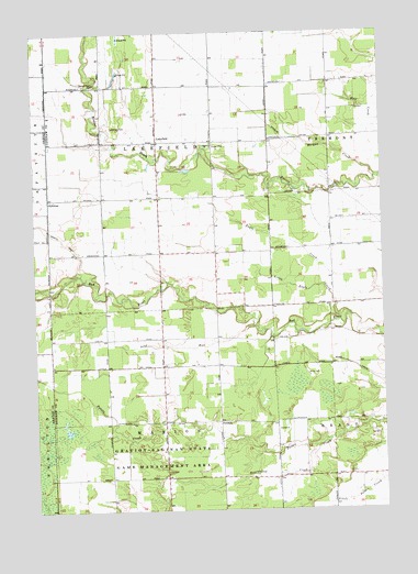
Lakefield, MI USGS Topographic Map
Click on map above to begin viewing in our Map Viewer.

This topographic map contains these locations and features:
Feature Name Type Latitude Longitude GNIS ID View Map
Bearwallow CreekStreamN43.2664°W84.2755°620888View Map
FordneyPopulated PlaceN43.2731°W84.3094°1617565View Map
Fordney Post Office (historical)Post OfficeN43.2731°W84.3094°2558495View Map
GallowayPopulated PlaceN43.3317°W84.3694°1617575View Map
Galloway Post Office (historical)Post OfficeN43.3319°W84.3703°2562133View Map
LakefieldPopulated PlaceN43.3464°W84.3305°1617668View Map
Lakefield CemeteryCemeteryN43.3506°W84.3492°630009View Map
Lakefield Post Office (historical)Post OfficeN43.3464°W84.3306°2558488View Map
Little Eagle CreekStreamN43.3011°W84.2628°630616View Map
Marion Township Fire DepartmentBuildingN43.2606°W84.3283°2635982View Map
Morgan CreekStreamN43.3370°W84.2522°632688View Map
Sacred Heart CemeteryCemeteryN43.3614°W84.3522°636460View Map
Soap RunStreamN43.2981°W84.2961°638226View Map
Township of LakefieldCivilN43.3463°W84.3300°1626583View Map
Township of MarionCivilN43.2587°W84.3288°1626691View Map
Twin Bridges Golf CourseLocaleN43.3733°W84.3542°2558788View Map

Note: Coordinates in the location and feature list above are referenced to NAD83 datum.


Copyright (C) 2008-2025 Ryan Niemi / Sunset Dynamics ... All Rights Reserved