TopoQuest Logo
Do you find TopoQuest useful?
Help keep TopoQuest running and adding new maps/features by donating!
Bitcoin:  19c7KJd3qBynnjoSw5npx9KScwjBe4ifkT
Litecoin:  LXs6TkuXGGXo1vDsWCkWVdjQX94eUKd6ui
Home View Maps Find Maps Find Places Resources & Links


Lassater, Texas Topographic Map

USGS Map Title: Lassater, TX
USGS Map MRC: 32094G5
DRG (GeoTIFF) Download: o32094g5.tif


Neighboring USGS Topographic Map Quads:


  Lone Star, TX  
32094H6
 

  Avinger, TX  
32094H5
 

  Cunningham Creek, TX  
32094H4
 

  Ore City, TX  
32094G6
 

  Lassater, TX  
32094G5
 

  Kellyville, TX  
32094G4
 

  Ashland, TX  
32094F6
 

  Harleton, TX  
32094F5
 

  Marshall NW, TX  
32094F4


Map MRC Location:

N33°
W95°
N33°
W94°
H8 H7 H6 H5 H4 H3 H2 H1
G8 G7 G6 G5 G4 G3 G2 G1
F8 F7 F6 F5 F4 F3 F2 F1
E8 E7 E6 E5 E4 E3 E2 E1
D8 D7 D6 D5 D4 D3 D2 D1
C8 C7 C6 C5 C4 C3 C2 C1
B8 B7 B6 B5 B4 B3 B2 B1
A8 A7 A6 A5 A4 A3 A2 A1
N32°
W95°
N32°
W94°

Lassater, TX USGS 1:24K Topographic Map Preview:
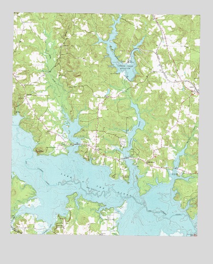
Lassater, TX USGS Topographic Map
Click on map above to begin viewing in our Map Viewer.

This topographic map contains these locations and features:
Feature Name Type Latitude Longitude GNIS ID View Map
Adams ChapelChurchN32.8282°W94.5613°1329208View Map
Alley CreekStreamN32.7962°W94.5852°1329403View Map
Alley Creek ParkParkN32.8010°W94.5974°2028881View Map
Alley Creek Recreation AreaParkN32.7996°W94.5921°1329404View Map
Arms CreekStreamN32.7607°W94.6216°1329684View Map
Big Cypress CreekStreamN32.7512°W94.5019°1372545View Map
Copeland CreekStreamN32.7571°W94.5980°1333315View Map
Copeland Creek Recreation AreaParkN32.7537°W94.5924°1333316View Map
Felix A Smith LakeReservoirN32.8308°W94.5612°1861905View Map
Felix A Smith Lake DamDamN32.8335°W94.5602°1861904View Map
Hurricane CreekStreamN32.7779°W94.5188°1338322View Map
Hurricane Creek Recreation AreaParkN32.7851°W94.5130°1338323View Map
Jackson Volunteer Fire DepartmentBuildingN32.7506°W94.5610°2655715View Map
Johnson CreekStreamN32.7787°W94.5435°1338795View Map
Johnson Creek DamDamN32.8401°W94.5485°1861902View Map
Johnson Creek Recreation AreaParkN32.7829°W94.5508°1338796View Map
Johnson Creek ReservoirReservoirN32.8428°W94.5548°1338797View Map
Lake Ferrell Oil FieldAreaN32.8035°W94.5710°1339499View Map
Lake O' the PinesReservoirN32.8007°W94.6097°1375468View Map
Lake O' the Pines DivisionCivilN32.7979°W94.5147°1938965View Map
LassaterPopulated PlaceN32.8340°W94.5027°1378565View Map
Lassater Gas FieldOilfieldN32.8579°W94.5855°1339695View Map
Locks MountainSummitN32.7968°W94.6077°1340315View Map
Lone Oak ChurchChurchN32.7507°W94.5644°1340385View Map
Mc Kenzie FieldAirportN32.8128°W94.6153°1386193View Map
Mims ChapelChurchN32.8285°W94.6155°1341702View Map
Mims Volunteer Fire Department and Ambulance ServiceBuildingN32.8199°W94.6105°2655397View Map
OrrsPopulated PlaceN32.8426°W94.5246°1378809View Map
Pyland CemeteryCemeteryN32.8576°W94.5221°1344640View Map
Robertson Boys CampLocaleN32.8179°W94.6235°1345324View Map
Rock SpringsSpringN32.7918°W94.5419°1998444View Map
Rock SpringsPopulated PlaceN32.7912°W94.5352°1378970View Map
VictoryPopulated PlaceN32.7982°W94.5688°1379214View Map
WarlockPopulated PlaceN32.8393°W94.6241°1379237View Map
Watts IslandIslandN32.7671°W94.5505°1349558View Map
Wilkes PowerplantLocaleN32.8482°W94.5477°1384507View Map

Note: Coordinates in the location and feature list above are referenced to NAD83 datum.


Copyright (C) 2008-2025 Ryan Niemi / Sunset Dynamics ... All Rights Reserved