TopoQuest Logo
Do you find TopoQuest useful?
Help keep TopoQuest running and adding new maps/features by donating!
Bitcoin:  19c7KJd3qBynnjoSw5npx9KScwjBe4ifkT
Litecoin:  LXs6TkuXGGXo1vDsWCkWVdjQX94eUKd6ui
Home View Maps Find Maps Find Places Resources & Links


Daleville, Mississippi Topographic Map

USGS Map Title: Daleville, MS
USGS Map MRC: 32088E6
DRG (GeoTIFF) Download: o32088e6.tif


Neighboring USGS Topographic Map Quads:


  Moscow, MS  
32088F7
 

  Lauderdale NW, MS  
32088F6
 

  Oak Grove, MS  
32088F5
 

  Center Hill, MS  
32088E7
 

  Daleville, MS  
32088E6
 

  Lauderdale, MS  
32088E5
 

  Collinsville, MS  
32088D7
 

  Meridian North, MS  
32088D6
 

  Toomsuba, MS  
32088D5


Map MRC Location:

N33°
W89°
N33°
W88°
H8 H7 H6 H5 H4 H3 H2 H1
G8 G7 G6 G5 G4 G3 G2 G1
F8 F7 F6 F5 F4 F3 F2 F1
E8 E7 E6 E5 E4 E3 E2 E1
D8 D7 D6 D5 D4 D3 D2 D1
C8 C7 C6 C5 C4 C3 C2 C1
B8 B7 B6 B5 B4 B3 B2 B1
A8 A7 A6 A5 A4 A3 A2 A1
N32°
W89°
N32°
W88°

Daleville, MS USGS 1:24K Topographic Map Preview:
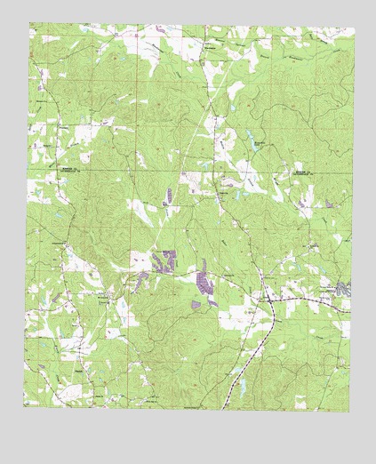
Daleville, MS USGS Topographic Map
Click on map above to begin viewing in our Map Viewer.

This topographic map contains these locations and features:
Feature Name Type Latitude Longitude GNIS ID View Map
A C Munn Pond DamDamN32.5185°W88.7334°681459View Map
Andrews ChapelChurchN32.5007°W88.6828°666268View Map
Andrews Chapel CemeteryCemeteryN32.5007°W88.6831°706365View Map
Antioch ChurchChurchN32.5535°W88.6412°666311View Map
Arkadelphia CemeteryCemeteryN32.5537°W88.7356°706366View Map
Arkadelphia ChurchChurchN32.5535°W88.7350°666365View Map
Bailey ChurchChurchN32.5038°W88.7225°666457View Map
Baker CreekStreamN32.5296°W88.6506°666471View Map
Bethel ChurchChurchN32.5851°W88.7409°666919View Map
Bill Daniels Catfish Ponds DamDamN32.5335°W88.7367°681471View Map
BlackwaterPopulated PlaceN32.6190°W88.6825°691539View Map
Blackwater Baptist ChurchChurchN32.6168°W88.6834°707937View Map
Blackwater CemeteryCemeteryN32.6162°W88.6828°707938View Map
Chomontakali (historical)Populated PlaceN32.6237°W88.7250°707948View Map
Cliff Walker Pond DamDamN32.5068°W88.6667°681449View Map
Coosha (historical)LocaleN32.5176°W88.6903°706373View Map
Cotes Mill (historical)LocaleN32.5662°W88.6456°683987View Map
Covington Fish Ponds DamDamN32.5351°W88.6834°681472View Map
Covington Fish Ponds DamDamN32.5468°W88.6917°681487View Map
Covington Fish Ponds DamDamN32.5468°W88.6967°681488View Map
DalevillePopulated PlaceN32.5699°W88.6762°669077View Map
Daleville CemeteryCemeteryN32.5437°W88.6584°669078View Map
Daleville CemeteryCemeteryN32.5676°W88.6753°706374View Map
Daleville Methodist ChurchChurchN32.5682°W88.6753°706375View Map
Daleville Post OfficePost OfficeN32.5701°W88.6769°2768747View Map
Doctor Dawson Pond DamDamN32.5501°W88.6834°681491View Map
Doctor L Rush Lake DamDamN32.5435°W88.7017°681483View Map
E H Motley Junior Lake DamDamN32.5618°W88.7384°681505View Map
Ebenezer ChurchChurchN32.5996°W88.7428°669646View Map
Hickory Grove Baptist ChurchChurchN32.5404°W88.6309°671165View Map
Hickory Grove CemeteryCemeteryN32.5368°W88.6325°671156View Map
Kempdale LakeReservoirN32.5861°W88.6631°672092View Map
Kempdale Lake DamDamN32.5901°W88.6650°681522View Map
LizeliaPopulated PlaceN32.5357°W88.6600°692008View Map
Mineral Springs BranchStreamN32.6146°W88.6537°673669View Map
Mosley BranchStreamN32.5665°W88.6492°673867View Map
Mount Carmel CemeteryCemeteryN32.5374°W88.7184°706386View Map
Mount Carmel ChurchChurchN32.5365°W88.7184°673957View Map
ObadiahPopulated PlaceN32.5124°W88.7267°694247View Map
PrismaticPopulated PlaceN32.5918°W88.7384°692159View Map
R N McElroy Pond DamDamN32.5668°W88.6334°681510View Map
Sam Dale Volunteer Fire Department and RescueBuildingN32.5715°W88.6775°2667898View Map
Samuel Dale CemeteryCemeteryN32.5512°W88.7000°677313View Map
Seals BranchStreamN32.6179°W88.6334°677484View Map
Tabernacle ChurchChurchN32.5438°W88.6742°678530View Map
Temple Pond DamDamN32.5235°W88.7400°681464View Map
White Oak ChurchChurchN32.5024°W88.7034°679601View Map
Whites Store (historical)LocaleN32.5246°W88.7125°684056View Map

Note: Coordinates in the location and feature list above are referenced to NAD83 datum.


Copyright (C) 2008-2025 Ryan Niemi / Sunset Dynamics ... All Rights Reserved