TopoQuest Logo
Do you find TopoQuest useful?
Help keep TopoQuest running and adding new maps/features by donating!
Bitcoin:  19c7KJd3qBynnjoSw5npx9KScwjBe4ifkT
Litecoin:  LXs6TkuXGGXo1vDsWCkWVdjQX94eUKd6ui
Home View Maps Find Maps Find Places Resources & Links


Lazear, Colorado Topographic Map

USGS Map Title: Lazear, CO
USGS Map MRC: 38107G7
DRG (GeoTIFF) Download: o38107g7.tif


Neighboring USGS Topographic Map Quads:


  Cedaredge, CO  
38107H8
 

  Dry Creek, CO  
38107H7
 

  Gray Reservoir, CO  
38107H6
 

  Orchard City, CO  
38107G8
 

  Lazear, CO  
38107G7
 

  Hotchkiss, CO  
38107G6
 

  Olathe NW, CO  
38107F8
 

  Black Ridge, CO  
38107F7
 

  Grand View Mesa, CO  
38107F6


Map MRC Location:

N39°
W108°
N39°
W107°
H8 H7 H6 H5 H4 H3 H2 H1
G8 G7 G6 G5 G4 G3 G2 G1
F8 F7 F6 F5 F4 F3 F2 F1
E8 E7 E6 E5 E4 E3 E2 E1
D8 D7 D6 D5 D4 D3 D2 D1
C8 C7 C6 C5 C4 C3 C2 C1
B8 B7 B6 B5 B4 B3 B2 B1
A8 A7 A6 A5 A4 A3 A2 A1
N38°
W108°
N38°
W107°

Lazear, CO USGS 1:24K Topographic Map Preview:
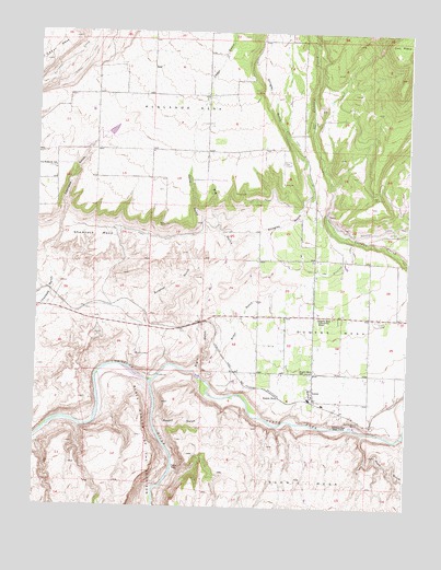
Lazear, CO USGS Topographic Map
Click on map above to begin viewing in our Map Viewer.

This topographic map contains these locations and features:
Feature Name Type Latitude Longitude GNIS ID View Map
Allen GulchValleyN38.7845°W107.8197°186511View Map
Alum GulchValleyN38.7696°W107.7645°186517View Map
Big GulchValleyN38.7856°W107.8216°186512View Map
Black Canyon of the GunnisonValleyN38.7832°W107.8366°186506View Map
Cedar FlatsFlatN38.7597°W107.8273°186508View Map
Cedar GulchValleyN38.8239°W107.8187°186270View Map
Cridler FieldAirportN38.8487°W107.8339°2443904View Map
Delta CountyCivilN38.8614°W107.8629°198130View Map
Durkee DitchCanalN38.8664°W107.8595°203210View Map
Eden Ranch AirportAirportN38.8370°W107.8661°204446View Map
Flying W Ranch AirportAirportN38.8624°W107.8199°204302View Map
Gunnison Forks MineMineN38.7819°W107.8409°1745549View Map
Highline DitchCanalN38.8525°W107.7914°203209View Map
Hurst School (historical)SchoolN38.8005°W107.7817°1795296View Map
LazearPopulated PlaceN38.7800°W107.7817°186514View Map
Lazear Post OfficePost OfficeN38.7795°W107.7818°1795143View Map
Montemadeira II AirportAirportN38.8051°W107.7752°2443906View Map
Mountain View Bible ChurchChurchN38.7811°W107.7823°1795142View Map
North Fork Gunnison RiverStreamN38.7828°W107.8367°186323View Map
Oasis DitchCanalN38.8208°W107.8353°203230View Map
Omega 1 AirportAirportN38.8352°W107.8152°2443905View Map
Paulson DamDamN38.8500°W107.8573°199282View Map
Paulson ReservoirReservoirN38.8489°W107.8500°199283View Map
Rabbit GulchValleyN38.7737°W107.8349°186509View Map
Rainbow Run Trout FarmLocaleN38.7717°W107.7703°186515View Map
Redlands AirportAirportN38.8421°W107.7928°204449View Map
Redlands MesaSummitN38.8569°W107.8226°203206View Map
Rogers MesaPopulated PlaceN38.7792°W107.7931°186510View Map
Rogers MesaSummitN38.7967°W107.7798°203232View Map
Rogers Mesa Community HouseLocaleN38.8000°W107.7806°186518View Map
Rogers Mesa Community HouseBuildingN38.8005°W107.7817°1795295View Map
Rogers Mesa SchoolLocaleN38.7855°W107.7823°186513View Map
Shamrock MesaSummitN38.8214°W107.8548°186519View Map
Spruce Point Tree Farm LLC AirportAirportN38.8346°W107.8593°204258View Map
Stingley GulchValleyN38.8188°W107.8103°186271View Map
Sulphur GulchValleyN38.7984°W107.8401°186521View Map
Sulphur MineMineN38.7903°W107.8412°186507View Map
Tommy Dowell SpringSpringN38.7726°W107.7661°186516View Map
West Redlands SchoolLocaleN38.8394°W107.8695°186520View Map

Note: Coordinates in the location and feature list above are referenced to NAD83 datum.


Copyright (C) 2008-2024 Ryan Niemi / Sunset Dynamics ... All Rights Reserved