TopoQuest Logo
Do you find TopoQuest useful?
Help keep TopoQuest running and adding new maps/features by donating!
Bitcoin:  19c7KJd3qBynnjoSw5npx9KScwjBe4ifkT
Litecoin:  LXs6TkuXGGXo1vDsWCkWVdjQX94eUKd6ui
Home View Maps Find Maps Find Places Resources & Links


Orchard City, Colorado Topographic Map

USGS Map Title: Orchard City, CO
USGS Map MRC: 38107G8
DRG (GeoTIFF) Download: o38107g8.tif


Neighboring USGS Topographic Map Quads:


  Hells Kitchen, CO  
38108H1
 

  Cedaredge, CO  
38107H8
 

  Dry Creek, CO  
38107H7
 

  North Delta, CO  
38108G1
 

  Orchard City, CO  
38107G8
 

  Lazear, CO  
38107G7
 

  Delta, CO  
38108F1
 

  Olathe NW, CO  
38107F8
 

  Black Ridge, CO  
38107F7


Map MRC Location:

N39°
W108°
N39°
W107°
H8 H7 H6 H5 H4 H3 H2 H1
G8 G7 G6 G5 G4 G3 G2 G1
F8 F7 F6 F5 F4 F3 F2 F1
E8 E7 E6 E5 E4 E3 E2 E1
D8 D7 D6 D5 D4 D3 D2 D1
C8 C7 C6 C5 C4 C3 C2 C1
B8 B7 B6 B5 B4 B3 B2 B1
A8 A7 A6 A5 A4 A3 A2 A1
N38°
W108°
N38°
W107°

Orchard City, CO USGS 1:24K Topographic Map Preview:
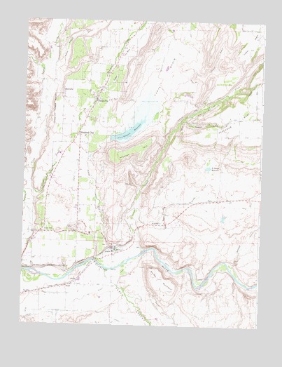
Orchard City, CO USGS Topographic Map
Click on map above to begin viewing in our Map Viewer.

This topographic map contains these locations and features:
Feature Name Type Latitude Longitude GNIS ID View Map
Adobe Buttes Sanitary LandfillLocaleN38.8192°W107.9950°2677958View Map
Alfalfa DitchCanalN38.8616°W107.9273°203203View Map
Alfalfa RunStreamN38.7783°W107.9609°186502View Map
Antelope HillSummitN38.8264°W107.9331°186499View Map
AustinPopulated PlaceN38.7811°W107.9509°203944View Map
Austin Post OfficePost OfficeN38.7813°W107.9523°204640View Map
Bona Fide DitchCanalN38.7636°W107.9923°203070View Map
Cedar RunStreamN38.7772°W107.9623°186503View Map
CoryPopulated PlaceN38.7880°W107.9873°203943View Map
Cory CemeteryCemeteryN38.7907°W107.9897°2045051View Map
Cory Post OfficePost OfficeN38.7890°W107.9892°204642View Map
Crim CemeteryCemeteryN38.7675°W107.9484°186486View Map
Currant CreekStreamN38.7803°W107.9367°175354View Map
Davis and Spaulding Property MineMineN38.7775°W107.9476°1745546View Map
Doughspoon CreekStreamN38.8114°W107.9978°185285View Map
Dry CreekStreamN38.7875°W107.9390°186493View Map
E O LateralCanalN38.7608°W107.9301°186505View Map
EckertPopulated PlaceN38.8428°W107.9628°186504View Map
Eckert CemeteryCemeteryN38.8466°W107.9592°2045055View Map
Eckert Post OfficePost OfficeN38.8363°W107.9663°2759190View Map
Fairview SchoolSchoolN38.7880°W107.9723°186485View Map
Fruit Growers DamDamN38.8266°W107.9556°200698View Map
Fruit Growers ReservoirReservoirN38.8295°W107.9454°186500View Map
Fuller Ditch Number 2CanalN38.7980°W107.9448°186501View Map
G K B LateralCanalN38.7514°W107.9528°186482View Map
G K LateralCanalN38.7536°W107.9520°186489View Map
Gallant DitchCanalN38.8428°W107.9012°186496View Map
Gunnison River Farms AirportAirportN38.7785°W107.9006°2770681View Map
Hallenbeck PitMineN38.7950°W107.9712°1745547View Map
Happy Hollow GulchValleyN38.8465°W107.9892°186248View Map
Harts BasinBasinN38.8530°W107.9273°203205View Map
Harts BasinReservoirN38.8266°W107.9556°200699View Map
Hawkins Ranch Airport (historical)AirportN38.8414°W107.8762°204447View Map
Highline DitchCanalN38.8666°W107.9123°203204View Map
Lawhead GulchValleyN38.7751°W107.8891°186490View Map
Madison GulchValleyN38.8342°W107.9159°186494View Map
Morton DitchCanalN38.8350°W107.9128°186498View Map
Oak CreekStreamN38.8558°W107.9926°185290View Map
Oasis DamDamN38.7933°W107.8956°199264View Map
Oasis ReservoirReservoirN38.7945°W107.8944°199265View Map
Orchard CityPopulated PlaceN38.8283°W107.9709°203073View Map
PaynePopulated PlaceN38.8017°W107.9020°186492View Map
Peach ValleyValleyN38.7663°W107.9510°186488View Map
Posin GulchValleyN38.8525°W107.9159°186497View Map
ReadPopulated PlaceN38.7661°W107.9762°186483View Map
Read CemeteryCemeteryN38.7556°W107.9810°2045057View Map
Saint George DamDamN38.8144°W107.9031°199376View Map
Saint George ReservoirReservoirN38.8150°W107.9031°186491View Map
SaxtonPopulated PlaceN38.7683°W107.9715°186484View Map
Smiths MountainSummitN38.7739°W107.9328°186487View Map
Surface CreekStreamN38.8028°W107.9984°175359View Map
Town of Orchard CityCivilN38.8140°W107.9708°2413088View Map
Transfer DitchCanalN38.8375°W107.9148°186495View Map
Widner AirportAirportN38.8338°W107.8925°204448View Map

Note: Coordinates in the location and feature list above are referenced to NAD83 datum.


Copyright (C) 2008-2025 Ryan Niemi / Sunset Dynamics ... All Rights Reserved