TopoQuest Logo
Do you find TopoQuest useful?
Help keep TopoQuest running and adding new maps/features by donating!
Bitcoin:  19c7KJd3qBynnjoSw5npx9KScwjBe4ifkT
Litecoin:  LXs6TkuXGGXo1vDsWCkWVdjQX94eUKd6ui
Home View Maps Find Maps Find Places Resources & Links


Lecontes Mills, Pennsylvania Topographic Map

USGS Map Title: Lecontes Mills, PA
USGS Map MRC: 41078A3
DRG (GeoTIFF) Download: o41078a3.tif


Neighboring USGS Topographic Map Quads:


  Huntley, PA  
41078B4
 

  The Knobs, PA  
41078B3
 

  Devils Elbow, PA  
41078B2
 

  Clearfield, PA  
41078A4
 

  Lecontes Mills, PA  
41078A3
 

  Frenchville, PA  
41078A2
 

  Glen Richey, PA  
40078H4
 

  Wallaceton, PA  
40078H3
 

  Philipsburg, PA  
40078H2


Map MRC Location:

N42°
W79°
N42°
W78°
H8 H7 H6 H5 H4 H3 H2 H1
G8 G7 G6 G5 G4 G3 G2 G1
F8 F7 F6 F5 F4 F3 F2 F1
E8 E7 E6 E5 E4 E3 E2 E1
D8 D7 D6 D5 D4 D3 D2 D1
C8 C7 C6 C5 C4 C3 C2 C1
B8 B7 B6 B5 B4 B3 B2 B1
A8 A7 A6 A5 A4 A3 A2 A1
N41°
W79°
N41°
W78°

Lecontes Mills, PA USGS 1:24K Topographic Map Preview:
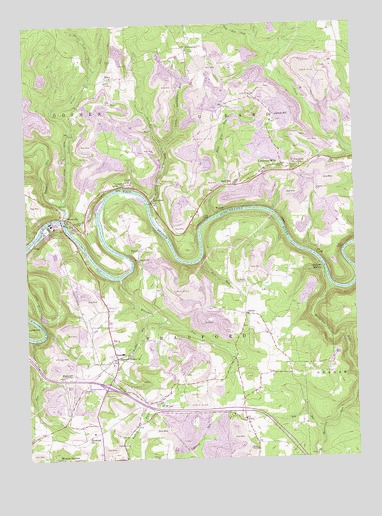
Lecontes Mills, PA USGS Topographic Map
Click on map above to begin viewing in our Map Viewer.

This topographic map contains these locations and features:
Feature Name Type Latitude Longitude GNIS ID View Map
Abes RunStreamN41.0353°W78.3728°1168029View Map
Bald HillPopulated PlaceN41.0798°W78.2931°1168632View Map
Bald Hill RunStreamN41.0698°W78.3025°1168640View Map
Bald Hill Station (historical)LocaleN41.0695°W78.3045°1206479View Map
Bear RunStreamN41.0570°W78.3083°1168922View Map
BishtownPopulated PlaceN41.0245°W78.3606°1203103View Map
Bloody RunStreamN41.0642°W78.3722°1169838View Map
Bradford ChurchChurchN41.0067°W78.3517°1170129View Map
Congress HillPopulated PlaceN41.0992°W78.2803°1172327View Map
Congress Hill CemeteryCemeteryN41.0772°W78.2644°1172328View Map
Congress Hill School (historical)SchoolN41.0767°W78.2645°1206480View Map
CoudleyLocaleN41.0742°W78.2503°1212745View Map
CroftPopulated PlaceN41.0789°W78.3345°1172707View Map
DalePopulated PlaceN41.0114°W78.2928°1172889View Map
Dale ChurchChurchN41.0126°W78.2970°1206474View Map
Dale RunStreamN41.0095°W78.2653°1172890View Map
Dale SchoolSchoolN41.0189°W78.2903°1206473View Map
EdenPopulated PlaceN41.1095°W78.3428°1173990View Map
EgyptPopulated PlaceN41.0606°W78.3314°1203498View Map
Egypt ChurchChurchN41.0573°W78.3317°1174046View Map
Gallows HarborPopulated PlaceN41.0559°W78.2628°1175396View Map
GillinghamPopulated PlaceN41.1173°W78.3128°1175619View Map
Girard Elementary SchoolSchoolN41.0842°W78.2700°1211698View Map
Goshen Elementary SchoolSchoolN41.0789°W78.3408°1211697View Map
Goshen Township Volunteer Fire Company Station 44BuildingN41.0718°W78.3532°2644996View Map
GrayLocaleN41.0612°W78.3722°1176018View Map
Hamilton HeliportAirportN41.0126°W78.2986°1213799View Map
Independence School (historical)SchoolN41.0134°W78.3595°1206476View Map
Jackson SchoolSchoolN41.0131°W78.3178°1206475View Map
Lecontes MillsPopulated PlaceN41.0831°W78.2833°1179108View Map
Lecontes Mills Volunteer Fire Company Station 21BuildingN41.0857°W78.2778°2645709View Map
Little Deer CreekStreamN41.1214°W78.2858°1179525View Map
Little Surveyor RunStreamN41.0906°W78.3222°1179692View Map
Little Trout RunStreamN41.0720°W78.3581°1179700View Map
Millstone RunStreamN41.0523°W78.3389°1181283View Map
Moravian RunStreamN41.0495°W78.2589°1181533View Map
Mount Sinai School (historical)SchoolN41.1037°W78.2864°1206481View Map
Murray CemeteryCemeteryN41.0831°W78.2736°1182104View Map
NeedfulPopulated PlaceN41.0309°W78.3417°1198231View Map
Pennsylvania State Police Troop C Clearfield StationBuildingN41.0096°W78.3457°2777327View Map
Pleasant Hill School (historical)SchoolN41.0381°W78.3445°1206477View Map
Pleasant Valley ChurchChurchN41.0292°W78.3409°1184073View Map
Shawviille Post OfficePost OfficeN41.0699°W78.3605°2779902View Map
ShawvillePopulated PlaceN41.0692°W78.3581°1187412View Map
ShilohPopulated PlaceN41.0417°W78.2914°1204636View Map
Shiloh CemeteryCemeteryN41.0510°W78.2912°1187517View Map
Stewart CemeteryCemeteryN41.0201°W78.3538°1188645View Map
Stump Lick RunStreamN41.1123°W78.3475°1188904View Map
Sulphur RunStreamN41.0428°W78.3311°1189009View Map
SurveyorPopulated PlaceN41.0739°W78.3256°1204778View Map
Surveyor RunStreamN41.0742°W78.3275°1189106View Map
Township of BradfordCivilN41.0209°W78.3240°1216227View Map
Trout RunStreamN41.0692°W78.3606°1189865View Map
WaltonPopulated PlaceN41.0717°W78.2995°1204896View Map
Watson School (historical)SchoolN41.0573°W78.3317°1206478View Map
Woodland Post OfficePost OfficeN41.0096°W78.3477°2780003View Map

Note: Coordinates in the location and feature list above are referenced to NAD83 datum.


Copyright (C) 2008-2025 Ryan Niemi / Sunset Dynamics ... All Rights Reserved