TopoQuest Logo
Do you find TopoQuest useful?
Help keep TopoQuest running and adding new maps/features by donating!
Bitcoin:  19c7KJd3qBynnjoSw5npx9KScwjBe4ifkT
Litecoin:  LXs6TkuXGGXo1vDsWCkWVdjQX94eUKd6ui
Home View Maps Find Maps Find Places Resources & Links


Glen Richey, Pennsylvania Topographic Map

USGS Map Title: Glen Richey, PA
USGS Map MRC: 40078H4
DRG (GeoTIFF) Download: o40078h4.tif


Neighboring USGS Topographic Map Quads:


  Elliott Park, PA  
41078A5
 

  Clearfield, PA  
41078A4
 

  Lecontes Mills, PA  
41078A3
 

  Curwensville, PA  
40078H5
 

  Glen Richey, PA  
40078H4
 

  Wallaceton, PA  
40078H3
 

  Irvona, PA  
40078G5
 

  Ramey, PA  
40078G4
 

  Houtzdale, PA  
40078G3


Map MRC Location:

N41°
W79°
N41°
W78°
H8 H7 H6 H5 H4 H3 H2 H1
G8 G7 G6 G5 G4 G3 G2 G1
F8 F7 F6 F5 F4 F3 F2 F1
E8 E7 E6 E5 E4 E3 E2 E1
D8 D7 D6 D5 D4 D3 D2 D1
C8 C7 C6 C5 C4 C3 C2 C1
B8 B7 B6 B5 B4 B3 B2 B1
A8 A7 A6 A5 A4 A3 A2 A1
N40°
W79°
N40°
W78°

Glen Richey, PA USGS 1:24K Topographic Map Preview:
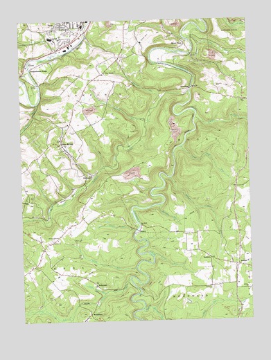
Glen Richey, PA USGS Topographic Map
Click on map above to begin viewing in our Map Viewer.

This topographic map contains these locations and features:
Feature Name Type Latitude Longitude GNIS ID View Map
Baughman CemeteryCemeteryN40.8889°W78.3967°1168817View Map
Believers Tabernacle Apostolic ChurchChurchN40.9895°W78.4678°1213536View Map
Bethlehem SchoolSchoolN40.9812°W78.3922°1169435View Map
BoardmanPopulated PlaceN40.8778°W78.4634°1169921View Map
Camp Hope RunStreamN40.9473°W78.4117°1171026View Map
Centre Grove ChurchChurchN40.9953°W78.4711°1213538View Map
Centre SchoolSchoolN40.9995°W78.4722°1213539View Map
Cherry RunStreamN40.9123°W78.4378°1171659View Map
Clearfield and Curwensville Country Club (historical)LocaleN40.9937°W78.4770°1213571View Map
Clearfield Area High SchoolSchoolN40.9926°W78.4820°1213537View Map
Clover HillSummitN40.9945°W78.4286°1172029View Map
Crown Crest Memorial ParkCemeteryN40.9953°W78.4691°1172776View Map
DevelingLocaleN40.9792°W78.4911°1201292View Map
DimelingLocaleN40.9717°W78.4072°1173279View Map
Dunlap RunStreamN40.8970°W78.4378°1173615View Map
Evergreen SchoolSchoolN40.9248°W78.4964°1174376View Map
FauncePopulated PlaceN40.9123°W78.4356°1174638View Map
Glen RicheyPopulated PlaceN40.9489°W78.4778°1175702View Map
Hartshorn RunStreamN40.9795°W78.4947°1176624View Map
Hogback RunStreamN40.9656°W78.4903°1177177View Map
JeffriesPopulated PlaceN40.8978°W78.3831°1213018View Map
Jeffries ChurchChurchN40.8887°W78.3767°1213534View Map
Jeffries SchoolSchoolN40.8887°W78.3770°1213574View Map
KellytownPopulated PlaceN40.8898°W78.4600°1178342View Map
KrebsPopulated PlaceN40.9851°W78.4070°1203964View Map
Laurel RunStreamN40.9676°W78.4222°1178986View Map
Lawrence Township Police DepartmentBuildingN40.9981°W78.4652°2781072View Map
Lawrence Township Volunteer Fire Company Station 7BuildingN40.9482°W78.4755°2645352View Map
Little Clearfield CreekStreamN40.9701°W78.4072°1179505View Map
Little Potts RunStreamN40.8867°W78.4553°1179651View Map
Litz BridgeBridgeN40.9862°W78.4053°1213535View Map
Long RunStreamN40.9920°W78.4070°1179892View Map
Lytle RunStreamN40.9017°W78.4284°1180144View Map
MitchellsLocaleN40.9342°W78.4622°1201291View Map
Morgan RunStreamN40.9592°W78.4036°1181551View Map
Mount HopePopulated PlaceN40.9901°W78.4095°1181705View Map
Mount Zion Memorial CemeteryCemeteryN40.9089°W78.4826°1213529View Map
Mount Zion Methodist ChurchChurchN40.9084°W78.4828°1214083View Map
New Birth ChurchChurchN40.9148°W78.4345°1213533View Map
Oshaniter Post Office (historical)Post OfficeN40.9376°W78.4906°1201290View Map
OshanterPopulated PlaceN40.9353°W78.4614°1183071View Map
Pine GrovePopulated PlaceN40.9789°W78.4531°1183795View Map
Pleasant Ridge School (historical)SchoolN40.9181°W78.4667°1213577View Map
Porters BridgeBridgeN40.9737°W78.4903°1184301View Map
Potts RunStreamN40.8920°W78.4411°1184350View Map
Raccoon RunStreamN40.9231°W78.4245°1184583View Map
SanbornPopulated PlaceN40.9012°W78.3972°1214094View Map
Sanborn CemeteryCemeteryN40.9022°W78.3988°1213531View Map
Sanborn Church of GodChurchN40.9017°W78.3970°1213530View Map
Sanborn RunStreamN40.9342°W78.4175°1214095View Map
Sanborn United Methodist ChurchChurchN40.9020°W78.3975°1213532View Map
Stoneville CemeteryCemeteryN40.9725°W78.3926°1188750View Map
StonvilleLocaleN40.9723°W78.3922°1206970View Map
Susquehanna BridgeLocaleN40.9806°W78.4936°1189110View Map
The NarrowsGapN40.9828°W78.4956°1189428View Map
Thompson CemeteryCemeteryN40.9544°W78.4707°1189497View Map
Township of KnoxCivilN40.8839°W78.4884°1216241View Map
Turkey Hill School (historical)SchoolN40.8976°W78.4936°1213580View Map
Upper Morgan RunStreamN40.8795°W78.4350°1190243View Map
Wallace RunStreamN40.9587°W78.4297°1190518View Map

Note: Coordinates in the location and feature list above are referenced to NAD83 datum.


Copyright (C) 2008-2024 Ryan Niemi / Sunset Dynamics ... All Rights Reserved