TopoQuest Logo
Do you find TopoQuest useful?
Help keep TopoQuest running and adding new maps/features by donating!
Bitcoin:  19c7KJd3qBynnjoSw5npx9KScwjBe4ifkT
Litecoin:  LXs6TkuXGGXo1vDsWCkWVdjQX94eUKd6ui
Home View Maps Find Maps Find Places Resources & Links


Wallaceton, Pennsylvania Topographic Map

USGS Map Title: Wallaceton, PA
USGS Map MRC: 40078H3
DRG (GeoTIFF) Download: o40078h3.tif


Neighboring USGS Topographic Map Quads:


  Clearfield, PA  
41078A4
 

  Lecontes Mills, PA  
41078A3
 

  Frenchville, PA  
41078A2
 

  Glen Richey, PA  
40078H4
 

  Wallaceton, PA  
40078H3
 

  Philipsburg, PA  
40078H2
 

  Ramey, PA  
40078G4
 

  Houtzdale, PA  
40078G3
 

  Sandy Ridge, PA  
40078G2


Map MRC Location:

N41°
W79°
N41°
W78°
H8 H7 H6 H5 H4 H3 H2 H1
G8 G7 G6 G5 G4 G3 G2 G1
F8 F7 F6 F5 F4 F3 F2 F1
E8 E7 E6 E5 E4 E3 E2 E1
D8 D7 D6 D5 D4 D3 D2 D1
C8 C7 C6 C5 C4 C3 C2 C1
B8 B7 B6 B5 B4 B3 B2 B1
A8 A7 A6 A5 A4 A3 A2 A1
N40°
W79°
N40°
W78°

Wallaceton, PA USGS 1:24K Topographic Map Preview:
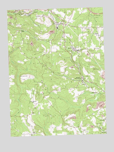
Wallaceton, PA USGS Topographic Map
Click on map above to begin viewing in our Map Viewer.

This topographic map contains these locations and features:
Feature Name Type Latitude Longitude GNIS ID View Map
ACCI HeliportAirportN40.9534°W78.2645°1213795View Map
Albert RunStreamN40.9126°W78.2583°1168116View Map
BiglerPopulated PlaceN40.9848°W78.3064°1169612View Map
Bigler Census Designated PlaceCensusN40.9888°W78.3097°2629996View Map
Bigler Jackson Woodland Volunteer Fire Company Station 16BuildingN40.9954°W78.3469°2645702View Map
Bigler Post OfficePost OfficeN40.9851°W78.3085°2772603View Map
Blue BallPopulated PlaceN40.9276°W78.2800°1214047View Map
Blue Ball SchoolSchoolN40.9292°W78.2831°1207327View Map
Borough of WallacetonCivilN40.9617°W78.2905°1215111View Map
Bradford Elementary SchoolSchoolN40.9848°W78.3025°1213551View Map
Bradford Refinery Mine Station (historical)LocaleN40.9917°W78.3175°1213598View Map
BurlyPopulated PlaceN40.8978°W78.3461°1213545View Map
BurlyLocaleN40.8973°W78.3464°1213024View Map
Butterworth Grove Free Methodist ChurchChurchN40.8851°W78.2561°1213544View Map
Center Hill CemeteryCemeteryN40.9713°W78.2545°1213552View Map
Center Hill Church (historical)ChurchN40.9714°W78.2545°1213570View Map
Center SchoolSchoolN40.8823°W78.2867°1171453View Map
Center SchoolSchoolN40.9570°W78.3189°1171454View Map
Centre United Methodist CemeteryCemeteryN40.8821°W78.2855°1213541View Map
Centre United Methodist ChurchChurchN40.8823°W78.2847°1213542View Map
DecaturvillePopulated PlaceN40.9151°W78.2614°1202119View Map
DranePopulated PlaceN40.8789°W78.2797°1173458View Map
Eagle Eye SchoolSchoolN40.9278°W78.3309°1173691View Map
Forcey RunStreamN40.9959°W78.3211°1174951View Map
Frans Airport (historical)AirportN40.8992°W78.2556°1194133View Map
GearhartvillePopulated PlaceN40.8892°W78.2514°1175496View Map
Goss CemeteryCemeteryN40.9157°W78.3381°1213549View Map
House of Prayer ChurchChurchN40.9092°W78.3475°1213547View Map
Jake RunStreamN40.9951°W78.3478°1177971View Map
Lake Street United Methodist ChurchChurchN40.9942°W78.3461°1213553View Map
Mineral SpringsPopulated PlaceN40.9981°W78.3636°1181319View Map
Mineral Springs Post OfficePost OfficeN40.9979°W78.3648°2779745View Map
Mokes Hill CemeteryCemeteryN40.9214°W78.2692°1213546View Map
Morgan Run (historical)LocaleN40.9131°W78.3309°1213599View Map
New CastlePopulated PlaceN40.8778°W78.3425°1213543View Map
New Castle School (historical)SchoolN40.8767°W78.3467°1213576View Map
New Castle United Methodist ChurchChurchN40.8762°W78.3461°1213540View Map
New LibertyPopulated PlaceN40.8773°W78.2506°1212659View Map
NewtownPopulated PlaceN40.9084°W78.3450°1182426View Map
Oak Grove United Methodist ChurchChurchN40.9242°W78.2761°1213550View Map
Ohio SchoolSchoolN40.9026°W78.3431°1182878View Map
Ohio United Methodist ChurchChurchN40.9026°W78.3425°1213548View Map
Pine TopPopulated PlaceN40.9926°W78.3306°1213023View Map
Salem ChurchChurchN40.9614°W78.3186°1186851View Map
Simeling RunStreamN40.9289°W78.2775°1187697View Map
SingletonLocaleN40.9737°W78.2575°1201293View Map
Spring ValleyPopulated PlaceN40.9795°W78.3572°1188279View Map
State Game Lands Number 98ParkN40.9334°W78.3581°1208047View Map
Summit Hill ChurchChurchN40.9645°W78.2506°1189046View Map
Township of BoggsCivilN40.9463°W78.3622°1216226View Map
Township of DecaturCivilN40.8836°W78.3066°1216232View Map
Valley Fork RunStreamN40.9989°W78.3370°1190302View Map
Van Mine StationLocaleN40.9542°W78.2697°1213025View Map
VictorPopulated PlaceN40.8803°W78.2578°1190397View Map
WallacetonPopulated PlaceN40.9598°W78.2889°1190524View Map
Wallaceton Boggs Elementary SchoolSchoolN40.9584°W78.2831°1207326View Map
Wallaceton Post OfficePost OfficeN40.9610°W78.2904°2773015View Map
Wallaceton Volunteer Fire Company Station 15BuildingN40.9601°W78.2879°2645697View Map
West DecaturPopulated PlaceN40.9284°W78.2781°1211956View Map
West Decatur Census Designated PlaceCensusN40.9290°W78.2827°2634276View Map
West Decatur Post OfficePost OfficeN40.9288°W78.2801°2773029View Map
WoodlandPopulated PlaceN40.9984°W78.3414°1191737View Map

Note: Coordinates in the location and feature list above are referenced to NAD83 datum.


Copyright (C) 2008-2024 Ryan Niemi / Sunset Dynamics ... All Rights Reserved