TopoQuest Logo
Do you find TopoQuest useful?
Help keep TopoQuest running and adding new maps/features by donating!
Bitcoin:  19c7KJd3qBynnjoSw5npx9KScwjBe4ifkT
Litecoin:  LXs6TkuXGGXo1vDsWCkWVdjQX94eUKd6ui
Home View Maps Find Maps Find Places Resources & Links


Clearfield, Pennsylvania Topographic Map

USGS Map Title: Clearfield, PA
USGS Map MRC: 41078A4
DRG (GeoTIFF) Download: o41078a4.tif


Neighboring USGS Topographic Map Quads:


  Penfield, PA  
41078B5
 

  Huntley, PA  
41078B4
 

  The Knobs, PA  
41078B3
 

  Elliott Park, PA  
41078A5
 

  Clearfield, PA  
41078A4
 

  Lecontes Mills, PA  
41078A3
 

  Curwensville, PA  
40078H5
 

  Glen Richey, PA  
40078H4
 

  Wallaceton, PA  
40078H3


Map MRC Location:

N42°
W79°
N42°
W78°
H8 H7 H6 H5 H4 H3 H2 H1
G8 G7 G6 G5 G4 G3 G2 G1
F8 F7 F6 F5 F4 F3 F2 F1
E8 E7 E6 E5 E4 E3 E2 E1
D8 D7 D6 D5 D4 D3 D2 D1
C8 C7 C6 C5 C4 C3 C2 C1
B8 B7 B6 B5 B4 B3 B2 B1
A8 A7 A6 A5 A4 A3 A2 A1
N41°
W79°
N41°
W78°

Clearfield, PA USGS 1:24K Topographic Map Preview:
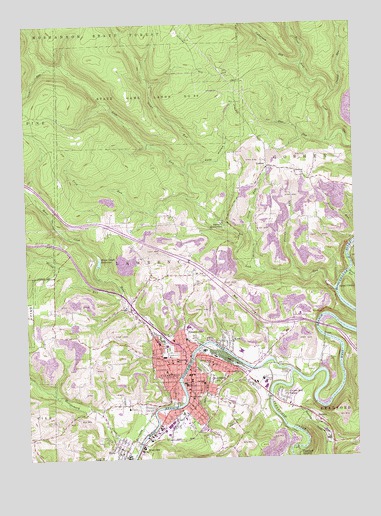
Clearfield, PA USGS Topographic Map
Click on map above to begin viewing in our Map Viewer.

This topographic map contains these locations and features:
Feature Name Type Latitude Longitude GNIS ID View Map
Baney SettlementPopulated PlaceN41.0681°W78.4247°1168684View Map
BarrettPopulated PlaceN41.0106°W78.3889°1168763View Map
Borough of ClearfieldCivilN41.0216°W78.4390°1215096View Map
Calvary CemeteryCemeteryN41.0060°W78.4314°1170919View Map
ClearfieldPopulated PlaceN41.0273°W78.4392°1213615View Map
Clearfield Area High SchoolSchoolN41.0339°W78.4489°1211703View Map
Clearfield Area Middle SchoolSchoolN41.0309°W78.4189°1211704View Map
Clearfield Borough Police DepartmentBuildingN41.0213°W78.4395°2781046View Map
Clearfield CountyCivilN41.0002°W78.4741°1209175View Map
Clearfield County Sheriff's OfficeBuildingN41.0223°W78.4375°2781073View Map
Clearfield CreekStreamN41.0248°W78.3986°1171976View Map
Clearfield Emergency Medical Services - Station 1BuildingN41.0319°W78.4371°2719664View Map
Clearfield HospitalHospitalN41.0330°W78.4497°2718022View Map
Clearfield JunctionPopulated PlaceN41.0012°W78.3972°1203283View Map
Clearfield Junior High School (historical)SchoolN41.0217°W78.4403°1214311View Map
Clearfield Post OfficePost OfficeN41.0241°W78.4384°2779835View Map
Clearfield Volunteer Fire Department - Station 1BuildingN41.0213°W78.4392°2645359View Map
Clearfield-Lawrence AirportAirportN41.0477°W78.4145°1194161View Map
Coldstream RunStreamN41.1134°W78.3942°1198051View Map
Cozy HollowValleyN41.0856°W78.4328°1172574View Map
Crooked RunStreamN41.1048°W78.3822°1172730View Map
Devils RunStreamN41.0531°W78.3764°1173210View Map
Flegals RunStreamN41.0539°W78.3975°1174895View Map
Fork RunStreamN41.0728°W78.4339°1174995View Map
Fourth Ward SchoolSchoolN41.0278°W78.4292°1175073View Map
Fulton CemeteryCemeteryN41.0285°W78.3849°1175331View Map
Golden Rod FarmsPopulated PlaceN41.0170°W78.4017°1175783View Map
GoshenPopulated PlaceN41.0837°W78.4078°1175845View Map
Goshen ChurchChurchN41.0812°W78.3928°1175847View Map
Goshen School (historical)SchoolN41.0834°W78.4072°1206488View Map
Hillcrest CemeteryCemeteryN41.0261°W78.4321°1177089View Map
Hillsdale SchoolSchoolN41.0231°W78.4286°1177110View Map
HydePopulated PlaceN41.0026°W78.4625°1177663View Map
Hyde Census Designated PlaceCensusN41.0075°W78.4689°2389965View Map
Hyde Post OfficePost OfficeN41.0035°W78.4626°2779612View Map
Hyde Volunteer Fire Company Station 6BuildingN41.0016°W78.4631°2645803View Map
Jerry RunStreamN41.0537°W78.4084°1178054View Map
Kerr AdditionPopulated PlaceN41.0337°W78.4231°1178404View Map
Lawrence Township Volunteer Fire Company Station 5BuildingN41.0341°W78.4465°2645026View Map
LeonardPopulated PlaceN41.0217°W78.4147°1201692View Map
Leonard Elementary SchoolSchoolN41.0217°W78.4322°1210648View Map
Lick RunStreamN41.0481°W78.3820°1179309View Map
Montgomery CreekStreamN41.0031°W78.4584°1181458View Map
Moose CreekStreamN41.0303°W78.4372°1181522View Map
Moose Creek ReservoirReservoirN41.0568°W78.4720°1181523View Map
Moose Creek Reservoir DamDamN41.0551°W78.4697°1195231View Map
Mount JoyPopulated PlaceN41.0528°W78.4359°1213247View Map
Mount ZionLocaleN41.0426°W78.4895°1212747View Map
Owens CemeteryCemeteryN41.0158°W78.4210°1183149View Map
ParadiseLocaleN41.0334°W78.4711°1206868View Map
Pine RunStreamN41.0909°W78.3839°1183880View Map
PlymptonvillePopulated PlaceN41.0459°W78.4456°1867504View Map
Plymptonville Census Designated PlaceCensusN41.0426°W78.4467°2389689View Map
Plymptonville Elementary SchoolSchoolN41.0342°W78.4442°1211702View Map
PlymtonvillePopulated PlaceN41.0359°W78.4395°1184141View Map
RiverviewPopulated PlaceN41.0039°W78.4559°1204520View Map
Roaring RunStreamN41.0112°W78.4034°1199393View Map
Saint Francis SchoolSchoolN41.0181°W78.4381°1185955View Map
State Game Lands Number 90ParkN41.1045°W78.4528°1193461View Map
Stone RunStreamN41.0828°W78.4386°1188738View Map
Third Ward Elementary SchoolSchoolN41.0309°W78.4189°1211705View Map
Third Ward Hose CompanyBuildingN41.0279°W78.4466°2645275View Map
Third Ward SchoolSchoolN41.0281°W78.4431°1189468View Map
Township of LawrenceCivilN41.0843°W78.4499°1216242View Map
WCPA-AM (Clearfield)TowerN41.0423°W78.4481°1200478View Map
Williams Dale School (historical)SchoolN41.0692°W78.3939°1206487View Map
Wolf RunStreamN41.0287°W78.4081°1191674View Map
Wolf Run School (historical)SchoolN41.0292°W78.4084°1206486View Map
Woods RunStreamN41.0473°W78.4622°1191767View Map
WPSX-TV (Clearfield)TowerN41.1226°W78.4409°1200554View Map
WQYX-FM (Clearfield)TowerN41.0423°W78.4481°1200276View Map

Note: Coordinates in the location and feature list above are referenced to NAD83 datum.


Copyright (C) 2008-2025 Ryan Niemi / Sunset Dynamics ... All Rights Reserved