TopoQuest Logo
Do you find TopoQuest useful?
Help keep TopoQuest running and adding new maps/features by donating!
Bitcoin:  19c7KJd3qBynnjoSw5npx9KScwjBe4ifkT
Litecoin:  LXs6TkuXGGXo1vDsWCkWVdjQX94eUKd6ui
Home View Maps Find Maps Find Places Resources & Links


Leesburg, Ohio Topographic Map

USGS Map Title: Leesburg, OH
USGS Map MRC: 39083C5
DRG (GeoTIFF) Download: o39083c5.tif


Neighboring USGS Topographic Map Quads:


  Sabina, OH  
39083D6
 

  Memphis, OH  
39083D5
 

  New Martinsburg, OH  
39083D4
 

  New Vienna, OH  
39083C6
 

  Leesburg, OH  
39083C5
 

  Greenfield, OH  
39083C4
 

  New Market, OH  
39083B6
 

  Hillsboro, OH  
39083B5
 

  Rainsboro, OH  
39083B4


Map MRC Location:

N40°
W84°
N40°
W83°
H8 H7 H6 H5 H4 H3 H2 H1
G8 G7 G6 G5 G4 G3 G2 G1
F8 F7 F6 F5 F4 F3 F2 F1
E8 E7 E6 E5 E4 E3 E2 E1
D8 D7 D6 D5 D4 D3 D2 D1
C8 C7 C6 C5 C4 C3 C2 C1
B8 B7 B6 B5 B4 B3 B2 B1
A8 A7 A6 A5 A4 A3 A2 A1
N39°
W84°
N39°
W83°

Leesburg, OH USGS 1:24K Topographic Map Preview:
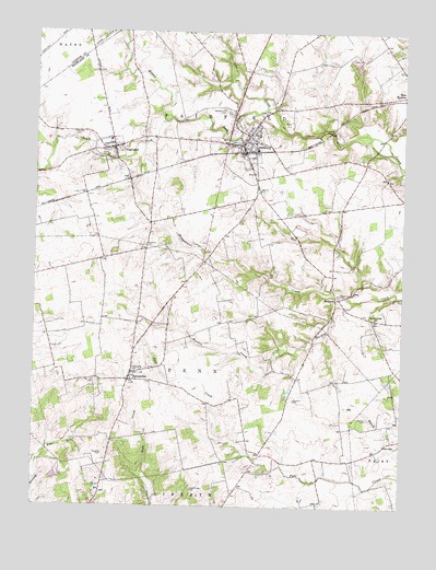
Leesburg, OH USGS Topographic Map
Click on map above to begin viewing in our Map Viewer.

This topographic map contains these locations and features:
Feature Name Type Latitude Longitude GNIS ID View Map
Antioch CemeteryCemeteryN39.3481°W83.6116°1037441View Map
Armco PondReservoirN39.3662°W83.5158°1078153View Map
Armco Pond DamDamN39.3667°W83.5166°1078152View Map
BridgesPopulated PlaceN39.3048°W83.5227°1062409View Map
Bridges Post Office (historical)Post OfficeN39.3042°W83.5221°2009670View Map
Bridgewater CreekStreamN39.3051°W83.5196°1038306View Map
Bull CreekStreamN39.3067°W83.5077°1038507View Map
Cemetery HillSummitN39.2828°W83.6049°1058557View Map
Clear Creek FarmsLocaleN39.2667°W83.5781°2724630View Map
Donner FieldAirportN39.3669°W83.5908°2442601View Map
Dunkard CemeteryCemeteryN39.3190°W83.5873°1039875View Map
Fairfield CemeteryCemeteryN39.3333°W83.5491°1040307View Map
Fairfield High SchoolSchoolN39.3459°W83.5508°1055306View Map
Fairfield Quaker Meeting HouseChurchN39.3328°W83.5494°1058560View Map
Fairfield-Highland Elementary SchoolSchoolN39.3462°W83.5996°1055307View Map
Hansbro School (historical)SchoolN39.2545°W83.5710°1053231View Map
Hansbrough CemeteryCemeteryN39.2545°W83.5694°1041293View Map
Hardin Creek CemeteryCemeteryN39.3056°W83.5219°1806553View Map
Hardin Creek ChurchChurchN39.2998°W83.5074°1061119View Map
Hattan FarmsLocaleN39.2856°W83.5103°2724609View Map
High Top CemeteryCemeteryN39.2831°W83.6030°1041551View Map
HighlandPopulated PlaceN39.3445°W83.5974°1064836View Map
Highland CemeteryCemeteryN39.3426°W83.6021°1806556View Map
Highland County North Joint Fire and Ambulance DistrictBuildingN39.3460°W83.5506°2550251View Map
Highland Post OfficePost OfficeN39.3445°W83.5971°2009703View Map
Highland StationPopulated PlaceN39.3359°W83.5933°1061242View Map
Johnson CemeteryCemeteryN39.2735°W83.5093°1042117View Map
Kornvolt Farms PondReservoirN39.2578°W83.6172°1078155View Map
Kornvolt Farms Pond DamDamN39.2567°W83.6183°1078154View Map
Leaverton CemeteryCemeteryN39.2781°W83.5349°1042461View Map
LeesburgPopulated PlaceN39.3451°W83.5530°1064980View Map
Leesburg Police DepartmentBuildingN39.3439°W83.5548°2732491View Map
Leesburg post officePost OfficeN39.3445°W83.5527°2009697View Map
Methodist CemeteryCemeteryN39.2864°W83.5860°1806563View Map
Middle Fork Lees CreekStreamN39.3548°W83.5458°1043274View Map
Mount Igorott School (historical)SchoolN39.3148°W83.5655°1053232View Map
Pleasant Hill CemeteryCemeteryN39.3537°W83.5577°1044541View Map
Roehm FarmsLocaleN39.2961°W83.6228°2724613View Map
Rosebush School (historical)SchoolN39.2706°W83.5135°1053236View Map
SamanthaPopulated PlaceN39.2834°W83.5919°1065284View Map
Samantha Freewill Baptist ChurchChurchN39.2912°W83.5913°1073260View Map
Samantha Post Office (historical)Post OfficeN39.2834°W83.5916°2009667View Map
School Number 3 (historical)SchoolN39.2662°W83.5463°1053237View Map
School Number 4 (historical)SchoolN39.3153°W83.6013°1053238View Map
Slickaway School (historical)SchoolN39.3678°W83.5802°1053240View Map
South Fork Lees CreekStreamN39.3512°W83.5802°1046465View Map
Swadley CemeteryCemeteryN39.2639°W83.6005°1046881View Map
Township of FairfieldCivilN39.3381°W83.5523°1086303View Map
Township of PennCivilN39.2916°W83.6015°1086311View Map
Union School (historical)SchoolN39.3003°W83.5260°1053241View Map
Village of HighlandCivilN39.3439°W83.6001°2398503View Map
Village of LeesburgCivilN39.3418°W83.5519°2398411View Map

Note: Coordinates in the location and feature list above are referenced to NAD83 datum.


Copyright (C) 2008-2024 Ryan Niemi / Sunset Dynamics ... All Rights Reserved