TopoQuest Logo
Do you find TopoQuest useful?
Help keep TopoQuest running and adding new maps/features by donating!
Bitcoin:  19c7KJd3qBynnjoSw5npx9KScwjBe4ifkT
Litecoin:  LXs6TkuXGGXo1vDsWCkWVdjQX94eUKd6ui
Home View Maps Find Maps Find Places Resources & Links


Margerum, Alabama Topographic Map

USGS Map Title: Margerum, AL
USGS Map MRC: 34088G1
DRG (GeoTIFF) Download: o34088g1.tif


Neighboring USGS Topographic Map Quads:


  Yellow Creek, MS  
34088H2
 

  Waterloo, AL  
34088H1
 

  Wright, AL  
34087H8
 

  Iuka, MS  
34088G2
 

  Margerum, AL  
34088G1
 

  Cherokee, AL  
34087G8
 

  Tishomingo, MS  
34088F2
 

  Bishop, AL  
34088F1
 

  Barton, AL  
34087F8


Map MRC Location:

N35°
W89°
N35°
W88°
H8 H7 H6 H5 H4 H3 H2 H1
G8 G7 G6 G5 G4 G3 G2 G1
F8 F7 F6 F5 F4 F3 F2 F1
E8 E7 E6 E5 E4 E3 E2 E1
D8 D7 D6 D5 D4 D3 D2 D1
C8 C7 C6 C5 C4 C3 C2 C1
B8 B7 B6 B5 B4 B3 B2 B1
A8 A7 A6 A5 A4 A3 A2 A1
N34°
W89°
N34°
W88°

Margerum, AL USGS 1:24K Topographic Map Preview:
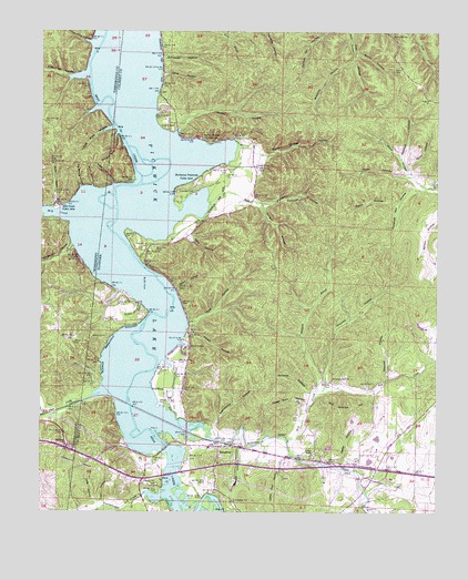
Margerum, AL USGS Topographic Map
Click on map above to begin viewing in our Map Viewer.

This topographic map contains these locations and features:
Feature Name Type Latitude Longitude GNIS ID View Map
Aurora SpringSpringN34.8462°W88.0723°157297View Map
Aurora Springs Cabin AreaLocaleN34.8465°W88.0717°151666View Map
Aurora Springs DockLocaleN34.8465°W88.0692°113282View Map
Barton HallBuildingN34.7508°W88.0028°2491758View Map
Bear Creek DockLocaleN34.7679°W88.0975°113678View Map
Bell Quarter HillSummitN34.7775°W88.0316°113864View Map
Bethune HollowValleyN34.8308°W88.0585°114161View Map
Bethune Hollow SpringSpringN34.8320°W88.0436°149272View Map
Big Spring HollowValleyN34.8343°W88.1126°667146View Map
Bone HollowValleyN34.8391°W88.0099°114721View Map
Booker BranchStreamN34.8290°W88.1212°667434View Map
Browns CreekStreamN34.7506°W88.0217°115013View Map
Buchanan Peninsula Cabin AreaLocaleN34.8370°W88.0748°151704View Map
Buck BranchStreamN34.8306°W88.0723°115103View Map
Buzzard RoostPopulated PlaceN34.7612°W88.0239°166015View Map
Buzzard Roost BridgeBridgeN34.7554°W88.0228°132824View Map
Buzzard Roost CreekStreamN34.7731°W88.0817°115334View Map
Buzzard Roost DockLocaleN34.7740°W88.0789°115335View Map
Buzzard Roost ParkParkN34.7748°W88.0820°148842View Map
Buzzard Roost Post OfficePost OfficeN34.7612°W88.0239°169244View Map
Buzzard Roost SpringSpringN34.7604°W88.0236°155429View Map
Canaan CemeteryCemeteryN34.7529°W88.0648°132828View Map
Cane HollowValleyN34.8634°W88.0872°115554View Map
Cary Church (historical)ChurchN34.8190°W88.0881°132829View Map
Cary HollowValleyN34.8223°W88.0789°115680View Map
Cary School (historical)SchoolN34.8195°W88.0828°132830View Map
Caryton (historical)Populated PlaceN34.8223°W88.0778°166016View Map
Caryton Post Office (historical)Post OfficeN34.8223°W88.0778°169246View Map
Carytown CemeteryCemeteryN34.8184°W88.0886°115681View Map
Chalk Mine HollowValleyN34.8722°W88.1097°668296View Map
ChiscaPopulated PlaceN34.7626°W88.0056°132837View Map
Clear CreekStreamN34.7792°W88.1106°116223View Map
Colbert County ParkParkN34.8540°W88.0875°116380View Map
Crenshaw CemeteryCemeteryN34.8342°W88.0770°116844View Map
Culbert Hollow SpringSpringN34.8203°W88.0770°132858View Map
Davis CemeteryCemeteryN34.8656°W88.0139°117118View Map
Davis HollowValleyN34.8302°W88.0121°117132View Map
Davis HollowValleyN34.8378°W88.0091°117133View Map
Doan HollowValleyN34.8079°W88.0827°117322View Map
Douthit CemeteryCemeteryN34.8498°W88.0839°117436View Map
Douthit ChurchChurchN34.8534°W88.0814°117437View Map
Douthit Methodist Church (historical)ChurchN34.8531°W88.0814°155431View Map
Douthit School (historical)SchoolN34.8523°W88.0831°132864View Map
Drisdale Chapel Church (historical)ChurchN34.7876°W88.0120°155435View Map
Drisdale School (historical)SchoolN34.7876°W88.0120°163958View Map
Durbin DitchValleyN34.8043°W88.0938°117691View Map
Fish Trap HollowValleyN34.8635°W88.1111°669992View Map
Fishtrap Ford (historical)CrossingN34.8615°W88.1098°689908View Map
Florence Mill HollowValleyN34.8342°W88.0046°118446View Map
Free Bridge (historical)BridgeN34.8156°W88.0939°141090View Map
Garrett CemeteryCemeteryN34.7837°W88.0198°118851View Map
Geise HollowValleyN34.7616°W88.0303°118885View Map
Ginhouse HollowValleyN34.8690°W88.0877°119002View Map
Goose Pond SloughGutN34.8515°W88.1000°150831View Map
Guthrie School (historical)SchoolN34.7831°W88.0242°132901View Map
Ham HollowValleyN34.7523°W88.1056°119613View Map
Hammond HollowValleyN34.7725°W88.0699°119657View Map
Happy HollowValleyN34.8485°W88.0831°119698View Map
Hayes HollowValleyN34.7974°W88.0784°119892View Map
Highpoint OverlookLocaleN34.8106°W88.0820°132913View Map
Hurd HollowValleyN34.7990°W88.0783°120563View Map
Hurd SpringSpringN34.7933°W88.0777°120564View Map
Ingleton (historical)Populated PlaceN34.7870°W88.0139°166020View Map
Ingleton Post Office (historical)Post OfficeN34.7870°W88.0139°169270View Map
Jackson CemeteryCemeteryN34.7956°W88.1045°120761View Map
Jackson Ridge Church (historical)ChurchN34.8037°W88.1037°132921View Map
Jackson Ridge School (historical)SchoolN34.8040°W88.1025°132922View Map
Jones HollowValleyN34.8376°W88.0089°121020View Map
Lee BranchStreamN34.8415°W88.0845°132935View Map
Lime KilnPopulated PlaceN34.7651°W88.0392°152064View Map
Lime Kiln HollowValleyN34.7644°W88.0461°121636View Map
Long HollowValleyN34.7518°W88.1067°122008View Map
MargerumPopulated PlaceN34.7670°W88.0684°152224View Map
Margerum SchoolSchoolN34.7668°W88.0717°132952View Map
Margerum United Methodist ChurchChurchN34.7670°W88.0681°132953View Map
McCabe HollowValleyN34.7810°W88.0403°122453View Map
Mill CreekStreamN34.7687°W88.0467°122802View Map
Mill CreekStreamN34.8320°W88.1056°673630View Map
Mill Creek Cabin AreaLocaleN34.8301°W88.1200°673632View Map
Mill Creek DockLocaleN34.8298°W88.1178°683129View Map
Moody BranchStreamN34.7751°W88.1237°673753View Map
Morgan HollowValleyN34.8305°W88.0570°123047View Map
Morris Hill CemeteryCemeteryN34.7574°W88.0882°123085View Map
Morris Hill Full Gospel Pentecostal ChurchChurchN34.7570°W88.0889°132961View Map
Mount Zion African Methodist Episcopal ChurchChurchN34.7643°W88.0389°150860View Map
Null HollowValleyN34.8346°W88.1092°674988View Map
O Canaan ChurchChurchN34.7531°W88.0642°124047View Map
Opossum BranchStreamN34.7820°W88.0373°152816View Map
Opossum HollowValleyN34.7827°W88.0372°132989View Map
Pegram (historical)LocaleN34.7793°W88.1000°155430View Map
Pennywinkle CreekStreamN34.7543°W88.0870°675596View Map
Pleasant Hill Freewill Methodist ChurchChurchN34.7845°W88.0325°153004View Map
Riverton JunctionLocaleN34.7709°W88.0775°166027View Map
Riverton Junction Post OfficePost OfficeN34.7709°W88.0775°169304View Map
Rosebud (historical)LocaleN34.7695°W88.1181°689972View Map
Rosetrail Hunting ClubLocaleN34.8604°W88.0867°133014View Map
Rosetrail ParkParkN34.8543°W88.0870°146256View Map
Scrabble Hill School (historical)SchoolN34.8615°W88.0870°133023View Map
Scufflehill Methodist Church (historical)ChurchN34.8615°W88.0870°155432View Map
Shingle Yard HollowValleyN34.8486°W88.1012°126767View Map
Smith HollowValleyN34.8694°W88.0263°127024View Map
Spencer HollowValleyN34.7847°W88.0155°127184View Map
Spencer HollowValleyN34.8421°W88.0118°127185View Map
Spout SpringSpringN34.8740°W88.0146°127200View Map
Spring BranchStreamN34.8640°W88.1098°141089View Map
Spring Valley DockLocaleN34.7934°W88.0809°127271View Map
State Line HollowValleyN34.8350°W88.1025°127329View Map
Stemeni Ford (historical)CrossingN34.7673°W88.0850°133045View Map
Sweet Gum HollowValleyN34.7783°W88.0406°127581View Map
Thomas HollowValleyN34.7832°W88.0347°127869View Map
Union Grove Church of ChristChurchN34.8398°W88.0575°153785View Map
Union Grove School (historical)SchoolN34.8401°W88.0581°133056View Map
Upper Field HollowValleyN34.8500°W88.1024°679147View Map
Walker (historical)Populated PlaceN34.8390°W88.0667°166029View Map
Walker Chapel HollowValleyN34.8428°W88.0543°128513View Map
Walker Post Office (historical)Post OfficeN34.8390°W88.0667°169314View Map
Williams HollowValleyN34.8675°W88.0271°129023View Map
Wimbish HollowValleyN34.8196°W88.1152°679781View Map

Note: Coordinates in the location and feature list above are referenced to NAD83 datum.


Copyright (C) 2008-2025 Ryan Niemi / Sunset Dynamics ... All Rights Reserved