TopoQuest Logo
Do you find TopoQuest useful?
Help keep TopoQuest running and adding new maps/features by donating!
Bitcoin:  19c7KJd3qBynnjoSw5npx9KScwjBe4ifkT
Litecoin:  LXs6TkuXGGXo1vDsWCkWVdjQX94eUKd6ui
Home View Maps Find Maps Find Places Resources & Links


Linden, Pennsylvania Topographic Map

USGS Map Title: Linden, PA
USGS Map MRC: 41077B2
DRG (GeoTIFF) Download: o41077b2.tif


Neighboring USGS Topographic Map Quads:


  Waterville, PA  
41077C3
 

  Salladasburg, PA  
41077C2
 

  Cogan Station, PA  
41077C1
 

  Jersey Shore, PA  
41077B3
 

  Linden, PA  
41077B2
 

  Williamsport, PA  
41077B1
 

  Loganton, PA  
41077A3
 

  Carroll, PA  
41077A2
 

  Williamsport SE, PA  
41077A1


Map MRC Location:

N42°
W78°
N42°
W77°
H8 H7 H6 H5 H4 H3 H2 H1
G8 G7 G6 G5 G4 G3 G2 G1
F8 F7 F6 F5 F4 F3 F2 F1
E8 E7 E6 E5 E4 E3 E2 E1
D8 D7 D6 D5 D4 D3 D2 D1
C8 C7 C6 C5 C4 C3 C2 C1
B8 B7 B6 B5 B4 B3 B2 B1
A8 A7 A6 A5 A4 A3 A2 A1
N41°
W78°
N41°
W77°

Linden, PA USGS 1:24K Topographic Map Preview:
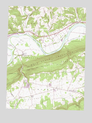
Linden, PA USGS Topographic Map
Click on map above to begin viewing in our Map Viewer.

This topographic map contains these locations and features:
Feature Name Type Latitude Longitude GNIS ID View Map
Antes CreekStreamN41.1890°W77.2408°1168331View Map
Antes FortPopulated PlaceN41.1917°W77.2239°1192073View Map
Antes Fort Post OfficePost OfficeN41.1924°W77.2244°2773065View Map
Antes Fort Volunteer Fire CompanyBuildingN41.1910°W77.2263°2652853View Map
BastressPopulated PlaceN41.1759°W77.1372°1168800View Map
Big RunStreamN41.2037°W77.1597°1169567View Map
Canoe RunStreamN41.2473°W77.2261°1171176View Map
CollomsvillePopulated PlaceN41.1476°W77.1430°1172226View Map
Crane IslandIslandN41.2037°W77.2002°1172640View Map
Ecktown SchoolSchoolN41.1556°W77.2011°1197043View Map
Fort Antes CemeteryCemeteryN41.1912°W77.2383°1175005View Map
Garrett Airport (historical)AirportN41.1445°W77.1547°1194180View Map
Hinaman Acres AirportAirportN41.1322°W77.2054°1194175View Map
Jersey Shore AirportAirportN41.2056°W77.2279°1194193View Map
Jersey Shore StationLocaleN41.1906°W77.2252°1197044View Map
Larrys CreekStreamN41.2167°W77.2202°1198998View Map
Larrys CreekPopulated PlaceN41.2195°W77.2136°1178898View Map
LarryvillePopulated PlaceN41.2398°W77.2172°1178900View Map
Level CornerPopulated PlaceN41.2020°W77.1880°1204017View Map
Level Corner SchoolSchoolN41.2023°W77.1883°1197048View Map
Limestone CemeteryCemeteryN41.1392°W77.2294°2043468View Map
LindenPopulated PlaceN41.2309°W77.1394°1179406View Map
Linden Post OfficePost OfficeN41.2309°W77.1388°2772796View Map
Linden StationLocaleN41.2304°W77.1389°1212564View Map
Little Pine RunStreamN41.2242°W77.1819°1179638View Map
Long IslandIslandN41.2023°W77.2469°1179861View Map
Maranatha ChurchChurchN41.2148°W77.1880°1180383View Map
Martins SchoolSchoolN41.2220°W77.2016°1197046View Map
McMurrin RunStreamN41.1387°W77.1914°1180791View Map
Morgan Valley RunStreamN41.1745°W77.2255°1181553View Map
Morgan Valley School (historical)SchoolN41.1787°W77.1864°1197050View Map
Mount Zion ChurchChurchN41.2170°W77.2080°1181936View Map
New Tribes InstituteSchoolN41.2362°W77.2166°1182376View Map
Nippenose Valley Elementary SchoolSchoolN41.1490°W77.1597°1207727View Map
Nippenose Valley Fire CompanyBuildingN41.1528°W77.1776°2652800View Map
Nippenose Valley Volunteer Fire Company Station 2BuildingN41.1307°W77.2351°2645587View Map
Nippono Park (historical)Populated PlaceN41.1904°W77.1933°1197049View Map
OriolePopulated PlaceN41.1412°W77.2100°1213420View Map
OvalPopulated PlaceN41.1512°W77.1691°1183132View Map
Oval Census Designated PlaceCensusN41.1522°W77.1745°2634252View Map
Pennsylvania Game Commission Division OfficeBuildingN41.1912°W77.2325°1212565View Map
Pine Creek QuarryMineN41.1489°W77.2219°2706952View Map
Pine RunPopulated PlaceN41.2379°W77.1775°1183871View Map
Pine RunStreamN41.2148°W77.1566°1190988View Map
Quenshukeny RunStreamN41.2309°W77.1344°1193167View Map
Rattling Camp RunStreamN41.1476°W77.1383°1184685View Map
Rauchtown Census Designated PlaceCensusN41.1262°W77.2363°2634269View Map
Rauchtown CreekStreamN41.1381°W77.2261°1184701View Map
River Mill School (historical)SchoolN41.1909°W77.2369°1197045View Map
Saint James Limestone ChurchChurchN41.1387°W77.2286°1186029View Map
Saint Peters ChurchChurchN41.1484°W77.1466°1186680View Map
Seeley RunStreamN41.2406°W77.2152°1193315View Map
Stewards RunStreamN41.2145°W77.2314°1188644View Map
Toms Landing Strip (historical)AirportN41.2154°W77.2261°1194194View Map
Township of LimestoneCivilN41.1394°W77.1604°1216754View Map
Township of NippenoseCivilN41.1853°W77.2217°1216765View Map
Township of PiattCivilN41.2253°W77.2165°1216768View Map
Township of SusquehannaCivilN41.2108°W77.1260°1216773View Map
Township of WoodwardCivilN41.2377°W77.1462°1216778View Map
Whiteoak SchoolSchoolN41.2165°W77.1716°1197047View Map

Note: Coordinates in the location and feature list above are referenced to NAD83 datum.


Copyright (C) 2008-2024 Ryan Niemi / Sunset Dynamics ... All Rights Reserved