TopoQuest Logo
Do you find TopoQuest useful?
Help keep TopoQuest running and adding new maps/features by donating!
Bitcoin:  19c7KJd3qBynnjoSw5npx9KScwjBe4ifkT
Litecoin:  LXs6TkuXGGXo1vDsWCkWVdjQX94eUKd6ui
Home View Maps Find Maps Find Places Resources & Links


Salladasburg, Pennsylvania Topographic Map

USGS Map Title: Salladasburg, PA
USGS Map MRC: 41077C2
DRG (GeoTIFF) Download: o41077c2.tif


Neighboring USGS Topographic Map Quads:


  English Center, PA  
41077D3
 

  White Pine, PA  
41077D2
 

  Trout Run, PA  
41077D1
 

  Waterville, PA  
41077C3
 

  Salladasburg, PA  
41077C2
 

  Cogan Station, PA  
41077C1
 

  Jersey Shore, PA  
41077B3
 

  Linden, PA  
41077B2
 

  Williamsport, PA  
41077B1


Map MRC Location:

N42°
W78°
N42°
W77°
H8 H7 H6 H5 H4 H3 H2 H1
G8 G7 G6 G5 G4 G3 G2 G1
F8 F7 F6 F5 F4 F3 F2 F1
E8 E7 E6 E5 E4 E3 E2 E1
D8 D7 D6 D5 D4 D3 D2 D1
C8 C7 C6 C5 C4 C3 C2 C1
B8 B7 B6 B5 B4 B3 B2 B1
A8 A7 A6 A5 A4 A3 A2 A1
N41°
W78°
N41°
W77°

Salladasburg, PA USGS 1:24K Topographic Map Preview:
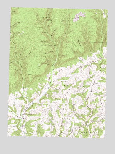
Salladasburg, PA USGS Topographic Map
Click on map above to begin viewing in our Map Viewer.

This topographic map contains these locations and features:
Feature Name Type Latitude Longitude GNIS ID View Map
Anthony CemeteryCemeteryN41.2973°W77.1700°1168332View Map
Anthony ChurchChurchN41.2940°W77.1558°1168333View Map
Borough of SalladasburgCivilN41.2783°W77.2273°1215426View Map
Chestnut Grove School (historical)SchoolN41.2687°W77.2044°1197464View Map
Citizens Hose Company SubstationBuildingN41.2767°W77.2267°2653558View Map
Clapp PointCapeN41.3109°W77.2208°1171892View Map
Coal MountainSummitN41.3517°W77.1647°1172060View Map
Cramer HollowValleyN41.3435°W77.1965°1172613View Map
De France HollowValleyN41.3480°W77.2465°1173007View Map
First Fork Larrys CreekStreamN41.2651°W77.2322°1174784View Map
Funston HollowValleyN41.3487°W77.2485°1202935View Map
Funston RunStreamN41.3487°W77.2480°1200083View Map
Greenwood School (historical)SchoolN41.3023°W77.1941°1197461View Map
Harbor RunStreamN41.3234°W77.2405°1176501View Map
Harris PointCapeN41.3201°W77.2014°1176576View Map
Jobes RunStreamN41.2654°W77.1477°1178091View Map
Joes RunStreamN41.2884°W77.2300°1178096View Map
Keiss School (historical)SchoolN41.2954°W77.1727°1197462View Map
Kline HollowValleyN41.3130°W77.2349°1178585View Map
Little Gap RunStreamN41.3251°W77.1305°1179553View Map
Little Harbor RunStreamN41.3204°W77.2366°1179559View Map
Little Sandy HollowValleyN41.3218°W77.2355°1179667View Map
Long RunStreamN41.3592°W77.2053°1179895View Map
Lumber Bridge SchoolSchoolN41.2542°W77.1433°1197469View Map
Lycoming ChurchChurchN41.2579°W77.1666°1180099View Map
Main Creek SchoolSchoolN41.2929°W77.2075°1197463View Map
Mash RunStreamN41.3226°W77.1908°1180524View Map
Match Pine HollowValleyN41.3514°W77.2020°1180542View Map
Mud RunStreamN41.2670°W77.2364°1182035View Map
Pond HollowValleyN41.3277°W77.1872°1184238View Map
Pot Lick HollowValleyN41.3476°W77.1968°1184320View Map
Roaring RunStreamN41.3337°W77.1891°1185185View Map
Saint Johns ChurchChurchN41.2773°W77.1775°1186162View Map
SalladasburgPopulated PlaceN41.2773°W77.2258°1186873View Map
Salladasburg Elementary SchoolSchoolN41.2676°W77.2297°1207726View Map
Second Fork Larrys CreekStreamN41.2815°W77.2230°1199964View Map
Spook HollowValleyN41.3326°W77.1904°1188189View Map
Stablers Grove Picnic AreaAreaN41.2865°W77.1830°1188375View Map
State Game Lands Number 114ParkN41.3379°W77.2005°1199592View Map
State Road ChurchChurchN41.3026°W77.1394°1188557View Map
State Road School (historical)SchoolN41.3037°W77.1391°1197467View Map
Steam Mill SchoolSchoolN41.2756°W77.1419°1197468View Map
Stony Gap RunStreamN41.3276°W77.1289°1188773View Map
Stony Gap SchoolSchoolN41.3209°W77.1519°1197466View Map
Township of AnthonyCivilN41.2952°W77.1681°1216738View Map
Township of MifflinCivilN41.2940°W77.2319°1216760View Map
Upper Pine Run School (historical)SchoolN41.2692°W77.1786°1197465View Map
Watt HollowValleyN41.3560°W77.2035°1190696View Map

Note: Coordinates in the location and feature list above are referenced to NAD83 datum.


Copyright (C) 2008-2025 Ryan Niemi / Sunset Dynamics ... All Rights Reserved