TopoQuest Logo
Do you find TopoQuest useful?
Help keep TopoQuest running and adding new maps/features by donating!
Bitcoin:  19c7KJd3qBynnjoSw5npx9KScwjBe4ifkT
Litecoin:  LXs6TkuXGGXo1vDsWCkWVdjQX94eUKd6ui
Home View Maps Find Maps Find Places Resources & Links


Jersey Shore, Pennsylvania Topographic Map

USGS Map Title: Jersey Shore, PA
USGS Map MRC: 41077B3
DRG (GeoTIFF) Download: o41077b3.tif


Neighboring USGS Topographic Map Quads:


  Jersey Mills, PA  
41077C4
 

  Waterville, PA  
41077C3
 

  Salladasburg, PA  
41077C2
 

  Lock Haven, PA  
41077B4
 

  Jersey Shore, PA  
41077B3
 

  Linden, PA  
41077B2
 

  Mill Hall, PA  
41077A4
 

  Loganton, PA  
41077A3
 

  Carroll, PA  
41077A2


Map MRC Location:

N42°
W78°
N42°
W77°
H8 H7 H6 H5 H4 H3 H2 H1
G8 G7 G6 G5 G4 G3 G2 G1
F8 F7 F6 F5 F4 F3 F2 F1
E8 E7 E6 E5 E4 E3 E2 E1
D8 D7 D6 D5 D4 D3 D2 D1
C8 C7 C6 C5 C4 C3 C2 C1
B8 B7 B6 B5 B4 B3 B2 B1
A8 A7 A6 A5 A4 A3 A2 A1
N41°
W78°
N41°
W77°

Jersey Shore, PA USGS 1:24K Topographic Map Preview:
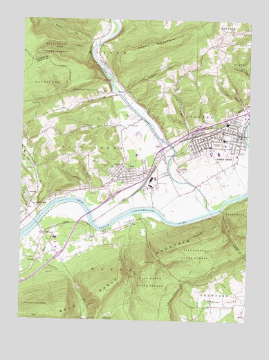
Jersey Shore, PA USGS Topographic Map
Click on map above to begin viewing in our Map Viewer.

This topographic map contains these locations and features:
Feature Name Type Latitude Longitude GNIS ID View Map
Aughanbaugh RunStreamN41.1709°W77.2639°1168505View Map
AvisPopulated PlaceN41.1848°W77.3139°1168522View Map
Avis Elementary SchoolSchoolN41.1940°W77.3114°1207725View Map
Avis Post OfficePost OfficeN41.1850°W77.3157°1953595View Map
Avis Volunteer Fire Company Station 8BuildingN41.1846°W77.3145°2645093View Map
Avis YardLocaleN41.1812°W77.3044°1168523View Map
Bald Eagle MountainRangeN41.1367°W77.3283°1190976View Map
Bellevue CemeteryCemeteryN41.1885°W77.3274°1169175View Map
Big Plum RunStreamN41.1692°W77.3653°1169544View Map
Borough of AvisCivilN41.1857°W77.3165°1215113View Map
Borough of Jersey ShoreCivilN41.2012°W77.2667°1215421View Map
Boyd Keller Reservoir DamDamN41.1251°W77.3347°1195288View Map
Brady SchoolSchoolN41.2128°W77.3455°1197480View Map
BrownsLocaleN41.1645°W77.3364°1197482View Map
Browns StationLocaleN41.1667°W77.3330°1212802View Map
Center SchoolSchoolN41.1592°W77.3347°1197483View Map
CharltonPopulated PlaceN41.1784°W77.3505°1171591View Map
Chatham RunPopulated PlaceN41.1715°W77.3653°1171613View Map
Chatham RunStreamN41.1681°W77.3644°1171614View Map
Citizens Hose Company of Jersey ShoreBuildingN41.2000°W77.2714°2652869View Map
CrestmontPopulated PlaceN41.1762°W77.3716°1172688View Map
Dennison HollowValleyN41.2059°W77.2690°1173158View Map
Dutch HollowValleyN41.2190°W77.3255°1173659View Map
Ferguson SchoolSchoolN41.1887°W77.2641°1197476View Map
Furnace RunStreamN41.2165°W77.3175°1175363View Map
Gamble RunStreamN41.2398°W77.3341°1192500View Map
Garman ChurchChurchN41.2067°W77.3150°1175455View Map
Garman SchoolSchoolN41.2073°W77.3116°1197477View Map
Gravel Hill SchoolSchoolN41.1942°W77.3428°1197481View Map
Harbor Mills School (historical)SchoolN41.2259°W77.3080°1197478View Map
Henry RunStreamN41.1695°W77.3091°1176844View Map
Independent Hose Company 1BuildingN41.2020°W77.2557°2653423View Map
Jersey ShoreBeachN41.2029°W77.2711°1192690View Map
Jersey ShorePopulated PlaceN41.2020°W77.2644°1213696View Map
Jersey Shore Area Elementary SchoolSchoolN41.1984°W77.2625°1207723View Map
Jersey Shore Area Junior High SchoolSchoolN41.2006°W77.2630°1207724View Map
Jersey Shore Area Senior High SchoolSchoolN41.2034°W77.2664°1207722View Map
Jersey Shore CemeteryCemeteryN41.1987°W77.2672°1178060View Map
Jersey Shore HospitalHospitalN41.2018°W77.2680°2718077View Map
Jersey Shore Post OfficePost OfficeN41.2029°W77.2549°2772764View Map
Keller ReservoirReservoirN41.1253°W77.3347°1178319View Map
Keller Reservoir DamDamN41.1252°W77.3388°1178320View Map
Kissel TrailTrailN41.1487°W77.2758°1192713View Map
Kryder HollowValleyN41.1807°W77.3415°1178699View Map
Kyler HollowValleyN41.1318°W77.2699°1178720View Map
Little Plum RunStreamN41.1678°W77.3708°1179642View Map
Love RunStreamN41.1690°W77.3103°1179986View Map
McElhattanPopulated PlaceN41.1598°W77.3614°1180705View Map
McElhattan Census Designated PlaceCensusN41.1572°W77.3617°2634238View Map
McElhattan Post OfficePost OfficeN41.1561°W77.3573°2772811View Map
Nepley ForkStreamN41.2415°W77.3380°1182249View Map
Nice HollowValleyN41.2139°W77.2529°1182434View Map
Nichols RunStreamN41.1953°W77.2897°1214668View Map
Nippenose ValleyValleyN41.1335°W77.2543°1182475View Map
Phelps ChapelChurchN41.1978°W77.2980°1183652View Map
PinePopulated PlaceN41.1665°W77.3141°1183757View Map
Pine CreekStreamN41.1712°W77.2689°1199304View Map
Pine Creek CemeteryCemeteryN41.1820°W77.2641°1183781View Map
Pine Creek GorgeValleyN41.2220°W77.3244°1200138View Map
Pine Creek Township Police DepartmentBuildingN41.1870°W77.3087°2780544View Map
Pine Station (historical)LocaleN41.1648°W77.3155°1197484View Map
Red SchoolSchoolN41.1315°W77.2561°1197485View Map
Refuge TrailTrailN41.1548°W77.2686°1193181View Map
Rich CemeteryCemeteryN41.1731°W77.3705°2777548View Map
Round TopSummitN41.1490°W77.3064°1193227View Map
Schultz ForkStreamN41.2484°W77.3603°1193300View Map
Short MountainRidgeN41.2381°W77.3091°1175206View Map
Short MountainSummitN41.2381°W77.3091°1183324View Map
South Avis SchoolSchoolN41.1823°W77.2994°1188010View Map
Sulphur RunStreamN41.2103°W77.3100°1189010View Map
Tiadaghton Valley MallLocaleN41.2040°W77.2577°1214602View Map
Tiadaghton Valley Regional Police DepartmentBuildingN41.2018°W77.2553°2780449View Map
TombPopulated PlaceN41.2484°W77.3272°1197479View Map
TorbertPopulated PlaceN41.2206°W77.3186°1204820View Map
Township of Pine CreekCivilN41.1926°W77.3355°1216268View Map
Township of PorterCivilN41.1883°W77.2778°1216771View Map
Township of WayneCivilN41.1388°W77.3286°1216270View Map
Wayne Township LandfillLocaleN41.1636°W77.3486°2725973View Map
Wayne Township Volunteer Fire Company Station 10BuildingN41.1514°W77.3658°2645581View Map
WJSA-AM (Jersey Shore)TowerN41.2256°W77.2666°1200489View Map
Woodys Field (historical)AirportN41.2001°W77.2830°1194189View Map
Woolrich ParkParkN41.1906°W77.3739°1191786View Map
WSQV-FM (Jersey Shore)TowerN41.2206°W77.2772°1200296View Map
YoungdalePopulated PlaceN41.1501°W77.3647°1191915View Map

Note: Coordinates in the location and feature list above are referenced to NAD83 datum.


Copyright (C) 2008-2025 Ryan Niemi / Sunset Dynamics ... All Rights Reserved