TopoQuest Logo
Do you find TopoQuest useful?
Help keep TopoQuest running and adding new maps/features by donating!
Bitcoin:  19c7KJd3qBynnjoSw5npx9KScwjBe4ifkT
Litecoin:  LXs6TkuXGGXo1vDsWCkWVdjQX94eUKd6ui
Home View Maps Find Maps Find Places Resources & Links


Linden, Tennessee Topographic Map

USGS Map Title: Linden, TN
USGS Map MRC: 35087E7
DRG (GeoTIFF) Download: o35087e7.tif


Neighboring USGS Topographic Map Quads:


  Pine View, TN  
35087F8
 

  Chestnut Grove, TN  
35087F7
 

  Pleasantville, TN  
35087F6
 

  Pope, TN  
35087E8
 

  Linden, TN  
35087E7
 

  Graves Spring, TN  
35087E6
 

  Clifton, TN  
35087D8
 

  Leatherwood, TN  
35087D7
 

  Topsy, TN  
35087D6


Map MRC Location:

N36°
W88°
N36°
W87°
H8 H7 H6 H5 H4 H3 H2 H1
G8 G7 G6 G5 G4 G3 G2 G1
F8 F7 F6 F5 F4 F3 F2 F1
E8 E7 E6 E5 E4 E3 E2 E1
D8 D7 D6 D5 D4 D3 D2 D1
C8 C7 C6 C5 C4 C3 C2 C1
B8 B7 B6 B5 B4 B3 B2 B1
A8 A7 A6 A5 A4 A3 A2 A1
N35°
W88°
N35°
W87°

Linden, TN USGS 1:24K Topographic Map Preview:
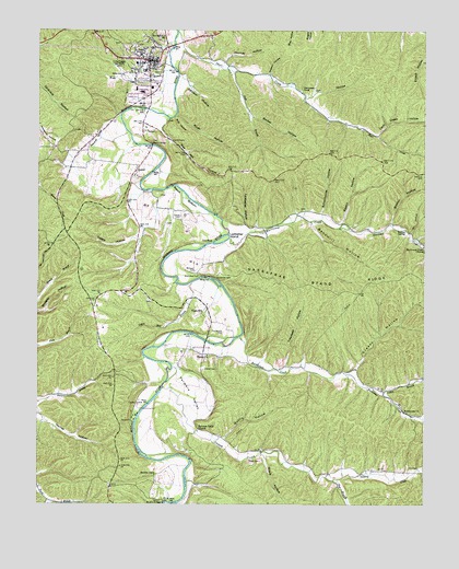
Linden, TN USGS Topographic Map
Click on map above to begin viewing in our Map Viewer.

This topographic map contains these locations and features:
Feature Name Type Latitude Longitude GNIS ID View Map
Ary CemeteryCemeteryN35.5098°W87.7547°1275916View Map
Bandmill HollowValleyN35.5747°W87.7869°1276258View Map
Barber HollowValleyN35.6024°W87.8060°1276283View Map
Baston HollowValleyN35.5743°W87.7766°1276443View Map
Beech BottomBendN35.5803°W87.8289°1276794View Map
BethelPopulated PlaceN35.5884°W87.8436°1277095View Map
Bethel BridgeBridgeN35.5948°W87.8386°1277102View Map
Bethel United Methodist ChurchChurchN35.5865°W87.8431°1325368View Map
Bird HollowValleyN35.6017°W87.8321°1277508View Map
Boiling SpringSpringN35.5726°W87.7567°1277886View Map
Bryson HollowValleyN35.5739°W87.7612°1278767View Map
Camp LindenLocaleN35.5259°W87.8431°1279399View Map
Camp LindenLocaleN35.5265°W87.8428°1308559View Map
Catron CemeteryCemeteryN35.5762°W87.8292°1305735View Map
Cedar CreekStreamN35.5009°W87.8706°1280010View Map
Circle C SchoolSchoolN35.6178°W87.8414°1308565View Map
Commissioner District 3CivilN35.5611°W87.7726°2464185View Map
Commissioner District 5CivilN35.6232°W87.8478°2464482View Map
Coon Creek HollowValleyN35.5974°W87.7652°1281170View Map
Cotton BranchStreamN35.5290°W87.7631°1306126View Map
Cow FordCrossingN35.5690°W87.8200°1314897View Map
Dabbs HollowValleyN35.5731°W87.8419°1281953View Map
Farmers ValleyValleyN35.5347°W87.8313°1284145View Map
Farmers Valley ChurchChurchN35.5192°W87.8234°1284146View Map
Gin HollowValleyN35.6072°W87.7876°1285447View Map
Gin HollowValleyN35.5714°W87.7541°1285450View Map
Greasy BranchStreamN35.5345°W87.7761°1308582View Map
Greasy HollowValleyN35.5348°W87.7731°1286043View Map
Hufstedler CemeteryCemeteryN35.5603°W87.8172°1288652View Map
Hurricane CreekStreamN35.5703°W87.8136°1288809View Map
Hurricane Creek ChurchChurchN35.5681°W87.7500°1288820View Map
Inman HollowValleyN35.5700°W87.7526°1289024View Map
Jack BranchStreamN35.6151°W87.8150°1289142View Map
Johnson HollowValleyN35.6101°W87.8263°1289611View Map
Journey HollowValleyN35.6168°W87.8149°1289856View Map
Kittrell CemeteryCemeteryN35.5359°W87.8214°1290330View Map
Ledbetter HollowValleyN35.5737°W87.8082°1290924View Map
Ledbetter IslandIslandN35.5701°W87.8156°1290929View Map
LindenPopulated PlaceN35.6173°W87.8395°1291316View Map
Linden Division (historical)CensusN35.5970°W87.8589°1269262View Map
Linden Elementary SchoolSchoolN35.6098°W87.8434°1308587View Map
Linden Post OfficePost OfficeN35.6168°W87.8403°1649695View Map
Linden Volunteer Fire DepartmentBuildingN35.6157°W87.8369°2653931View Map
Locust FordCrossingN35.5712°W87.8139°1308589View Map
Lower Hurricane Creek School (historical)SchoolN35.5767°W87.7834°1308590View Map
Mount Olive BridgeBridgeN35.5006°W87.8339°1269819View Map
Perry Community HospitalHospitalN35.5922°W87.8639°1642910View Map
Perry County EMSBuildingN35.6175°W87.8383°2697436View Map
Perry County High SchoolSchoolN35.6084°W87.8417°1308603View Map
Perry County HomeBuildingN35.5953°W87.8314°1325369View Map
Perry County Sheriff's OfficeBuildingN35.5897°W87.8532°2766025View Map
Pound Mill HollowValleyN35.5084°W87.7505°1298374View Map
Qualls HollowValleyN35.5174°W87.8149°1298739View Map
Rise Mill HollowValleyN35.5992°W87.8365°1299476View Map
Rockhouse ChurchChurchN35.5245°W87.7561°1299821View Map
Rockhouse CreekStreamN35.5445°W87.8097°1299822View Map
Rush HollowValleyN35.6026°W87.8305°1300265View Map
Sandfield FordCrossingN35.5584°W87.8300°1308612View Map
Sassafras Stand RidgeRidgeN35.5590°W87.7778°1300803View Map
Schoolhouse HollowValleyN35.5769°W87.7830°1300894View Map
Sharp CemeteryCemeteryN35.5112°W87.8028°1301255View Map
Sharp HollowValleyN35.5127°W87.8016°1301273View Map
Shelton HollowValleyN35.6135°W87.8002°1270022View Map
Short CreekStreamN35.6248°W87.8306°1270194View Map
Short Creek School (historical)SchoolN35.6126°W87.7972°1308614View Map
Sinking CreekStreamN35.5309°W87.8345°1270382View Map
Squirrel HollowValleyN35.6021°W87.8496°1271182View Map
Sugar HillPopulated PlaceN35.5517°W87.8206°1314353View Map
Sugar Hill BranchStreamN35.5581°W87.8264°1271681View Map
Sugar Hill Bridge (historical)BridgeN35.5448°W87.8250°1308619View Map
The Mound CemeteryCemeteryN35.5453°W87.8150°1272414View Map
Toll BranchStreamN35.5062°W87.7792°1272729View Map
Town of LindenCivilN35.6122°W87.8432°2406022View Map
Treadwell HollowValleyN35.5364°W87.7944°1272857View Map
Warren ChurchChurchN35.5392°W87.8200°1304382View Map
Warren School (historical)SchoolN35.5403°W87.8245°1308623View Map
Washplace FordCrossingN35.5598°W87.8220°1314474View Map
Webb BranchStreamN35.6159°W87.8325°1274002View Map
Webb CemeteryCemeteryN35.6131°W87.8484°1274014View Map
Whitwell CemeteryCemeteryN35.5617°W87.8247°1274503View Map

Note: Coordinates in the location and feature list above are referenced to NAD83 datum.


Copyright (C) 2008-2024 Ryan Niemi / Sunset Dynamics ... All Rights Reserved