TopoQuest Logo
Do you find TopoQuest useful?
Help keep TopoQuest running and adding new maps/features by donating!
Bitcoin:  19c7KJd3qBynnjoSw5npx9KScwjBe4ifkT
Litecoin:  LXs6TkuXGGXo1vDsWCkWVdjQX94eUKd6ui
Home View Maps Find Maps Find Places Resources & Links


Clifton, Tennessee Topographic Map

USGS Map Title: Clifton, TN
USGS Map MRC: 35087D8
DRG (GeoTIFF) Download: o35087d8.tif


Neighboring USGS Topographic Map Quads:


  Perryville, TN  
35088E1
 

  Pope, TN  
35087E8
 

  Linden, TN  
35087E7
 

  Bath Springs, TN  
35088D1
 

  Clifton, TN  
35087D8
 

  Leatherwood, TN  
35087D7
 

  Olivehill, TN  
35088C1
 

  Eagle Creek, TN  
35087C8
 

  Waynesboro, TN  
35087C7


Map MRC Location:

N36°
W88°
N36°
W87°
H8 H7 H6 H5 H4 H3 H2 H1
G8 G7 G6 G5 G4 G3 G2 G1
F8 F7 F6 F5 F4 F3 F2 F1
E8 E7 E6 E5 E4 E3 E2 E1
D8 D7 D6 D5 D4 D3 D2 D1
C8 C7 C6 C5 C4 C3 C2 C1
B8 B7 B6 B5 B4 B3 B2 B1
A8 A7 A6 A5 A4 A3 A2 A1
N35°
W88°
N35°
W87°

Clifton, TN USGS 1:24K Topographic Map Preview:
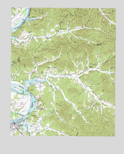
Clifton, TN USGS Topographic Map
Click on map above to begin viewing in our Map Viewer.

This topographic map contains these locations and features:
Feature Name Type Latitude Longitude GNIS ID View Map
Anderson HollowValleyN35.4687°W87.9971°1275716View Map
Beech CreekStreamN35.4198°W87.9806°1276807View Map
Beech Creek IslandIslandN35.4212°W87.9931°1276813View Map
Benham-Hughes-Speer CemeteryCemeteryN35.3820°W87.9564°1641751View Map
Bost ForkStreamN35.4367°W87.8842°1649033View Map
Boyd HollowValleyN35.4079°W87.8924°1278115View Map
Briley CemeteryCemeteryN35.4703°W87.9575°1642896View Map
Buckeye BranchStreamN35.3779°W87.9778°1278846View Map
Buttam HollowValleyN35.4017°W87.9705°1279197View Map
Caney HollowValleyN35.4995°W87.8950°1279581View Map
Carroll CemeteryCemeteryN35.4295°W87.9511°1641769View Map
Carrollville (historical)Populated PlaceN35.3912°W87.9778°1302712View Map
Carrollville HillSummitN35.3940°W87.9703°1279753View Map
City of CliftonCivilN35.3768°W87.9937°2404074View Map
CliftonPopulated PlaceN35.3870°W87.9953°1305972View Map
Clifton City ParkParkN35.3870°W87.9884°1317749View Map
Clifton FerryCrossingN35.3895°W87.9936°1302717View Map
Clifton Police DepartmentBuildingN35.3863°W87.9952°2765843View Map
Clifton Post OfficePost OfficeN35.3852°W87.9950°1649034View Map
Clifton Volunteer Fire DepartmentBuildingN35.3855°W87.9951°2653741View Map
Clifton-Natural Bridge Division (historical)CensusN35.3926°W87.8856°1269264View Map
Commissioner District 2CivilN35.3797°W87.9842°2463984View Map
Conway School (historical)SchoolN35.4095°W87.9297°1302723View Map
Cow HollowValleyN35.4061°W87.9483°1281444View Map
Crossno CemeteryCemeteryN35.4395°W87.8861°1281716View Map
Crossnoe CemeteryCemeteryN35.4634°W87.9628°1642900View Map
Culp CemeteryCemeteryN35.4415°W87.9106°1281813View Map
Culp CemeteryCemeteryN35.4634°W87.9859°1306222View Map
Culp HollowValleyN35.4372°W87.8839°1281814View Map
Cypress PondLakeN35.4833°W87.9939°1281944View Map
Deaton HollowValleyN35.4810°W87.9131°1282271View Map
Flippo BranchStreamN35.4265°W87.9817°1284496View Map
Flippo GraveCemeteryN35.4423°W87.9684°1641796View Map
Floyd HollowValleyN35.3777°W87.9607°1284526View Map
Frank Hughes SchoolSchoolN35.3823°W87.9939°1302745View Map
Glenkirk IslandIslandN35.4095°W87.9709°1285512View Map
Glenkirk LandingLocaleN35.4095°W87.9678°1315121View Map
Haggard HollowValleyN35.3776°W87.9861°1286494View Map
Hassell FieldAirportN35.3859°W87.9679°1301337View Map
Haynes HollowValleyN35.4097°W87.8969°1287234View Map
Haynes SpringSpringN35.4065°W87.8987°1287235View Map
Haynes Spring School (historical)SchoolN35.4065°W87.8992°1302753View Map
Helton CemeteryCemeteryN35.3837°W87.9750°1287350View Map
Henry Culp Family PlotCemeteryN35.4565°W87.8781°1641812View Map
Hill CemeteryCemeteryN35.3923°W87.8847°1641818View Map
Howell CemeteryCemeteryN35.4787°W87.9317°1288555View Map
Howell ForkStreamN35.4762°W87.9323°1288559View Map
Kittrell LandingLocaleN35.4879°W87.9786°1315336View Map
Kittrell RidgeRidgeN35.4845°W87.9661°1290335View Map
Kyle GraveCemeteryN35.4251°W87.9075°1641834View Map
Lane BranchStreamN35.4215°W87.9495°1290593View Map
Lego (historical)Populated PlaceN35.4873°W87.9811°1308586View Map
Lego LandingLocaleN35.4884°W87.9850°1315376View Map
Lego SchoolSchoolN35.4762°W87.9792°1291003View Map
Lineberry ForkStreamN35.4762°W87.9323°1291336View Map
Lineberry HollowValleyN35.4412°W87.8991°1291337View Map
Little Beech CreekStreamN35.4323°W87.9220°1291378View Map
Little Beech SchoolSchoolN35.4420°W87.9028°1291379View Map
Lone Chestnut CemeteryCemeteryN35.4051°W87.9989°1291839View Map
McGee HollowValleyN35.4298°W87.9786°1293304View Map
Methodist Camp Ground CemeteryCemeteryN35.4267°W87.9200°1641854View Map
Mill HollowValleyN35.4360°W87.8815°1293883View Map
Mill Hollow BranchStreamN35.4354°W87.8820°1646845View Map
MooneyPopulated PlaceN35.4109°W87.8939°1315533View Map
Morrison CreekStreamN35.4276°W87.9614°1294450View Map
Morrison HollowValleyN35.4744°W87.9283°1294453View Map
Mount Auburn CemeteryCemeteryN35.4467°W87.9995°1642908View Map
Mount Auburn ChurchChurchN35.4465°W87.9989°1294552View Map
New Bethlehem ChurchChurchN35.4415°W87.9534°1295443View Map
New Era BluffCliffN35.4962°W87.9778°1295474View Map
New Era RidgeRidgeN35.4920°W87.9031°1295476View Map
New Zion ChurchChurchN35.4448°W87.8975°1295672View Map
Newborn CemeteryCemeteryN35.3887°W87.9278°1641864View Map
Nunnley Ford CemeteryCemeteryN35.4226°W87.9653°1641866View Map
Parker BranchStreamN35.3792°W87.9728°1296794View Map
Penny SloughStreamN35.3940°W87.9836°1297159View Map
Penny Slough LandingLocaleN35.4023°W87.9773°1316769View Map
Peters LandingLocaleN35.4806°W87.9900°1315698View Map
Peters Landing Post OfficePost OfficeN35.4784°W87.9411°1648568View Map
Pevahouse HollowValleyN35.4462°W87.8955°1297283View Map
Poplar HollowValleyN35.4234°W87.9102°1298207View Map
Prater BranchStreamN35.4084°W87.8917°1298451View Map
Prater CemeteryCemeteryN35.4017°W87.8934°1298453View Map
Prater ChapelChurchN35.3979°W87.9503°1298457View Map
Primitive Baptist CemeteryCemeteryN35.4137°W87.9036°1641886View Map
Renfro HollowValleyN35.4336°W87.9784°1299216View Map
Richardson CemeteryCemeteryN35.4320°W87.9939°1299332View Map
Riley CemeteryCemeteryN35.4270°W87.8756°1299449View Map
Riley HollowValleyN35.4371°W87.8824°1299461View Map
Rocky Point School (historical)SchoolN35.3840°W87.9542°1302791View Map
Ross CreekStreamN35.3751°W87.9317°1300125View Map
Russ TowheadIslandN35.4159°W87.9834°1300298View Map
Ryan Childs GraveCemeteryN35.4165°W87.9336°1641897View Map
Sewell BranchStreamN35.4759°W87.9331°1301121View Map
Short CreekStreamN35.4892°W87.9803°1270187View Map
Short Creek ChurchChurchN35.4906°W87.9759°1270198View Map
Shut HollowValleyN35.4141°W87.8964°1270239View Map
Steele CemeteryCemeteryN35.4412°W87.9492°1303816View Map
Tate HollowValleyN35.4362°W87.9939°1272155View Map
Tucker CemeteryCemeteryN35.4053°W87.9884°1272943View Map
Tune HollowValleyN35.4856°W87.8809°1272980View Map
Turnbo HollowValleyN35.4429°W87.9198°1273056View Map
Walker CemeteryCemeteryN35.4656°W87.9914°1642911View Map
Warren HollowValleyN35.4393°W87.9080°1273836View Map
Warrington CemeteryCemeteryN35.3987°W87.9495°1304386View Map
Whiteoak ChurchChurchN35.4709°W87.9550°1274430View Map
Whiteoak School (historical)SchoolN35.4798°W87.9306°1308625View Map
Wilson HollowValleyN35.4940°W87.8883°1274832View Map
Zion CemeteryCemeteryN35.4448°W87.8970°1641932View Map

Note: Coordinates in the location and feature list above are referenced to NAD83 datum.


Copyright (C) 2008-2025 Ryan Niemi / Sunset Dynamics ... All Rights Reserved