TopoQuest Logo
Do you find TopoQuest useful?
Help keep TopoQuest running and adding new maps/features by donating!
Bitcoin:  19c7KJd3qBynnjoSw5npx9KScwjBe4ifkT
Litecoin:  LXs6TkuXGGXo1vDsWCkWVdjQX94eUKd6ui
Home View Maps Find Maps Find Places Resources & Links


Roseland, Louisiana Topographic Map

USGS Map Title: Roseland, LA
USGS Map MRC: 30090G5
DRG (GeoTIFF) Download: o30090g5.tif


Neighboring USGS Topographic Map Quads:


  Liverpool, LA  
30090H6
 

  Kentwood, LA  
30090H5
 

  Spring Creek, LA  
30090H4
 

  Greensburg, LA  
30090G6
 

  Roseland, LA  
30090G5
 

  Chesbrough, LA  
30090G4
 

  Montpelier, LA  
30090F6
 

  Amite, LA  
30090F5
 

  Loranger, LA  
30090F4


Map MRC Location:

N31°
W91°
N31°
W90°
H8 H7 H6 H5 H4 H3 H2 H1
G8 G7 G6 G5 G4 G3 G2 G1
F8 F7 F6 F5 F4 F3 F2 F1
E8 E7 E6 E5 E4 E3 E2 E1
D8 D7 D6 D5 D4 D3 D2 D1
C8 C7 C6 C5 C4 C3 C2 C1
B8 B7 B6 B5 B4 B3 B2 B1
A8 A7 A6 A5 A4 A3 A2 A1
N30°
W91°
N30°
W90°

Roseland, LA USGS 1:24K Topographic Map Preview:
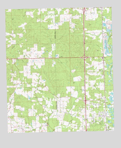
Roseland, LA USGS Topographic Map
Click on map above to begin viewing in our Map Viewer.

This topographic map contains these locations and features:
Feature Name Type Latitude Longitude GNIS ID View Map
Aaron BranchStreamN30.8191°W90.5073°532064View Map
Amite-Arcola ChurchChurchN30.7766°W90.5179°556651View Map
ArcolaPopulated PlaceN30.7766°W90.5104°553313View Map
Arcola-Roseland CemeteryCemeteryN30.7771°W90.5193°541899View Map
Ballards Mobile Home ParkPopulated PlaceN30.7794°W90.5114°2600383View Map
Barksdale BranchStreamN30.8288°W90.6212°559824View Map
Benton BranchStreamN30.7955°W90.5904°560148View Map
Big Zion CemeteryCemeteryN30.7593°W90.5231°541900View Map
Butler TempleChurchN30.8505°W90.6179°1628747View Map
Carpenter BranchStreamN30.8149°W90.5012°533773View Map
Cline BranchStreamN30.8485°W90.5009°560442View Map
Community Church of GodChurchN30.7504°W90.5374°2601524View Map
DayPopulated PlaceN30.8602°W90.5112°549644View Map
Eiland Lake DamDamN30.8618°W90.5918°680525View Map
First Baptist Church of ArcolaChurchN30.7912°W90.5344°2601767View Map
FlukerPopulated PlaceN30.8216°W90.5109°554444View Map
Fluker Chapel African Methodist Episcopal ChurchChurchN30.8107°W90.5145°556652View Map
Fluker Community Baptist ChurchChurchN30.8107°W90.5133°2602004View Map
Fluker Post OfficePost OfficeN30.8252°W90.5115°1631296View Map
Gaines ChapelChurchN30.8588°W90.5434°535146View Map
Hardy BranchStreamN30.8271°W90.6159°560941View Map
Huff BranchStreamN30.7699°W90.5776°1627310View Map
Huff ChapelChurchN30.7810°W90.5870°1627311View Map
Interchange 50CrossingN30.7810°W90.5329°541512View Map
Interchange 53CrossingN30.8249°W90.5332°541513View Map
Interchange 57CrossingN30.8730°W90.5323°541514View Map
Interstate Christian SchoolSchoolN30.7910°W90.5345°541901View Map
KedronPopulated PlaceN30.7566°W90.5773°1629287View Map
Kedron CemeteryCemeteryN30.7593°W90.5793°1628687View Map
Kedron ChurchChurchN30.7566°W90.5784°536149View Map
Kingdom Hall of Jehovahs WitnessesChurchN30.7775°W90.5341°2602137View Map
Louisiana Noname 107 DamDamN30.7952°W90.6084°1628770View Map
MitchellPopulated PlaceN30.8582°W90.5026°549714View Map
Mount Gillion ChurchChurchN30.7827°W90.5145°541902View Map
North Tangipahoa Head Start SchoolSchoolN30.7776°W90.5280°2600246View Map
Phillips CemeteryCemeteryN30.8657°W90.6176°1627913View Map
Pine Hill ChurchChurchN30.7988°W90.6143°1627929View Map
Revival Center Church of God in ChristChurchN30.7580°W90.5157°2602446View Map
Robinson PondReservoirN30.7952°W90.6084°1628771View Map
Rose Valley Baptist ChurchChurchN30.7606°W90.5149°2602352View Map
RoselandPopulated PlaceN30.7649°W90.5118°540668View Map
Roseland Baptist ChurchChurchN30.7671°W90.5172°2602353View Map
Roseland Elementary SchoolSchoolN30.7661°W90.5165°549740View Map
Roseland Fire DepartmentBuildingN30.7714°W90.5101°2332583View Map
Roseland Police DepartmentBuildingN30.7633°W90.5112°2334072View Map
Roseland Post OfficePost OfficeN30.7626°W90.5112°1631319View Map
Roseland Praise and Worship CenterChurchN30.7601°W90.5237°2602354View Map
Roseland Volunteer Fire DepartmentBuildingN30.7633°W90.5112°2332345View Map
Roseland Wastewater Treatment PlantLocaleN30.7554°W90.5187°2603502View Map
Saint Helena Parish Police JuryBuildingN30.7547°W90.6086°2333926View Map
Spring BranchStreamN30.8460°W90.5029°540670View Map
Tangipahoa CemeteryCemeteryN30.8693°W90.5248°541904View Map
Tangipahoa CemeteryCemeteryN30.8735°W90.5279°541905View Map
Tangipahoa Post OfficePost OfficeN30.8737°W90.5108°2600362View Map
Tangipahoa United Methodist ChurchChurchN30.8724°W90.5135°2602844View Map
Town of RoselandCivilN30.7646°W90.5114°2407246View Map
Watson CemeteryCemeteryN30.7991°W90.5479°540263View Map
West Natalbany CreekStreamN30.7785°W90.5737°1628479View Map
Woodland SchoolSchoolN30.7535°W90.6070°540519View Map

Note: Coordinates in the location and feature list above are referenced to NAD83 datum.


Copyright (C) 2008-2024 Ryan Niemi / Sunset Dynamics ... All Rights Reserved