TopoQuest Logo
Do you find TopoQuest useful?
Help keep TopoQuest running and adding new maps/features by donating!
Bitcoin:  19c7KJd3qBynnjoSw5npx9KScwjBe4ifkT
Litecoin:  LXs6TkuXGGXo1vDsWCkWVdjQX94eUKd6ui
Home View Maps Find Maps Find Places Resources & Links


Lizella, Georgia Topographic Map

USGS Map Title: Lizella, GA
USGS Map MRC: 32083G7
DRG (GeoTIFF) Download: o32083g7.tif


Neighboring USGS Topographic Map Quads:


  Smarr, GA  
32083H8
 

  Bolingbroke, GA  
32083H7
 

  Macon NW, GA  
32083H6
 

  Moran, GA  
32083G8
 

  Lizella, GA  
32083G7
 

  Macon West, GA  
32083G6
 

  Knoxville, GA  
32083F8
 

  Byron, GA  
32083F7
 

  Warner Robins NW, GA  
32083F6


Map MRC Location:

N33°
W84°
N33°
W83°
H8 H7 H6 H5 H4 H3 H2 H1
G8 G7 G6 G5 G4 G3 G2 G1
F8 F7 F6 F5 F4 F3 F2 F1
E8 E7 E6 E5 E4 E3 E2 E1
D8 D7 D6 D5 D4 D3 D2 D1
C8 C7 C6 C5 C4 C3 C2 C1
B8 B7 B6 B5 B4 B3 B2 B1
A8 A7 A6 A5 A4 A3 A2 A1
N32°
W84°
N32°
W83°

Lizella, GA USGS 1:24K Topographic Map Preview:
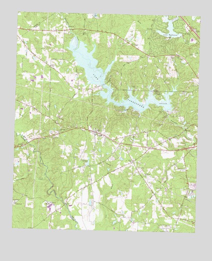
Lizella, GA USGS Topographic Map
Click on map above to begin viewing in our Map Viewer.

This topographic map contains these locations and features:
Feature Name Type Latitude Longitude GNIS ID View Map
Angels AcresPopulated PlaceN32.7696°W83.7594°1672024View Map
Arrowhead ParkParkN32.8204°W83.8013°310636View Map
BeaveroaksPopulated PlaceN32.8537°W83.8124°1672035View Map
Bethany CemeteryCemeteryN32.7987°W83.8688°342909View Map
Bethel ChurchChurchN32.7910°W83.7935°311186View Map
Blanton AcresPopulated PlaceN32.8015°W83.8132°1672042View Map
Blue BranchStreamN32.8313°W83.7671°311543View Map
CamelotPopulated PlaceN32.8612°W83.7777°1672063View Map
Central State PrisonBuildingN32.7770°W83.7518°2735710View Map
CherokeePopulated PlaceN32.8582°W83.7696°1672072View Map
Christophers CovePopulated PlaceN32.8343°W83.7813°1672090View Map
Clay LakeReservoirN32.8732°W83.8224°312705View Map
Clay South DamDamN32.8735°W83.8216°340226View Map
Clay South LakeReservoirN32.8745°W83.8219°340227View Map
Claystone ParkParkN32.8290°W83.7763°312708View Map
Commandment Keeping ChurchChurchN32.8524°W83.7638°312871View Map
Damascus ChurchChurchN32.8029°W83.8485°313273View Map
Davis CemeteryCemeteryN32.8643°W83.8635°1672096View Map
DixiePopulated PlaceN32.8668°W83.7643°1672098View Map
Dixon CemeteryCemeteryN32.7657°W83.8488°342924View Map
Dixon ChurchChurchN32.7654°W83.8482°355508View Map
Dogwood PlantationPopulated PlaceN32.7713°W83.7727°1672099View Map
Doles ChurchChurchN32.8504°W83.7616°313530View Map
Dougherty LakeReservoirN32.7887°W83.8243°313590View Map
Dougherty Lake DamDamN32.7885°W83.8244°340934View Map
Faith TempleChurchN32.7901°W83.7949°1672118View Map
Fambro ChapelChurchN32.8576°W83.7946°314074View Map
Fellowship CemeteryCemeteryN32.7646°W83.8738°342925View Map
Fenley Ryther DamDamN32.8201°W83.7716°336169View Map
Flintrock ParkParkN32.8196°W83.7735°314228View Map
Friendship ChapelChurchN32.7646°W83.8741°355919View Map
Holy Grove ChurchChurchN32.8637°W83.8296°315595View Map
Kings CovePopulated PlaceN32.8546°W83.7830°1672182View Map
Lake TobesofkeeReservoirN32.8230°W83.8024°336170View Map
Lake WildwoodReservoirN32.8667°W83.7703°325297View Map
Lake Wildwood DamDamN32.8632°W83.7630°340932View Map
LakeviewPopulated PlaceN32.8746°W83.7693°1672188View Map
Lakeview ChapelChurchN32.8332°W83.7932°316577View Map
LizellaPopulated PlaceN32.8071°W83.8199°317263View Map
Lizella ChurchChurchN32.8051°W83.8196°1672195View Map
Lizella DivisionCivilN32.7999°W83.7938°1936369View Map
Macedonia Church (historical)ChurchN32.7918°W83.8113°1672202View Map
Macon - Bibb County Fire Department Station 104BuildingN32.7568°W83.7564°2604842View Map
Macon - Bibb County Fire Department Station 105BuildingN32.8082°W83.8280°2604053View Map
Macon - Bibb County Fire Department Station 106BuildingN32.8509°W83.7597°2604252View Map
Marshalls Mill (historical)LocaleN32.7654°W83.8391°1672211View Map
Midway ChurchChurchN32.8443°W83.8513°318122View Map
Mount Paran ChurchChurchN32.7985°W83.8691°318796View Map
Open Bible TabernacleChurchN32.7657°W83.8507°320074View Map
Phelps EstatesPopulated PlaceN32.7882°W83.8019°1672251View Map
Pineworth by the LakePopulated PlaceN32.8188°W83.7666°1672253View Map
Pleasant Grove ChurchChurchN32.7824°W83.7849°320818View Map
Pleasant Grove School (historical)SchoolN32.7896°W83.7946°334126View Map
Redding SchoolSchoolN32.8051°W83.8157°321418View Map
Rockmill (historical)Populated PlaceN32.8635°W83.8360°1672270View Map
Rogers AcresPopulated PlaceN32.7565°W83.7846°1672271View Map
Saint Dennis CemeteryCemeteryN32.8405°W83.8699°322058View Map
Saint Dennis Church (historical)ChurchN32.8407°W83.8702°334127View Map
Sandy Beach ParkParkN32.8285°W83.7882°1672279View Map
ShadowoodPopulated PlaceN32.8029°W83.7955°1672282View Map
Sherwood ForestPopulated PlaceN32.8679°W83.7766°1672283View Map
Sofkee EstatesPopulated PlaceN32.8113°W83.8152°1672290View Map
Southeastern Holiness CampLocaleN32.7657°W83.8735°342966View Map
Stackler LakeReservoirN32.7635°W83.8494°340957View Map
Stackler Lake DamDamN32.7651°W83.8482°340956View Map
Stratford AcademySchoolN32.8632°W83.7543°1672297View Map
Sweetwater CreekStreamN32.7804°W83.8521°323837View Map
TaraPopulated PlaceN32.8707°W83.7652°1672307View Map
Trails EndPopulated PlaceN32.8546°W83.7763°1672316View Map
West PointPopulated PlaceN32.7935°W83.8074°1672343View Map
Whispering PinesPopulated PlaceN32.8718°W83.7782°1672350View Map
White Spring ChurchChurchN32.8071°W83.8435°325194View Map
White Spring School (historical)SchoolN32.8085°W83.8416°1672352View Map

Note: Coordinates in the location and feature list above are referenced to NAD83 datum.


Copyright (C) 2008-2024 Ryan Niemi / Sunset Dynamics ... All Rights Reserved