TopoQuest Logo
Do you find TopoQuest useful?
Help keep TopoQuest running and adding new maps/features by donating!
Bitcoin:  19c7KJd3qBynnjoSw5npx9KScwjBe4ifkT
Litecoin:  LXs6TkuXGGXo1vDsWCkWVdjQX94eUKd6ui
Home View Maps Find Maps Find Places Resources & Links


Byron, Georgia Topographic Map

USGS Map Title: Byron, GA
USGS Map MRC: 32083F7
DRG (GeoTIFF) Download: o32083f7.tif


Neighboring USGS Topographic Map Quads:


  Moran, GA  
32083G8
 

  Lizella, GA  
32083G7
 

  Macon West, GA  
32083G6
 

  Knoxville, GA  
32083F8
 

  Byron, GA  
32083F7
 

  Warner Robins NW, GA  
32083F6
 

  Fort Valley West, GA  
32083E8
 

  Fort Valley East, GA  
32083E7
 

  Warner Robins SW, GA  
32083E6


Map MRC Location:

N33°
W84°
N33°
W83°
H8 H7 H6 H5 H4 H3 H2 H1
G8 G7 G6 G5 G4 G3 G2 G1
F8 F7 F6 F5 F4 F3 F2 F1
E8 E7 E6 E5 E4 E3 E2 E1
D8 D7 D6 D5 D4 D3 D2 D1
C8 C7 C6 C5 C4 C3 C2 C1
B8 B7 B6 B5 B4 B3 B2 B1
A8 A7 A6 A5 A4 A3 A2 A1
N32°
W84°
N32°
W83°

Byron, GA USGS 1:24K Topographic Map Preview:
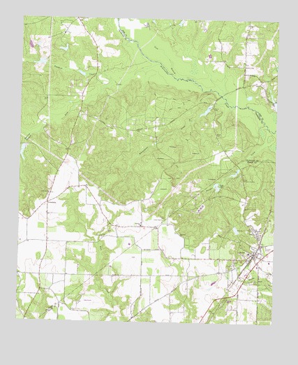
Byron, GA USGS Topographic Map
Click on map above to begin viewing in our Map Viewer.

This topographic map contains these locations and features:
Feature Name Type Latitude Longitude GNIS ID View Map
Allen TempleChurchN32.6638°W83.7610°310459View Map
Alpine HeightsPopulated PlaceN32.6585°W83.7619°343120View Map
Arnold-Mason CemeteryCemeteryN32.7053°W83.8303°2722977View Map
Atwaters CemeteryCemeteryN32.6893°W83.8304°2723038View Map
Brown-Hallman Family CemeteryCemeteryN32.7029°W83.7794°2722980View Map
ByronPopulated PlaceN32.6538°W83.7596°354930View Map
Byron Baptist ChurchChurchN32.6543°W83.7596°343121View Map
Byron Elementary SchoolSchoolN32.6540°W83.7621°343122View Map
Byron Police DepartmentBuildingN32.6542°W83.7621°2733804View Map
Byron Public LibraryBuildingN32.6504°W83.7591°343123View Map
Byron SchoolSchoolN32.6507°W83.7521°343124View Map
Byron Volunteer Fire DepartmentBuildingN32.6511°W83.7560°2604830View Map
Camp Benjamin HawkinsLocaleN32.6843°W83.7663°354958View Map
City of ByronCivilN32.6475°W83.7540°2403961View Map
Crawford County Fire Department Station 3BuildingN32.7493°W83.8484°2604352View Map
Crawford County Fire Department Station 6BuildingN32.6772°W83.8603°2604233View Map
Deep CreekStreamN32.7315°W83.8074°313410View Map
Duke Airport (historical)AirportN32.6329°W83.8399°343128View Map
Echeconnee AcresPopulated PlaceN32.7201°W83.7569°1672106View Map
FriendshipPopulated PlaceN32.6740°W83.8610°331772View Map
Friendship ChurchChurchN32.6615°W83.7960°355933View Map
Friendship Community CenterBuildingN32.6690°W83.8671°342927View Map
Friendship School (historical)SchoolN32.6615°W83.7960°343141View Map
Gum BranchStreamN32.7260°W83.7921°314958View Map
Hardison ChurchChurchN32.6649°W83.8152°356170View Map
Hartley BranchStreamN32.7021°W83.8699°315215View Map
Hartley BridgesBridgeN32.7193°W83.7766°1672148View Map
Hidden ForestPopulated PlaceN32.6651°W83.7744°343144View Map
Hutto Farm AirportAirportN32.6803°W83.8562°2442683View Map
Jordan ChapelChurchN32.6674°W83.8052°316265View Map
Jordan Chapel CemeteryCemeteryN32.6676°W83.8046°342935View Map
Kraftsman Association LakeReservoirN32.7124°W83.7844°337749View Map
Kraftsman Association Lake DamDamN32.7135°W83.7816°337748View Map
Merritt LakeReservoirN32.7374°W83.8543°337760View Map
Merritt Lake DamDamN32.7368°W83.8532°337759View Map
New Life Fellowship ChurchChurchN32.7074°W83.8366°342947View Map
Newberry LakeReservoirN32.7491°W83.7973°341496View Map
Newberry Lake DamDamN32.7468°W83.7982°341495View Map
Nike Site R-88C (historical)MilitaryN32.6744°W83.7653°1987833View Map
Nike Site R-88L (historical)MilitaryN32.6722°W83.7861°1987834View Map
Nimrod Jackson CemeteryCemeteryN32.7114°W83.7792°2722988View Map
Saint Marks ChurchChurchN32.7479°W83.8566°342963View Map
Sandhill CreekStreamN32.7235°W83.8310°322450View Map
Scout LakeReservoirN32.6872°W83.7694°336301View Map
Society Hill CemeteryCemeteryN32.6785°W83.8599°342965View Map
Society Hill ChurchChurchN32.6782°W83.8599°323210View Map
South Lake DamDamN32.6885°W83.7682°336300View Map
Spring Hill CemeteryCemeteryN32.6604°W83.8330°342969View Map
Spring Hill ChurchChurchN32.6601°W83.8332°323429View Map
Twin LakesReservoirN32.6813°W83.7771°324450View Map
Waldron CemeteryCemeteryN32.7310°W83.7660°324757View Map
Whitewater CreekStreamN32.7165°W83.7752°325226View Map
WJTG-FM (Fort Valley)TowerN32.6910°W83.8624°352692View Map

Note: Coordinates in the location and feature list above are referenced to NAD83 datum.


Copyright (C) 2008-2024 Ryan Niemi / Sunset Dynamics ... All Rights Reserved