TopoQuest Logo
Do you find TopoQuest useful?
Help keep TopoQuest running and adding new maps/features by donating!
Bitcoin:  19c7KJd3qBynnjoSw5npx9KScwjBe4ifkT
Litecoin:  LXs6TkuXGGXo1vDsWCkWVdjQX94eUKd6ui
Home View Maps Find Maps Find Places Resources & Links


Loco Mountain, New Mexico Topographic Map

USGS Map Title: Loco Mountain, NM
USGS Map MRC: 33108D4
DRG (GeoTIFF) Download: o33108d4.tif


Neighboring USGS Topographic Map Quads:


  Telephone Canyon, NM  
33108E5
 

  Pitchfork Canyon, NM  
33108E4
 

  O Bar O Canyon West, NM  
33108E3
 

  Negrito Mountain, NM  
33108D5
 

  Loco Mountain, NM  
33108D4
 

  Canyon Creek Mountains, NM  
33108D3
 

  Mogollon Baldy Peak, NM  
33108C5
 

  Lilley Mountain, NM  
33108C4
 

  Woodland Park, NM  
33108C3


Map MRC Location:

N34°
W109°
N34°
W108°
H8 H7 H6 H5 H4 H3 H2 H1
G8 G7 G6 G5 G4 G3 G2 G1
F8 F7 F6 F5 F4 F3 F2 F1
E8 E7 E6 E5 E4 E3 E2 E1
D8 D7 D6 D5 D4 D3 D2 D1
C8 C7 C6 C5 C4 C3 C2 C1
B8 B7 B6 B5 B4 B3 B2 B1
A8 A7 A6 A5 A4 A3 A2 A1
N33°
W109°
N33°
W108°

Loco Mountain, NM USGS 1:24K Topographic Map Preview:
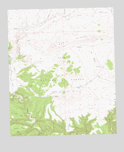
Loco Mountain, NM USGS Topographic Map
Click on map above to begin viewing in our Map Viewer.

This topographic map contains these locations and features:
Feature Name Type Latitude Longitude GNIS ID View Map
Aeroplane MesaSummitN33.3806°W108.4309°902997View Map
Clayton CreekStreamN33.3840°W108.4731°905197View Map
Clayton MesaSummitN33.3867°W108.4931°905198View Map
Clayton SpringSpringN33.3792°W108.4934°905200View Map
Dipping Vat TankReservoirN33.4178°W108.4962°905773View Map
Doubtful TankReservoirN33.4957°W108.3931°905840View Map
Elladene TankReservoirN33.4810°W108.4947°906135View Map
Ewe CanyonValleyN33.4531°W108.4984°906212View Map
Fence TankReservoirN33.4943°W108.4378°906254View Map
Fresno TankReservoirN33.4802°W108.3982°912697View Map
Gail TankReservoirN33.4793°W108.4802°906437View Map
Gilita CreekStreamN33.4145°W108.4903°906546View Map
Hay CanyonValleyN33.4940°W108.4356°906879View Map
Iron CreekStreamN33.3873°W108.4748°907250View Map
Juniper TankReservoirN33.4419°W108.3925°907497View Map
Kathy TankReservoirN33.4403°W108.4251°2038529View Map
Laurie TankReservoirN33.4009°W108.4075°907898View Map
Little Loco TankReservoirN33.4222°W108.4180°908033View Map
Loco MountainSummitN33.4134°W108.4470°908110View Map
Loco Mountain TankReservoirN33.4193°W108.4484°908111View Map
Moonshine CanyonValleyN33.3787°W108.4628°908885View Map
Pitchfork CanyonValleyN33.4915°W108.4334°909743View Map
Porcupine CanyonValleyN33.3751°W108.4384°909794View Map
Quaking Aspen CreekStreamN33.4515°W108.4981°909915View Map
Reed TankReservoirN33.4240°W108.4773°910106View Map
S S BasinBasinN33.4523°W108.4009°910487View Map
School CanyonValleyN33.4387°W108.4951°910869View Map
Seven HL CanyonValleyN33.4831°W108.4648°910958View Map
Snow CanyonValleyN33.4145°W108.4903°911174View Map
Snow LakeReservoirN33.4151°W108.4956°923840View Map
Snow LakeLakeN33.4226°W108.4963°912698View Map
Snow Lake DamDamN33.4151°W108.4956°923839View Map
T Bar CanyonValleyN33.4473°W108.4976°911516View Map
T Bar RidgeRidgeN33.4667°W108.4317°911517View Map
T Bar TankReservoirN33.4929°W108.4190°911519View Map
Three Forks TankReservoirN33.3916°W108.4320°911678View Map

Note: Coordinates in the location and feature list above are referenced to NAD83 datum.


Copyright (C) 2008-2024 Ryan Niemi / Sunset Dynamics ... All Rights Reserved